![](/images/other/stat-length.png)
![Tour Wandern Valdeblore - Lac Tavels - Photo](https://media.geolcdn.com/t/1900/400/f18f4dc3-f4aa-46b7-8ec6-30c574c3a5f8.jpg&format=pjpeg&maxdim=2)
Lac Tavels
aris
Benutzer
![Länge](/images/other/stat-length.png)
Länge
7,1 km
![Maximale Höhe](https://static1.geolcdn.com/siteimages/upload/files/1508320355ic_sort_altitude_max_24dp.png)
Maximale Höhe
2386 m
![Positive Höhendifferenz](https://static1.geolcdn.com/siteimages/upload/files/1508320355ic_sort_den_pos_24dp.png)
Positive Höhendifferenz
244 m
![Km-Effort](/images/other/stat-length.png)
Km-Effort
10,9 km
![Min. Höhe](https://static1.geolcdn.com/siteimages/upload/files/1508320355ic_sort_altitude_min_24dp.png)
Min. Höhe
2083 m
![Negative Höhendifferenz](https://static1.geolcdn.com/siteimages/upload/files/1508320355ic_sort_den_neg_24dp.png)
Negative Höhendifferenz
418 m
![Boucle](https://static1.geolcdn.com/siteimages/upload/files/16400158638029165_repeat_loop_refresh_sync_direction_icon.png)
Boucle
Nein
Erstellungsdatum :
2015-07-14 00:00:00.0
Letzte Änderung :
2020-06-06 22:05:07.922
![Wandern](https://static1.geolcdn.com/sitytour/trail-icons/101.png)
3h41
Schwierigkeit : Medium
![Scannen Sie diesen QR-Code, um die Tour in der SityTrail-Anwendung zu öffnen](https://capi.geolives.com/qq0zvz2zws4bq2lad0pu/sitytour/trails/445381/qr.png?size=200)
Kostenlosegpshiking-Anwendung
Über SityTrail
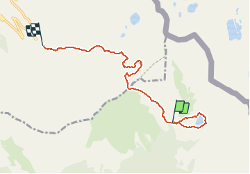
Tour Wandern von 7,1 km verfügbar auf Provence-Alpes-Côte d'Azur, Seealpen, Valdeblore. Diese Tour wird von aris vorgeschlagen.
Beschreibung
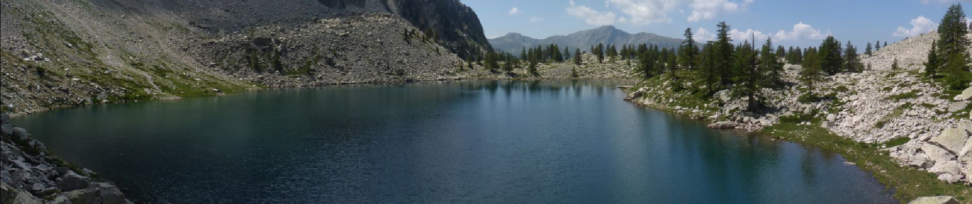
Magnifique lac de montagne, d'accès facile par le col Mercière.
La trace GPX ne montre que le retour (et aussi le tour du Lac).
Ort
Land:
France
Region :
Provence-Alpes-Côte d'Azur
Abteilung/Provinz :
Seealpen
Kommune :
Valdeblore
Standort:
Unknown
Gehen Sie:(Dec)
Gehen Sie:(UTM)
355706 ; 4892517 (32T) N.
Kommentare
Touren in der Umgebung
![Tour Andere Aktivitäten Isola - Isola 2000 baisse Druos refuge Quesa - Photo](https://media.geolcdn.com/t/375/260/ext.jpg?maxdim=2&url=https%3A%2F%2Fservices.sitytrail.com%2FGeolivesWS%2FDownloadMedia.ashx%3FTrailID%3D631831%26Media%3Dfix__20160806152443.jpg)
![Andere Aktivitäten Andere Aktivitäten](https://static1.geolcdn.com/sitytour/trail-icons/900.png)
Isola 2000 baisse Druos refuge Quesa
Andere Aktivitäten
Sehr leicht
(1)
Isola,
Provence-Alpes-Côte d'Azur,
Seealpen,
France
![](/images/other/stat-length.png)
21 km | 35 km-effort
8h 5min
![](https://static1.geolcdn.com/siteimages/upload/files/16400158638029165_repeat_loop_refresh_sync_direction_icon.png)
Ja
![Tour Wandern Isola - Tête Mercière et Lacs de terre rouge 24.8.24 - Photo](https://media.geolcdn.com/t/375/260/3e3a1aaf-e381-4ca9-a18c-df28b1091979.jpg&format=jpg&maxdim=2)
![Wandern Wandern](https://static1.geolcdn.com/sitytour/trail-icons/101.png)
Tête Mercière et Lacs de terre rouge 24.8.24
Wandern
Medium
Isola,
Provence-Alpes-Côte d'Azur,
Seealpen,
France
![](/images/other/stat-length.png)
11,6 km | 18 km-effort
4h 0min
![](https://static1.geolcdn.com/siteimages/upload/files/16400158638029165_repeat_loop_refresh_sync_direction_icon.png)
Nein
![Tour Zu Fuß Isola - Tête Mercière - Photo](https://media.geolcdn.com/t/375/260/8e1ca2e5-a446-45a1-b4b9-1747f6caafe0.jpeg&format=jpg&maxdim=2)
![Zu Fuß Zu Fuß](https://static1.geolcdn.com/sitytour/trail-icons/100.png)
Tête Mercière
Zu Fuß
Einfach
Isola,
Provence-Alpes-Côte d'Azur,
Seealpen,
France
![](/images/other/stat-length.png)
8,1 km | 14,8 km-effort
3h 21min
![](https://static1.geolcdn.com/siteimages/upload/files/16400158638029165_repeat_loop_refresh_sync_direction_icon.png)
Nein
![Tour Zu Fuß Saint-Martin-Vésubie - Circuit des Adus - Photo](https://media.geolcdn.com/t/375/260/1d6d9ad9-9540-40e2-b71d-1e8a26b80478.jpeg&format=jpg&maxdim=2)
![Zu Fuß Zu Fuß](https://static1.geolcdn.com/sitytour/trail-icons/100.png)
Circuit des Adus
Zu Fuß
Einfach
Saint-Martin-Vésubie,
Provence-Alpes-Côte d'Azur,
Seealpen,
France
![](/images/other/stat-length.png)
9,9 km | 18,8 km-effort
4h 16min
![](https://static1.geolcdn.com/siteimages/upload/files/16400158638029165_repeat_loop_refresh_sync_direction_icon.png)
Ja
![Tour Zu Fuß Valdeblore - Lac Nègre - Photo](https://media.geolcdn.com/t/375/260/523722db-6e8e-40d3-b22f-f8992cf9694d.jpeg&format=jpg&maxdim=2)
![Zu Fuß Zu Fuß](https://static1.geolcdn.com/sitytour/trail-icons/100.png)
Lac Nègre
Zu Fuß
Einfach
Valdeblore,
Provence-Alpes-Côte d'Azur,
Seealpen,
France
![](/images/other/stat-length.png)
11,1 km | 19,6 km-effort
4h 27min
![](https://static1.geolcdn.com/siteimages/upload/files/16400158638029165_repeat_loop_refresh_sync_direction_icon.png)
Ja
![Tour Wandern Isola - cime de la lombarde - Photo](https://media.geolcdn.com/t/375/260/ext.jpg?maxdim=2&url=https%3A%2F%2Fstatic1.geolcdn.com%2Fsiteimages%2Fupload%2Ffiles%2F1553511878bg_sport_marche.png)
![Wandern Wandern](https://static1.geolcdn.com/sitytour/trail-icons/101.png)
cime de la lombarde
Wandern
Sehr schwierig
(1)
Isola,
Provence-Alpes-Côte d'Azur,
Seealpen,
France
![](/images/other/stat-length.png)
16,7 km | 31 km-effort
9h 25min
![](https://static1.geolcdn.com/siteimages/upload/files/16400158638029165_repeat_loop_refresh_sync_direction_icon.png)
Ja
![Tour Wandern Saint-Martin-Vésubie - lacs de Frémamorte - Photo](https://media.geolcdn.com/t/375/260/ext.jpg?maxdim=2&url=https%3A%2F%2Fstatic1.geolcdn.com%2Fsiteimages%2Fupload%2Ffiles%2F1553511878bg_sport_marche.png)
![Wandern Wandern](https://static1.geolcdn.com/sitytour/trail-icons/101.png)
lacs de Frémamorte
Wandern
Medium
(1)
Saint-Martin-Vésubie,
Provence-Alpes-Côte d'Azur,
Seealpen,
France
![](/images/other/stat-length.png)
15,6 km | 26 km-effort
5h 24min
![](https://static1.geolcdn.com/siteimages/upload/files/16400158638029165_repeat_loop_refresh_sync_direction_icon.png)
Nein
![Tour Wandern Vinadio - Cime de la Lombarde 2800m 26.8.24 - Photo](https://media.geolcdn.com/t/375/260/a90fbc15-b832-4be5-b4ba-c6dcb34efb02.jpg&format=jpg&maxdim=2)
![Wandern Wandern](https://static1.geolcdn.com/sitytour/trail-icons/101.png)
Cime de la Lombarde 2800m 26.8.24
Wandern
Sehr schwierig
Vinadio,
Piemont,
Cuneo,
Italy
![](/images/other/stat-length.png)
3,4 km | 9,1 km-effort
2h 30min
![](https://static1.geolcdn.com/siteimages/upload/files/16400158638029165_repeat_loop_refresh_sync_direction_icon.png)
Ja
![Tour sport Isola - Baisse druos - Photo](https://media.geolcdn.com/t/375/260/4a5a3848-1bb0-4b92-8e5a-b87b41fd07ce.jpg&format=jpg&maxdim=2)
Baisse druos
sport
Sehr leicht
Isola,
Provence-Alpes-Côte d'Azur,
Seealpen,
France
![](/images/other/stat-length.png)
9,3 km | 16,3 km-effort
Unbekannt
![](https://static1.geolcdn.com/siteimages/upload/files/16400158638029165_repeat_loop_refresh_sync_direction_icon.png)
Ja