![](/images/other/stat-length.png)
![Tour Andere Aktivitäten Glarus Süd - Brunalpelihöchi - Photo](https://media.geolcdn.com/t/1900/400/ext.pjpeg?maxdim=2&url=https%3A%2F%2Fstatic1.geolcdn.com%2Fsiteimages%2Fupload%2Ffiles%2F1545311037marcheuse_200dpi.jpg)
Brunalpelihöchi
alternatives-wandern
Benutzer
![Länge](/images/other/stat-length.png)
Länge
20 km
![Maximale Höhe](https://static1.geolcdn.com/siteimages/upload/files/1508320355ic_sort_altitude_max_24dp.png)
Maximale Höhe
2244 m
![Positive Höhendifferenz](https://static1.geolcdn.com/siteimages/upload/files/1508320355ic_sort_den_pos_24dp.png)
Positive Höhendifferenz
1196 m
![Km-Effort](/images/other/stat-length.png)
Km-Effort
37 km
![Min. Höhe](https://static1.geolcdn.com/siteimages/upload/files/1508320355ic_sort_altitude_min_24dp.png)
Min. Höhe
855 m
![Negative Höhendifferenz](https://static1.geolcdn.com/siteimages/upload/files/1508320355ic_sort_den_neg_24dp.png)
Negative Höhendifferenz
1595 m
![Boucle](https://static1.geolcdn.com/siteimages/upload/files/16400158638029165_repeat_loop_refresh_sync_direction_icon.png)
Boucle
Nein
Erstellungsdatum :
2014-12-10 00:00:00.0
Letzte Änderung :
2014-12-10 00:00:00.0
![Andere Aktivitäten](https://static1.geolcdn.com/sitytour/trail-icons/900.png)
--
Schwierigkeit : Unbekannt
![Scannen Sie diesen QR-Code, um die Tour in der SityTrail-Anwendung zu öffnen](https://capi.geolives.com/qq0zvz2zws4bq2lad0pu/sitytour/trails/44209/qr.png?size=200)
Kostenlosegpshiking-Anwendung
Über SityTrail
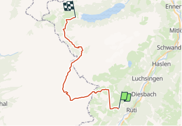
Tour Andere Aktivitäten von 20 km verfügbar auf Glarus, Unbekannt, Glarus Süd. Diese Tour wird von alternatives-wandern vorgeschlagen.
Beschreibung
Detailbeschreibung siehe Wanderbeschreibung und eigenes Höhenprofil.
http://www.alternatives-wandern.ch/touren/sommer/brunalpelihoechi.htm
Ort
Land:
Switzerland
Region :
Glarus
Abteilung/Provinz :
Unbekannt
Kommune :
Glarus Süd
Standort:
Unknown
Gehen Sie:(Dec)
Gehen Sie:(UTM)
499872 ; 5198375 (32T) N.
Kommentare
Touren in der Umgebung
![Tour Zu Fuß Muotathal - CH-Dräckloch - nördlich Brunalpelhöchi - Photo](https://media.geolcdn.com/t/375/260/1488713b-4132-4a2c-891b-15a110ce134e.jpeg&format=jpg&maxdim=2)
![Zu Fuß Zu Fuß](https://static1.geolcdn.com/sitytour/trail-icons/100.png)
CH-Dräckloch - nördlich Brunalpelhöchi
Zu Fuß
Einfach
Muotathal,
Schwyz,
Schwyz,
Switzerland
![](/images/other/stat-length.png)
3,2 km | 7,1 km-effort
1h 36min
![](https://static1.geolcdn.com/siteimages/upload/files/16400158638029165_repeat_loop_refresh_sync_direction_icon.png)
Nein
![Tour Zu Fuß Muotathal - CH-Dräckloch - Chäseren - Photo](https://media.geolcdn.com/t/375/260/1488713b-4132-4a2c-891b-15a110ce134e.jpeg&format=jpg&maxdim=2)
![Zu Fuß Zu Fuß](https://static1.geolcdn.com/sitytour/trail-icons/100.png)
CH-Dräckloch - Chäseren
Zu Fuß
Einfach
Muotathal,
Schwyz,
Schwyz,
Switzerland
![](/images/other/stat-length.png)
3,6 km | 5,4 km-effort
1h 13min
![](https://static1.geolcdn.com/siteimages/upload/files/16400158638029165_repeat_loop_refresh_sync_direction_icon.png)
Nein
![Tour Zu Fuß Glarus Süd - Panoramawanderung Braunwald - Photo](https://media.geolcdn.com/t/375/260/260a3306-3898-4818-992c-71645d2b4614.jpeg&format=jpg&maxdim=2)
![Zu Fuß Zu Fuß](https://static1.geolcdn.com/sitytour/trail-icons/100.png)
Panoramawanderung Braunwald
Zu Fuß
Einfach
Glarus Süd,
Glarus,
Unbekannt,
Switzerland
![](/images/other/stat-length.png)
9,3 km | 14,9 km-effort
3h 23min
![](https://static1.geolcdn.com/siteimages/upload/files/16400158638029165_repeat_loop_refresh_sync_direction_icon.png)
Ja
![Tour Andere Aktivitäten Glarus Süd - y10_urnerboden - Photo](https://media.geolcdn.com/t/375/260/ext.jpg?maxdim=2&url=https%3A%2F%2Fstatic1.geolcdn.com%2Fsiteimages%2Fupload%2Ffiles%2F1545311037marcheuse_200dpi.jpg)
![Andere Aktivitäten Andere Aktivitäten](https://static1.geolcdn.com/sitytour/trail-icons/900.png)
y10_urnerboden
Andere Aktivitäten
Sehr leicht
Glarus Süd,
Glarus,
Unbekannt,
Switzerland
![](/images/other/stat-length.png)
8,4 km | 13,8 km-effort
3h 32min
![](https://static1.geolcdn.com/siteimages/upload/files/16400158638029165_repeat_loop_refresh_sync_direction_icon.png)
Nein
![Tour Andere Aktivitäten Glarus Süd - y10_oberblegisee_braunwald - Photo](https://media.geolcdn.com/t/375/260/ext.jpg?maxdim=2&url=https%3A%2F%2Fstatic1.geolcdn.com%2Fsiteimages%2Fupload%2Ffiles%2F1545311037marcheuse_200dpi.jpg)
![Andere Aktivitäten Andere Aktivitäten](https://static1.geolcdn.com/sitytour/trail-icons/900.png)
y10_oberblegisee_braunwald
Andere Aktivitäten
Sehr leicht
Glarus Süd,
Glarus,
Unbekannt,
Switzerland
![](/images/other/stat-length.png)
16,3 km | 25 km-effort
5h 14min
![](https://static1.geolcdn.com/siteimages/upload/files/16400158638029165_repeat_loop_refresh_sync_direction_icon.png)
Nein
![Tour Wandern Glarus Süd - passKlausen_passonly - Photo](https://media.geolcdn.com/t/375/260/ext.jpg?maxdim=2&url=https%3A%2F%2Fstatic1.geolcdn.com%2Fsiteimages%2Fupload%2Ffiles%2F1553511878bg_sport_marche.png)
![Wandern Wandern](https://static1.geolcdn.com/sitytour/trail-icons/101.png)
passKlausen_passonly
Wandern
Sehr leicht
Glarus Süd,
Glarus,
Unbekannt,
Switzerland
![](/images/other/stat-length.png)
23 km | 38 km-effort
Unbekannt
![](https://static1.geolcdn.com/siteimages/upload/files/16400158638029165_repeat_loop_refresh_sync_direction_icon.png)
Nein
![Tour Wandern Glarus Süd - wa38 - Photo](https://media.geolcdn.com/t/375/260/ext.jpg?maxdim=2&url=https%3A%2F%2Fstatic1.geolcdn.com%2Fsiteimages%2Fupload%2Ffiles%2F1553511878bg_sport_marche.png)
![Wandern Wandern](https://static1.geolcdn.com/sitytour/trail-icons/101.png)
wa38
Wandern
Sehr leicht
Glarus Süd,
Glarus,
Unbekannt,
Switzerland
![](/images/other/stat-length.png)
9,3 km | 18,4 km-effort
5h 16min
![](https://static1.geolcdn.com/siteimages/upload/files/16400158638029165_repeat_loop_refresh_sync_direction_icon.png)
Nein
![Tour Mountainbike Glarus Süd - Bike32870 - Photo](https://media.geolcdn.com/t/375/260/ext.jpg?maxdim=2&url=https%3A%2F%2Fstatic1.geolcdn.com%2Fsiteimages%2Fupload%2Ffiles%2F1524743154velo.jpg)
![Mountainbike Mountainbike](https://static1.geolcdn.com/sitytour/trail-icons/202.png)
Bike32870
Mountainbike
Sehr leicht
Glarus Süd,
Glarus,
Unbekannt,
Switzerland
![](/images/other/stat-length.png)
8,9 km | 15,6 km-effort
5h 22min
![](https://static1.geolcdn.com/siteimages/upload/files/16400158638029165_repeat_loop_refresh_sync_direction_icon.png)
Ja
![Tour Wandern Glarus Süd - Via Alpina 06b Braunwald - Klausenpass - Photo](https://media.geolcdn.com/t/375/260/ext.jpg?maxdim=2&url=https%3A%2F%2Fstatic1.geolcdn.com%2Fsiteimages%2Fupload%2Ffiles%2F1553511878bg_sport_marche.png)
![Wandern Wandern](https://static1.geolcdn.com/sitytour/trail-icons/101.png)
Via Alpina 06b Braunwald - Klausenpass
Wandern
Medium
Glarus Süd,
Glarus,
Unbekannt,
Switzerland
![](/images/other/stat-length.png)
19,3 km | 32 km-effort
6h 37min
![](https://static1.geolcdn.com/siteimages/upload/files/16400158638029165_repeat_loop_refresh_sync_direction_icon.png)
Nein