![](/images/other/stat-length.png)
![Tour Wandern Les Sables-d'Olonne - brem sur mers - Photo](https://media.geolcdn.com/t/1900/400/ext.pjpeg?maxdim=2&url=https%3A%2F%2Fstatic1.geolcdn.com%2Fsiteimages%2Fupload%2Ffiles%2F1553511878bg_sport_marche.png)
brem sur mers
nicolas.gx
Benutzer
![Länge](/images/other/stat-length.png)
Länge
5,8 km
![Maximale Höhe](https://static1.geolcdn.com/siteimages/upload/files/1508320355ic_sort_altitude_max_24dp.png)
Maximale Höhe
10 m
![Positive Höhendifferenz](https://static1.geolcdn.com/siteimages/upload/files/1508320355ic_sort_den_pos_24dp.png)
Positive Höhendifferenz
33 m
![Km-Effort](/images/other/stat-length.png)
Km-Effort
6,3 km
![Min. Höhe](https://static1.geolcdn.com/siteimages/upload/files/1508320355ic_sort_altitude_min_24dp.png)
Min. Höhe
0 m
![Negative Höhendifferenz](https://static1.geolcdn.com/siteimages/upload/files/1508320355ic_sort_den_neg_24dp.png)
Negative Höhendifferenz
29 m
![Boucle](https://static1.geolcdn.com/siteimages/upload/files/16400158638029165_repeat_loop_refresh_sync_direction_icon.png)
Boucle
Nein
Erstellungsdatum :
2015-07-03 00:00:00.0
Letzte Änderung :
2015-07-03 00:00:00.0
![Wandern](https://static1.geolcdn.com/sitytour/trail-icons/101.png)
1h34
Schwierigkeit : Einfach
![Scannen Sie diesen QR-Code, um die Tour in der SityTrail-Anwendung zu öffnen](https://capi.geolives.com/qq0zvz2zws4bq2lad0pu/sitytour/trails/440595/qr.png?size=200)
Kostenlosegpshiking-Anwendung
Über SityTrail
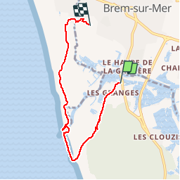
Tour Wandern von 5,8 km verfügbar auf Pays de la Loire, Vendée, Les Sables-d'Olonne. Diese Tour wird von nicolas.gx vorgeschlagen.
Beschreibung
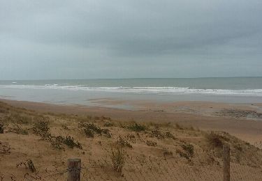
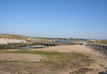
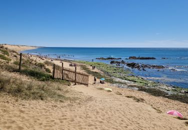
depart camping ocean direction la gachere, la plage des granges puis retour en suivant le gr
Ort
Land:
France
Region :
Pays de la Loire
Abteilung/Provinz :
Vendée
Kommune :
Les Sables-d'Olonne
Standort:
Olonne-sur-Mer
Gehen Sie:(Dec)
Gehen Sie:(UTM)
589324 ; 5160580 (30T) N.
Kommentare
Touren in der Umgebung
![Tour Mountainbike L'Île-d'Olonne - Les marais de l'île d'Olonne - Le Jaunay - Photo](https://media.geolcdn.com/t/375/260/ext.jpg?maxdim=2&url=https%3A%2F%2Fservices.sitytrail.com%2FGeolivesWS%2FDownloadMedia.ashx%3FTrailID%3D129690%26Media%3D13226_2.jpg)
![Mountainbike Mountainbike](https://static1.geolcdn.com/sitytour/trail-icons/202.png)
Les marais de l'île d'Olonne - Le Jaunay
Mountainbike
Schwierig
(2)
L'Île-d'Olonne,
Pays de la Loire,
Vendée,
France
![](/images/other/stat-length.png)
54 km | 63 km-effort
3h 30min
![](https://static1.geolcdn.com/siteimages/upload/files/16400158638029165_repeat_loop_refresh_sync_direction_icon.png)
Ja
![Tour Wandern L'Île-d'Olonne - Sentier la fleur de sel - Photo](https://media.geolcdn.com/t/375/260/1ccf5a45-c40a-4459-b03e-737e931f1f29.jpg&format=jpg&maxdim=2)
![Wandern Wandern](https://static1.geolcdn.com/sitytour/trail-icons/101.png)
Sentier la fleur de sel
Wandern
Sehr leicht
L'Île-d'Olonne,
Pays de la Loire,
Vendée,
France
![](/images/other/stat-length.png)
5 km | 5,3 km-effort
1h 4min
![](https://static1.geolcdn.com/siteimages/upload/files/16400158638029165_repeat_loop_refresh_sync_direction_icon.png)
Ja
![Tour Andere Aktivitäten Les Sables-d'Olonne - rando Dudu 05-01-2019 - Photo](https://media.geolcdn.com/t/375/260/ext.jpg?maxdim=2&url=https%3A%2F%2Fservices.sitytrail.com%2FGeolivesWS%2FDownloadMedia.ashx%3FTrailID%3D1092695%26Media%3D20190105170235.jpg)
![Andere Aktivitäten Andere Aktivitäten](https://static1.geolcdn.com/sitytour/trail-icons/900.png)
rando Dudu 05-01-2019
Andere Aktivitäten
Sehr leicht
Les Sables-d'Olonne,
Pays de la Loire,
Vendée,
France
![](/images/other/stat-length.png)
10,5 km | 11,5 km-effort
2h 19min
![](https://static1.geolcdn.com/siteimages/upload/files/16400158638029165_repeat_loop_refresh_sync_direction_icon.png)
Ja
![Tour Andere Aktivitäten Les Sables-d'Olonne - vert olonne - Photo](https://media.geolcdn.com/t/375/260/ext.jpg?maxdim=2&url=https%3A%2F%2Fservices.sitytrail.com%2FGeolivesWS%2FDownloadMedia.ashx%3FTrailID%3D684620%26Media%3Dfix__20170115104246.jpg)
![Andere Aktivitäten Andere Aktivitäten](https://static1.geolcdn.com/sitytour/trail-icons/900.png)
vert olonne
Andere Aktivitäten
Sehr leicht
Les Sables-d'Olonne,
Pays de la Loire,
Vendée,
France
![](/images/other/stat-length.png)
18,7 km | 21 km-effort
2h 5min
![](https://static1.geolcdn.com/siteimages/upload/files/16400158638029165_repeat_loop_refresh_sync_direction_icon.png)
Ja
![Tour Wandern Les Sables-d'Olonne - Forêt et Marais au Pays des Olonnes - Photo](https://media.geolcdn.com/t/375/260/ext.jpg?maxdim=2&url=https%3A%2F%2Fservices.sitytrail.com%2FGeolivesWS%2FDownloadMedia.ashx%3FTrailID%3D191330%26Media%3D14886_5.jpg)
![Wandern Wandern](https://static1.geolcdn.com/sitytour/trail-icons/101.png)
Forêt et Marais au Pays des Olonnes
Wandern
Medium
Les Sables-d'Olonne,
Pays de la Loire,
Vendée,
France
![](/images/other/stat-length.png)
15,3 km | 16,7 km-effort
3h 30min
![](https://static1.geolcdn.com/siteimages/upload/files/16400158638029165_repeat_loop_refresh_sync_direction_icon.png)
Ja
![Tour Wandern Les Sables-d'Olonne - Vendée_Sables-d'Olonne_Plage_de_Sauveterre - Photo](https://media.geolcdn.com/t/375/260/c681cc1a-daed-4477-9ef7-8159f743e858.jpg&format=jpg&maxdim=2)
![Wandern Wandern](https://static1.geolcdn.com/sitytour/trail-icons/101.png)
Vendée_Sables-d'Olonne_Plage_de_Sauveterre
Wandern
Sehr leicht
Les Sables-d'Olonne,
Pays de la Loire,
Vendée,
France
![](/images/other/stat-length.png)
4,6 km | 5,2 km-effort
1h 32min
![](https://static1.geolcdn.com/siteimages/upload/files/16400158638029165_repeat_loop_refresh_sync_direction_icon.png)
Ja
![Tour Wandern Les Sables-d'Olonne - Didi tanbouille - Photo](https://media.geolcdn.com/t/375/260/fe2891ef-a20d-4463-b030-d3d920b96253.jpg&format=jpg&maxdim=2)
![Wandern Wandern](https://static1.geolcdn.com/sitytour/trail-icons/101.png)
Didi tanbouille
Wandern
Sehr leicht
Les Sables-d'Olonne,
Pays de la Loire,
Vendée,
France
![](/images/other/stat-length.png)
8,1 km | 8,8 km-effort
1h 49min
![](https://static1.geolcdn.com/siteimages/upload/files/16400158638029165_repeat_loop_refresh_sync_direction_icon.png)
Ja
![Tour Wandern Les Sables-d'Olonne - Sentier Les Bourbes - Photo](https://media.geolcdn.com/t/375/260/16dadf7e-c56c-4289-a0bb-7fcf5a98618e.jpg&format=jpg&maxdim=2)
![Wandern Wandern](https://static1.geolcdn.com/sitytour/trail-icons/101.png)
Sentier Les Bourbes
Wandern
Einfach
Les Sables-d'Olonne,
Pays de la Loire,
Vendée,
France
![](/images/other/stat-length.png)
6,8 km | 7,4 km-effort
1h 40min
![](https://static1.geolcdn.com/siteimages/upload/files/16400158638029165_repeat_loop_refresh_sync_direction_icon.png)
Ja
![Tour Wandern Les Sables-d'Olonne - Circuit Champclou - Photo](https://media.geolcdn.com/t/375/260/1ce1689f-b1d5-4eb7-bc94-9b3b713436b7.jpg&format=jpg&maxdim=2)
![Wandern Wandern](https://static1.geolcdn.com/sitytour/trail-icons/101.png)
Circuit Champclou
Wandern
Les Sables-d'Olonne,
Pays de la Loire,
Vendée,
France
![](/images/other/stat-length.png)
10,4 km | 11,2 km-effort
2h 45min
![](https://static1.geolcdn.com/siteimages/upload/files/16400158638029165_repeat_loop_refresh_sync_direction_icon.png)
Ja