


11,3 km | 13,3 km-effort
![Tour Zu Fuß Leština u Světlé - [Ž] Zbraslavice - Leština u Světlé - Photo](https://media.geolcdn.com/t/1900/400/840dccec-9254-4f14-adb8-d32f4de9986b.jpeg&format=pjpeg&maxdim=2)

Tous les sentiers balisés d’Europe GUIDE+


Kostenlosegpshiking-Anwendung
 SityTrail
IGN / Geografische Institute
SityTrail World
Die Welt öffnet sich für Sie
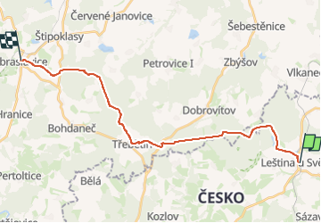
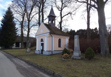
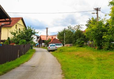
Tour Zu Fuß von 21 km verfügbar auf Südosten, Region Hochland, Leština u Světlé. Diese Tour wird von SityTrail - itinéraires balisés pédestres vorgeschlagen.
Tour erstellt von cz:KČT.
![Tour Zu Fuß Leština u Světlé - [Ž] Zbraslavice - Leština u Světlé - Photo 1](https://media.geolcdn.com/t/2048/auto/aced56cb-1b97-4a12-9e09-0f6026ef8f7e.jpeg&format=jpg&maxdim=0 "Tour Zu Fuß Leština u Světlé - [Ž] Zbraslavice - Leština u Světlé - Photo 1")
![Tour Zu Fuß Leština u Světlé - [Ž] Zbraslavice - Leština u Světlé - Photo 2](https://media.geolcdn.com/t/2048/auto/72d62baa-f39f-4631-bc00-48b562424f69.jpeg&format=jpg&maxdim=0 "Tour Zu Fuß Leština u Světlé - [Ž] Zbraslavice - Leština u Světlé - Photo 2")
![Tour Zu Fuß Leština u Světlé - [Ž] Zbraslavice - Leština u Světlé - Photo 3](https://media.geolcdn.com/t/2048/auto/6636646e-0e2c-4906-b2f3-7be9108148f2.jpeg&format=jpg&maxdim=0 "Tour Zu Fuß Leština u Světlé - [Ž] Zbraslavice - Leština u Světlé - Photo 3")
![Tour Zu Fuß Leština u Světlé - [Ž] Zbraslavice - Leština u Světlé - Photo 4](https://media.geolcdn.com/t/2048/auto/ae6014f9-9cdb-401b-943a-876fd7d7623b.jpeg&format=jpg&maxdim=0 "Tour Zu Fuß Leština u Světlé - [Ž] Zbraslavice - Leština u Světlé - Photo 4")
![Tour Zu Fuß Leština u Světlé - [Ž] Zbraslavice - Leština u Světlé - Photo 5](https://media.geolcdn.com/t/2048/auto/4806588e-aac3-4794-b32e-d179a0677d35.jpeg&format=jpg&maxdim=0 "Tour Zu Fuß Leština u Světlé - [Ž] Zbraslavice - Leština u Světlé - Photo 5")
![Tour Zu Fuß Leština u Světlé - [Ž] Zbraslavice - Leština u Světlé - Photo 6](https://media.geolcdn.com/t/2048/auto/be996853-0ce4-4f3a-8b69-e257e9c056c7.jpeg&format=jpg&maxdim=0 "Tour Zu Fuß Leština u Světlé - [Ž] Zbraslavice - Leština u Světlé - Photo 6")
![Tour Zu Fuß Leština u Světlé - [Ž] Zbraslavice - Leština u Světlé - Photo 7](https://media.geolcdn.com/t/2048/auto/2aa0f060-b390-4cb9-b8bc-e92c06caff84.jpeg&format=jpg&maxdim=0 "Tour Zu Fuß Leština u Světlé - [Ž] Zbraslavice - Leština u Světlé - Photo 7")
![Tour Zu Fuß Leština u Světlé - [Ž] Zbraslavice - Leština u Světlé - Photo 8](https://media.geolcdn.com/t/2048/auto/e47418a6-9fa1-49e6-9174-21ad7a65b2ca.jpeg&format=jpg&maxdim=0 "Tour Zu Fuß Leština u Světlé - [Ž] Zbraslavice - Leština u Světlé - Photo 8")
![Tour Zu Fuß Leština u Světlé - [Ž] Zbraslavice - Leština u Světlé - Photo 9](https://media.geolcdn.com/t/2048/auto/2fa5e36d-4f1f-4ba6-b4b6-b867e5e3a913.jpeg&format=jpg&maxdim=0 "Tour Zu Fuß Leština u Světlé - [Ž] Zbraslavice - Leština u Světlé - Photo 9")
![Tour Zu Fuß Leština u Světlé - [Ž] Zbraslavice - Leština u Světlé - Photo 10](https://media.geolcdn.com/t/2048/auto/840dccec-9254-4f14-adb8-d32f4de9986b.jpeg&format=jpg&maxdim=0 "Tour Zu Fuß Leština u Světlé - [Ž] Zbraslavice - Leština u Světlé - Photo 10")
![Tour Zu Fuß Tschaslau - [Z] Čáslav - Pod Tisou skálou - Photo](https://media.geolcdn.com/t/375/260/946bc21c-d4b8-4dc3-b551-c6568a399953.jpeg&format=jpg&maxdim=2)
Zu Fuß
![Tour Zu Fuß Vápenný Podol - [Z] Vápenný Podol - Lovětínská rokle - Photo](https://media.geolcdn.com/t/375/260/ed4a2dcc-90b9-41d4-a6f1-952f7b0de326.jpeg&format=jpg&maxdim=2)
Zu Fuß
![Tour Zu Fuß Chlístovice - [M] Kutná Hora - Sion - Photo](https://media.geolcdn.com/t/375/260/f7bd726a-99e7-4337-aabf-16f555628678.jpeg&format=jpg&maxdim=2)
Zu Fuß
![Tour Zu Fuß Zbraslavice - [M] Bahno - Kácov - Photo](https://media.geolcdn.com/t/375/260/2fff3c16-8a66-4c03-8304-9608f478251f.jpeg&format=jpg&maxdim=2)
Zu Fuß
![Tour Zu Fuß Běstvina - [Z] Běstvina - Seč - Photo](https://media.geolcdn.com/t/375/260/1fe36d45-751d-4c3f-8910-968f469449fc.jpeg&format=jpg&maxdim=2)
Zu Fuß
![Tour Zu Fuß Tremoschnitz - [Ž] Údolím Doubravy (Pařížov - Třemošnice) - Photo](https://media.geolcdn.com/t/375/260/128e315c-4870-4181-9cde-93bc9f6c90c5.jpeg&format=jpg&maxdim=2)
Zu Fuß
Zu Fuß
Zu Fuß
![Tour Zu Fuß Knyk - [Z] Havlíčkův Brod - Rozňák - Photo](https://media.geolcdn.com/t/375/260/535a2752-5f55-42c5-bb45-cbdaadba2019.jpeg&format=jpg&maxdim=2)
Zu Fuß