![](/images/other/stat-length.png)
![Tour Zu Fuß Nové Syrovice - Graselova stezka - Nové Syrovice - Photo](https://media.geolcdn.com/t/1900/400/79fd8a9f-d981-40e0-8f46-c0e47c32de2c.jpeg&format=pjpeg&maxdim=2)
Graselova stezka - Nové Syrovice
SityTrail - itinéraires balisés pédestres
Tous les sentiers balisés d’Europe GUIDE+
![Länge](/images/other/stat-length.png)
Länge
9,1 km
![Maximale Höhe](https://static1.geolcdn.com/siteimages/upload/files/1508320355ic_sort_altitude_max_24dp.png)
Maximale Höhe
497 m
![Positive Höhendifferenz](https://static1.geolcdn.com/siteimages/upload/files/1508320355ic_sort_den_pos_24dp.png)
Positive Höhendifferenz
149 m
![Km-Effort](/images/other/stat-length.png)
Km-Effort
11 km
![Min. Höhe](https://static1.geolcdn.com/siteimages/upload/files/1508320355ic_sort_altitude_min_24dp.png)
Min. Höhe
430 m
![Negative Höhendifferenz](https://static1.geolcdn.com/siteimages/upload/files/1508320355ic_sort_den_neg_24dp.png)
Negative Höhendifferenz
130 m
![Boucle](https://static1.geolcdn.com/siteimages/upload/files/16400158638029165_repeat_loop_refresh_sync_direction_icon.png)
Boucle
Nein
Kennzeichnung
Erstellungsdatum :
2025-02-07 17:25:09.333
Letzte Änderung :
2025-02-07 17:25:09.333
![Zu Fuß](https://static1.geolcdn.com/sitytour/trail-icons/100.png)
2h30
Schwierigkeit : Einfach
![Scannen Sie diesen QR-Code, um die Tour in der SityTrail-Anwendung zu öffnen](https://capi.geolives.com/qq0zvz2zws4bq2lad0pu/sitytour/trails/4346362/qr.png?size=200)
Kostenlosegpshiking-Anwendung
Über SityTrail
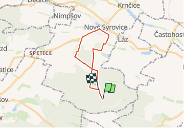
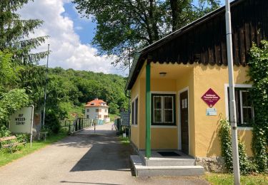
Tour Zu Fuß von 9,1 km verfügbar auf Südosten, Region Hochland, Nové Syrovice. Diese Tour wird von SityTrail - itinéraires balisés pédestres vorgeschlagen.
Beschreibung
Tour erstellt von cz:KČT.
Ort
Land:
Czech Republic
Region :
Südosten
Abteilung/Provinz :
Region Hochland
Kommune :
Nové Syrovice
Standort:
Unknown
Gehen Sie:(Dec)
Gehen Sie:(UTM)
556445 ; 5426147 (33U) N.
Kommentare
Touren in der Umgebung
![Tour Zu Fuß Windschau / Hanasow - NS Karla Claryho - Photo](https://media.geolcdn.com/t/375/260/3ebb76a8-92c2-4bef-81de-0753f94a5be8.jpeg&format=jpg&maxdim=2)
![Zu Fuß Zu Fuß](https://static1.geolcdn.com/sitytour/trail-icons/100.png)
NS Karla Claryho
Zu Fuß
Einfach
Windschau / Hanasow,
Südosten,
Südmährische Region,
Czech Republic
![](/images/other/stat-length.png)
3,5 km | 5,1 km-effort
1h 9min
![](https://static1.geolcdn.com/siteimages/upload/files/16400158638029165_repeat_loop_refresh_sync_direction_icon.png)
Nein
![Tour Zu Fuß Vöttau - [Č] Bítov - hrad Bítov - Photo](https://media.geolcdn.com/t/375/260/dec2ab92-0755-4f9b-9601-6be8ada20293.jpeg&format=jpg&maxdim=2)
![Zu Fuß Zu Fuß](https://static1.geolcdn.com/sitytour/trail-icons/100.png)
[Č] Bítov - hrad Bítov
Zu Fuß
Einfach
Vöttau,
Südosten,
Südmährische Region,
Czech Republic
![](/images/other/stat-length.png)
3,3 km | 4,9 km-effort
1h 6min
![](https://static1.geolcdn.com/siteimages/upload/files/16400158638029165_repeat_loop_refresh_sync_direction_icon.png)
Nein
![Tour Zu Fuß Liliendorf - [Ž] Lesná - Ledové sluje - vyhlídka - Photo](https://media.geolcdn.com/t/375/260/ac13b2a6-a2a6-49b6-b151-4f6483ad5d2b.jpeg&format=jpg&maxdim=2)
![Zu Fuß Zu Fuß](https://static1.geolcdn.com/sitytour/trail-icons/100.png)
[Ž] Lesná - Ledové sluje - vyhlídka
Zu Fuß
Einfach
Liliendorf,
Südosten,
Südmährische Region,
Czech Republic
![](/images/other/stat-length.png)
3,3 km | 4,2 km-effort
56min
![](https://static1.geolcdn.com/siteimages/upload/files/16400158638029165_repeat_loop_refresh_sync_direction_icon.png)
Nein
![Tour Zu Fuß Schönwald - [M] Šumná - Hardegg - Photo](https://media.geolcdn.com/t/375/260/57463325-aa2b-454f-9571-0eca5929e103.jpeg&format=jpg&maxdim=2)
![Zu Fuß Zu Fuß](https://static1.geolcdn.com/sitytour/trail-icons/100.png)
[M] Šumná - Hardegg
Zu Fuß
Einfach
Schönwald,
Südosten,
Südmährische Region,
Czech Republic
![](/images/other/stat-length.png)
11,2 km | 13,5 km-effort
3h 3min
![](https://static1.geolcdn.com/siteimages/upload/files/16400158638029165_repeat_loop_refresh_sync_direction_icon.png)
Nein
![Tour Zu Fuß Frain an der Thaya - Cesta Heleny Mniszkové - Photo](https://media.geolcdn.com/t/375/260/e25aa64b-3028-4ec5-9b76-fe71ec93487f.jpeg&format=jpg&maxdim=2)
![Zu Fuß Zu Fuß](https://static1.geolcdn.com/sitytour/trail-icons/100.png)
Cesta Heleny Mniszkové
Zu Fuß
Einfach
Frain an der Thaya,
Südosten,
Südmährische Region,
Czech Republic
![](/images/other/stat-length.png)
3 km | 3,8 km-effort
52min
![](https://static1.geolcdn.com/siteimages/upload/files/16400158638029165_repeat_loop_refresh_sync_direction_icon.png)
Ja
![Tour Zu Fuß Frain an der Thaya - [Ž] Vranov nad Dyjí - okruh - Photo](https://media.geolcdn.com/t/375/260/59f7bd35-0996-4a8b-b4dd-9275df0a0590.jpeg&format=jpg&maxdim=2)
![Zu Fuß Zu Fuß](https://static1.geolcdn.com/sitytour/trail-icons/100.png)
[Ž] Vranov nad Dyjí - okruh
Zu Fuß
Einfach
Frain an der Thaya,
Südosten,
Südmährische Region,
Czech Republic
![](/images/other/stat-length.png)
5,2 km | 6,9 km-effort
1h 34min
![](https://static1.geolcdn.com/siteimages/upload/files/16400158638029165_repeat_loop_refresh_sync_direction_icon.png)
Ja
![Tour Zu Fuß Gemeinde Hardegg - Thayatalweg - Variante Umlaufberg - Photo](https://media.geolcdn.com/t/375/260/326db0a5-6132-482d-abe4-8765d8caf223.jpeg&format=jpg&maxdim=2)
![Zu Fuß Zu Fuß](https://static1.geolcdn.com/sitytour/trail-icons/100.png)
Thayatalweg - Variante Umlaufberg
Zu Fuß
Einfach
Gemeinde Hardegg,
Niederösterreich,
Bezirk Hollabrunn,
Austria
![](/images/other/stat-length.png)
8,8 km | 11,9 km-effort
2h 42min
![](https://static1.geolcdn.com/siteimages/upload/files/16400158638029165_repeat_loop_refresh_sync_direction_icon.png)
Nein
![Tour Zu Fuß Gemeinde Hardegg - [M] Vranov nad Dyjí - Felling - Photo](https://media.geolcdn.com/t/375/260/e25aa64b-3028-4ec5-9b76-fe71ec93487f.jpeg&format=jpg&maxdim=2)
![Zu Fuß Zu Fuß](https://static1.geolcdn.com/sitytour/trail-icons/100.png)
[M] Vranov nad Dyjí - Felling
Zu Fuß
Einfach
Gemeinde Hardegg,
Niederösterreich,
Bezirk Hollabrunn,
Austria
![](/images/other/stat-length.png)
5,5 km | 6,2 km-effort
1h 25min
![](https://static1.geolcdn.com/siteimages/upload/files/16400158638029165_repeat_loop_refresh_sync_direction_icon.png)
Nein
![Tour Zu Fuß Gemeinde Raabs an der Thaya - AT-71 - Photo](https://media.geolcdn.com/t/375/260/2ad5610b-812f-4e89-8608-92b0ede35bd6.jpeg&format=jpg&maxdim=2)
![Zu Fuß Zu Fuß](https://static1.geolcdn.com/sitytour/trail-icons/100.png)
AT-71
Zu Fuß
Einfach
Gemeinde Raabs an der Thaya,
Niederösterreich,
Bezirk Waidhofen an der Thaya,
Austria
![](/images/other/stat-length.png)
4,6 km | 6,5 km-effort
1h 28min
![](https://static1.geolcdn.com/siteimages/upload/files/16400158638029165_repeat_loop_refresh_sync_direction_icon.png)
Nein