![](/images/other/stat-length.png)
![Tour Zu Fuß Unknown - Tršće - Sveta gora - Die Quelle der Kupa - Crni Lug - Photo](https://media.geolcdn.com/t/1900/400/60013492-baa6-4369-bcba-b910bef47edc.jpeg&format=pjpeg&maxdim=2)
Tršće - Sveta gora - Die Quelle der Kupa - Crni Lug
SityTrail - itinéraires balisés pédestres
Tous les sentiers balisés d’Europe GUIDE+
![Länge](/images/other/stat-length.png)
![Maximale Höhe](https://static1.geolcdn.com/siteimages/upload/files/1508320355ic_sort_altitude_max_24dp.png)
![Positive Höhendifferenz](https://static1.geolcdn.com/siteimages/upload/files/1508320355ic_sort_den_pos_24dp.png)
![Km-Effort](/images/other/stat-length.png)
![Min. Höhe](https://static1.geolcdn.com/siteimages/upload/files/1508320355ic_sort_altitude_min_24dp.png)
![Negative Höhendifferenz](https://static1.geolcdn.com/siteimages/upload/files/1508320355ic_sort_den_neg_24dp.png)
![Boucle](https://static1.geolcdn.com/siteimages/upload/files/16400158638029165_repeat_loop_refresh_sync_direction_icon.png)
![Zu Fuß](https://static1.geolcdn.com/sitytour/trail-icons/100.png)
5h25
Schwierigkeit : Medium
![Scannen Sie diesen QR-Code, um die Tour in der SityTrail-Anwendung zu öffnen](https://capi.geolives.com/qq0zvz2zws4bq2lad0pu/sitytour/trails/4346118/qr.png?size=200)
Kostenlosegpshiking-Anwendung
Über SityTrail
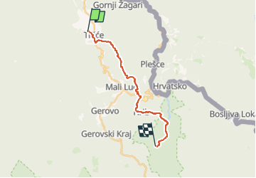
Tour Zu Fuß von 15,3 km verfügbar auf Unbekannt, Primorsko-goranska županija. Diese Tour wird von SityTrail - itinéraires balisés pédestres vorgeschlagen.
Beschreibung
In the area from Tršće to Risnjak National Park, Via Dinarica follows the route of Gorski Kotar Hiking Trail. The trail is well kept and maintained. From Tršće, we first need to climb to the village of Kraljev Vrh by road. From there, we then continue by following the hiking trail markings ...
Website: https://trail.viadinarica.com/tour/hiking/15948208/
Ort
Kommentare
Touren in der Umgebung
![Tour Zu Fuß - Prezid - Čabar - Tršće - Photo](https://media.geolcdn.com/t/375/260/63396e8a-0219-4975-8a92-2dc12ba77793.jpeg&format=jpg&maxdim=2)
![Zu Fuß Zu Fuß](https://static1.geolcdn.com/sitytour/trail-icons/100.png)
Zu Fuß
![](/images/other/stat-length.png)
![](https://static1.geolcdn.com/siteimages/upload/files/16400158638029165_repeat_loop_refresh_sync_direction_icon.png)