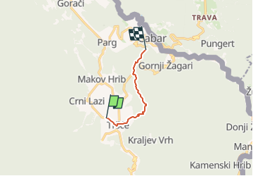
![](/images/other/stat-length.png)
![Tour Zu Fuß Unknown - Prezid - Čabar - Tršće - Photo](https://media.geolcdn.com/t/1900/400/63396e8a-0219-4975-8a92-2dc12ba77793.jpeg&format=pjpeg&maxdim=2)
Prezid - Čabar - Tršće
SityTrail - itinéraires balisés pédestres
Tous les sentiers balisés d’Europe GUIDE+
![Länge](/images/other/stat-length.png)
![Maximale Höhe](https://static1.geolcdn.com/siteimages/upload/files/1508320355ic_sort_altitude_max_24dp.png)
![Positive Höhendifferenz](https://static1.geolcdn.com/siteimages/upload/files/1508320355ic_sort_den_pos_24dp.png)
![Km-Effort](/images/other/stat-length.png)
![Min. Höhe](https://static1.geolcdn.com/siteimages/upload/files/1508320355ic_sort_altitude_min_24dp.png)
![Negative Höhendifferenz](https://static1.geolcdn.com/siteimages/upload/files/1508320355ic_sort_den_neg_24dp.png)
![Boucle](https://static1.geolcdn.com/siteimages/upload/files/16400158638029165_repeat_loop_refresh_sync_direction_icon.png)
![Zu Fuß](https://static1.geolcdn.com/sitytour/trail-icons/100.png)
1h36
Schwierigkeit : Einfach
![Scannen Sie diesen QR-Code, um die Tour in der SityTrail-Anwendung zu öffnen](https://capi.geolives.com/qq0zvz2zws4bq2lad0pu/sitytour/trails/4346116/qr.png?size=200)
Kostenlosegpshiking-Anwendung
Über SityTrail
Tour Zu Fuß von 4,9 km verfügbar auf Unbekannt, Primorsko-goranska županija. Diese Tour wird von SityTrail - itinéraires balisés pédestres vorgeschlagen.
Beschreibung
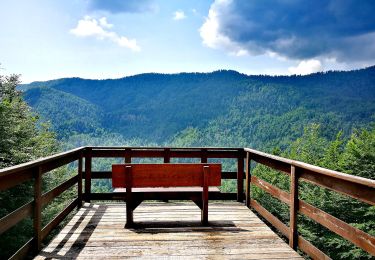
In the northern part of the region of Gorski kotar, north of the mountain area of Risnjak and the city of Delnice, there is a mountainous and forested area with the settlements of Gerovo, Čabar and Prezid as key centers. This area offers a sight of the most beautiful mountain oasis in that part ...
Website: https://trail.viadinarica.com/tour/hiking/15085364/
Ort
Kommentare
Touren in der Umgebung
![Tour Zu Fuß - Tršće - Sveta gora - Die Quelle der Kupa - Crni Lug - Photo](https://media.geolcdn.com/t/375/260/60013492-baa6-4369-bcba-b910bef47edc.jpeg&format=jpg&maxdim=2)
![Zu Fuß Zu Fuß](https://static1.geolcdn.com/sitytour/trail-icons/100.png)
Zu Fuß
![](/images/other/stat-length.png)
![](https://static1.geolcdn.com/siteimages/upload/files/16400158638029165_repeat_loop_refresh_sync_direction_icon.png)