![](/images/other/stat-length.png)
![Tour Zu Fuß Olbersdorf - Vycházková stezka Dubí - Photo](https://media.geolcdn.com/t/1900/400/2caedeca-8910-4700-9920-42d9b6158781.jpeg&format=pjpeg&maxdim=2)
Vycházková stezka Dubí
SityTrail - itinéraires balisés pédestres
Tous les sentiers balisés d’Europe GUIDE+
![Länge](/images/other/stat-length.png)
Länge
3,4 km
![Maximale Höhe](https://static1.geolcdn.com/siteimages/upload/files/1508320355ic_sort_altitude_max_24dp.png)
Maximale Höhe
543 m
![Positive Höhendifferenz](https://static1.geolcdn.com/siteimages/upload/files/1508320355ic_sort_den_pos_24dp.png)
Positive Höhendifferenz
111 m
![Km-Effort](/images/other/stat-length.png)
Km-Effort
5,1 km
![Min. Höhe](https://static1.geolcdn.com/siteimages/upload/files/1508320355ic_sort_altitude_min_24dp.png)
Min. Höhe
419 m
![Negative Höhendifferenz](https://static1.geolcdn.com/siteimages/upload/files/1508320355ic_sort_den_neg_24dp.png)
Negative Höhendifferenz
172 m
![Boucle](https://static1.geolcdn.com/siteimages/upload/files/16400158638029165_repeat_loop_refresh_sync_direction_icon.png)
Boucle
Ja
Kennzeichnung
Erstellungsdatum :
2025-02-07 15:22:29.634
Letzte Änderung :
2025-02-07 15:22:29.634
![Zu Fuß](https://static1.geolcdn.com/sitytour/trail-icons/100.png)
1h09
Schwierigkeit : Einfach
![Scannen Sie diesen QR-Code, um die Tour in der SityTrail-Anwendung zu öffnen](https://capi.geolives.com/qq0zvz2zws4bq2lad0pu/sitytour/trails/4345999/qr.png?size=200)
Kostenlosegpshiking-Anwendung
Über SityTrail
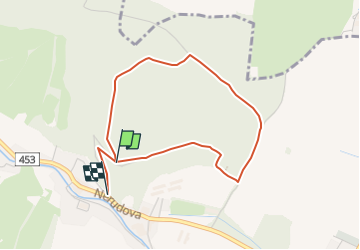
Tour Zu Fuß von 3,4 km verfügbar auf Mährisch-Schlesien, Mährisch-Schlesische Region, Olbersdorf. Diese Tour wird von SityTrail - itinéraires balisés pédestres vorgeschlagen.
Beschreibung
Tour erstellt von mesto-albrechtice.cz.
Ort
Land:
Czech Republic
Region :
Mährisch-Schlesien
Abteilung/Provinz :
Mährisch-Schlesische Region
Kommune :
Olbersdorf
Standort:
Unknown
Gehen Sie:(Dec)
Gehen Sie:(UTM)
682484 ; 5561031 (33U) N.
Kommentare
Touren in der Umgebung
![Tour Zu Fuß Olbersdorf - [Ž] Albrechtice - Petrovy boudy - Photo](https://media.geolcdn.com/t/375/260/f4747928-09d6-4159-b288-1d744968c1cc.jpeg&format=jpg&maxdim=2)
![Zu Fuß Zu Fuß](https://static1.geolcdn.com/sitytour/trail-icons/100.png)
[Ž] Albrechtice - Petrovy boudy
Zu Fuß
Schwierig
Olbersdorf,
Mährisch-Schlesien,
Mährisch-Schlesische Region,
Czech Republic
![](/images/other/stat-length.png)
22 km | 33 km-effort
7h 25min
![](https://static1.geolcdn.com/siteimages/upload/files/16400158638029165_repeat_loop_refresh_sync_direction_icon.png)
Nein
![Tour Zu Fuß Olbersdorf - Graniczny wierch - Photo](https://media.geolcdn.com/t/375/260/968f039a-78cd-4c88-a657-b1b03f367805.jpeg&format=jpg&maxdim=2)
![Zu Fuß Zu Fuß](https://static1.geolcdn.com/sitytour/trail-icons/100.png)
Graniczny wierch
Zu Fuß
Einfach
Olbersdorf,
Mährisch-Schlesien,
Mährisch-Schlesische Region,
Czech Republic
![](/images/other/stat-length.png)
3,3 km | 4,1 km-effort
55min
![](https://static1.geolcdn.com/siteimages/upload/files/16400158638029165_repeat_loop_refresh_sync_direction_icon.png)
Nein
![Tour Zu Fuß Olbersdorf - Městský turistický okruh - Photo](https://media.geolcdn.com/t/375/260/481acb77-f957-4345-883b-55b042e9bf6a.jpeg&format=jpg&maxdim=2)
![Zu Fuß Zu Fuß](https://static1.geolcdn.com/sitytour/trail-icons/100.png)
Městský turistický okruh
Zu Fuß
Schwierig
Olbersdorf,
Mährisch-Schlesien,
Mährisch-Schlesische Region,
Czech Republic
![](/images/other/stat-length.png)
27 km | 37 km-effort
8h 27min
![](https://static1.geolcdn.com/siteimages/upload/files/16400158638029165_repeat_loop_refresh_sync_direction_icon.png)
Nein