![](/images/other/stat-length.png)
![Tour Zu Fuß Chaloupek - Naučná stezka Okolím Komárova - Photo](https://media.geolcdn.com/t/1900/400/a9a24262-ae95-485e-bfa3-d3003fbe9896.jpeg&format=pjpeg&maxdim=2)
Naučná stezka Okolím Komárova
SityTrail - itinéraires balisés pédestres
Tous les sentiers balisés d’Europe GUIDE+
![Länge](/images/other/stat-length.png)
Länge
9,7 km
![Maximale Höhe](https://static1.geolcdn.com/siteimages/upload/files/1508320355ic_sort_altitude_max_24dp.png)
Maximale Höhe
529 m
![Positive Höhendifferenz](https://static1.geolcdn.com/siteimages/upload/files/1508320355ic_sort_den_pos_24dp.png)
Positive Höhendifferenz
217 m
![Km-Effort](/images/other/stat-length.png)
Km-Effort
12,6 km
![Min. Höhe](https://static1.geolcdn.com/siteimages/upload/files/1508320355ic_sort_altitude_min_24dp.png)
Min. Höhe
399 m
![Negative Höhendifferenz](https://static1.geolcdn.com/siteimages/upload/files/1508320355ic_sort_den_neg_24dp.png)
Negative Höhendifferenz
217 m
![Boucle](https://static1.geolcdn.com/siteimages/upload/files/16400158638029165_repeat_loop_refresh_sync_direction_icon.png)
Boucle
Ja
Kennzeichnung
Erstellungsdatum :
2025-02-07 14:23:15.625
Letzte Änderung :
2025-02-07 14:23:15.625
![Zu Fuß](https://static1.geolcdn.com/sitytour/trail-icons/100.png)
2h51
Schwierigkeit : Einfach
![Scannen Sie diesen QR-Code, um die Tour in der SityTrail-Anwendung zu öffnen](https://capi.geolives.com/qq0zvz2zws4bq2lad0pu/sitytour/trails/4345844/qr.png?size=200)
Kostenlosegpshiking-Anwendung
Über SityTrail
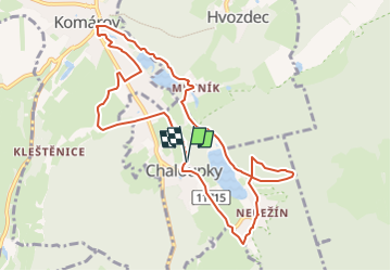
Tour Zu Fuß von 9,7 km verfügbar auf Mittelböhmen, Unbekannt, Chaloupek. Diese Tour wird von SityTrail - itinéraires balisés pédestres vorgeschlagen.
Beschreibung
Tour erstellt von cz:KČT.
Ort
Land:
Czech Republic
Region :
Mittelböhmen
Abteilung/Provinz :
Unbekannt
Kommune :
Chaloupek
Standort:
Unknown
Gehen Sie:(Dec)
Gehen Sie:(UTM)
418841 ; 5516134 (33U) N.
Kommentare
Touren in der Umgebung
![Tour Zu Fuß Horschowitz - [Z] Svatá Dobrotivá - Hořovice - Photo](https://media.geolcdn.com/t/375/260/ea1580be-866c-4304-b5b3-248e35399a46.jpeg&format=jpg&maxdim=2)
![Zu Fuß Zu Fuß](https://static1.geolcdn.com/sitytour/trail-icons/100.png)
[Z] Svatá Dobrotivá - Hořovice
Zu Fuß
Einfach
Horschowitz,
Mittelböhmen,
Unbekannt,
Czech Republic
![](/images/other/stat-length.png)
10,8 km | 14,3 km-effort
3h 14min
![](https://static1.geolcdn.com/siteimages/upload/files/16400158638029165_repeat_loop_refresh_sync_direction_icon.png)
Nein
![Tour Zu Fuß Hasenhof - [Ž] Svatá Dobrotivá - Kařízek - Photo](https://media.geolcdn.com/t/375/260/e689d382-4d8c-4668-997a-46922ae34690.jpeg&format=jpg&maxdim=2)
![Zu Fuß Zu Fuß](https://static1.geolcdn.com/sitytour/trail-icons/100.png)
[Ž] Svatá Dobrotivá - Kařízek
Zu Fuß
Einfach
Hasenhof,
Mittelböhmen,
Unbekannt,
Czech Republic
![](/images/other/stat-length.png)
7,1 km | 10,3 km-effort
2h 20min
![](https://static1.geolcdn.com/siteimages/upload/files/16400158638029165_repeat_loop_refresh_sync_direction_icon.png)
Nein
![Tour Zu Fuß Aujest - [Č] Strašice-Kařízek - Photo](https://media.geolcdn.com/t/375/260/29a7adf3-4cb7-4d97-ae5b-a34c7c58c20b.jpeg&format=jpg&maxdim=2)
![Zu Fuß Zu Fuß](https://static1.geolcdn.com/sitytour/trail-icons/100.png)
[Č] Strašice-Kařízek
Zu Fuß
Einfach
Aujest,
Mittelböhmen,
Unbekannt,
Czech Republic
![](/images/other/stat-length.png)
12,4 km | 15,8 km-effort
3h 35min
![](https://static1.geolcdn.com/siteimages/upload/files/16400158638029165_repeat_loop_refresh_sync_direction_icon.png)
Nein
![Tour Zu Fuß Podluch - [Ž] Záskalská - Podluhy - Photo](https://media.geolcdn.com/t/375/260/0f50dbf5-b8cd-4c30-b30b-06b149d63540.jpeg&format=jpg&maxdim=2)
![Zu Fuß Zu Fuß](https://static1.geolcdn.com/sitytour/trail-icons/100.png)
[Ž] Záskalská - Podluhy
Zu Fuß
Einfach
Podluch,
Mittelböhmen,
Unbekannt,
Czech Republic
![](/images/other/stat-length.png)
9,2 km | 12,4 km-effort
2h 48min
![](https://static1.geolcdn.com/siteimages/upload/files/16400158638029165_repeat_loop_refresh_sync_direction_icon.png)
Nein
![Tour Zu Fuß Hasenhof - [Ž] Strašice - Svatá Dobrotivá - Photo](https://media.geolcdn.com/t/375/260/50055e21-f702-4aa6-a720-57373c831aaf.jpeg&format=jpg&maxdim=2)
![Zu Fuß Zu Fuß](https://static1.geolcdn.com/sitytour/trail-icons/100.png)
[Ž] Strašice - Svatá Dobrotivá
Zu Fuß
Einfach
Hasenhof,
Mittelböhmen,
Unbekannt,
Czech Republic
![](/images/other/stat-length.png)
12 km | 14,7 km-effort
3h 20min
![](https://static1.geolcdn.com/siteimages/upload/files/16400158638029165_repeat_loop_refresh_sync_direction_icon.png)
Nein
![Tour Zu Fuß Hasenhof - [Z] Dolní Kvaň - Dlouhý vrch - Photo](https://media.geolcdn.com/t/375/260/561bc882-a328-4ea0-8534-a2cb9c7ea26e.jpeg&format=jpg&maxdim=2)
![Zu Fuß Zu Fuß](https://static1.geolcdn.com/sitytour/trail-icons/100.png)
[Z] Dolní Kvaň - Dlouhý vrch
Zu Fuß
Einfach
Hasenhof,
Mittelböhmen,
Unbekannt,
Czech Republic
![](/images/other/stat-length.png)
5,3 km | 8,3 km-effort
1h 52min
![](https://static1.geolcdn.com/siteimages/upload/files/16400158638029165_repeat_loop_refresh_sync_direction_icon.png)
Nein
![Tour Zu Fuß Hasenhof - [M] Svatá Dobrotivá - Jinecká Baština - Photo](https://media.geolcdn.com/t/375/260/95743070-4377-4cd6-b1fb-a3d2ccd0ea74.jpeg&format=jpg&maxdim=2)
![Zu Fuß Zu Fuß](https://static1.geolcdn.com/sitytour/trail-icons/100.png)
[M] Svatá Dobrotivá - Jinecká Baština
Zu Fuß
Einfach
Hasenhof,
Mittelböhmen,
Unbekannt,
Czech Republic
![](/images/other/stat-length.png)
5,3 km | 8,2 km-effort
1h 51min
![](https://static1.geolcdn.com/siteimages/upload/files/16400158638029165_repeat_loop_refresh_sync_direction_icon.png)
Nein
![Tour Zu Fuß Chaloupek - [Ž] Chaloupky - U Bílého křížku - Photo](https://media.geolcdn.com/t/375/260/e7e94d6a-38a9-41b7-9c61-4b5e41f5448c.jpeg&format=jpg&maxdim=2)
![Zu Fuß Zu Fuß](https://static1.geolcdn.com/sitytour/trail-icons/100.png)
[Ž] Chaloupky - U Bílého křížku
Zu Fuß
Einfach
Chaloupek,
Mittelböhmen,
Unbekannt,
Czech Republic
![](/images/other/stat-length.png)
6,3 km | 8,7 km-effort
1h 58min
![](https://static1.geolcdn.com/siteimages/upload/files/16400158638029165_repeat_loop_refresh_sync_direction_icon.png)
Nein
![Tour Zu Fuß Aujest - [Ž] Kařízek - Týček - Photo](https://media.geolcdn.com/t/375/260/e4e16ae0-b46d-45a5-803c-c3b46f9d7a1e.jpeg&format=jpg&maxdim=2)
![Zu Fuß Zu Fuß](https://static1.geolcdn.com/sitytour/trail-icons/100.png)
[Ž] Kařízek - Týček
Zu Fuß
Einfach
Aujest,
Mittelböhmen,
Unbekannt,
Czech Republic
![](/images/other/stat-length.png)
10,7 km | 13,3 km-effort
3h 2min
![](https://static1.geolcdn.com/siteimages/upload/files/16400158638029165_repeat_loop_refresh_sync_direction_icon.png)
Nein