![](/images/other/stat-length.png)
![Tour Zu Fuß Bezděkov - Spiessova NS - Photo](https://media.geolcdn.com/t/1900/400/4e027b20-fb20-4756-95b3-8721b326a4bd.jpeg&format=pjpeg&maxdim=2)
Spiessova NS
SityTrail - itinéraires balisés pédestres
Tous les sentiers balisés d’Europe GUIDE+
![Länge](/images/other/stat-length.png)
Länge
13,8 km
![Maximale Höhe](https://static1.geolcdn.com/siteimages/upload/files/1508320355ic_sort_altitude_max_24dp.png)
Maximale Höhe
637 m
![Positive Höhendifferenz](https://static1.geolcdn.com/siteimages/upload/files/1508320355ic_sort_den_pos_24dp.png)
Positive Höhendifferenz
317 m
![Km-Effort](/images/other/stat-length.png)
Km-Effort
18 km
![Min. Höhe](https://static1.geolcdn.com/siteimages/upload/files/1508320355ic_sort_altitude_min_24dp.png)
Min. Höhe
410 m
![Negative Höhendifferenz](https://static1.geolcdn.com/siteimages/upload/files/1508320355ic_sort_den_neg_24dp.png)
Negative Höhendifferenz
320 m
![Boucle](https://static1.geolcdn.com/siteimages/upload/files/16400158638029165_repeat_loop_refresh_sync_direction_icon.png)
Boucle
Ja
Kennzeichnung
Erstellungsdatum :
2025-02-07 13:44:29.599
Letzte Änderung :
2025-02-07 13:44:29.599
![Zu Fuß](https://static1.geolcdn.com/sitytour/trail-icons/100.png)
4h05
Schwierigkeit : Einfach
![Scannen Sie diesen QR-Code, um die Tour in der SityTrail-Anwendung zu öffnen](https://capi.geolives.com/qq0zvz2zws4bq2lad0pu/sitytour/trails/4345727/qr.png?size=200)
Kostenlosegpshiking-Anwendung
Über SityTrail
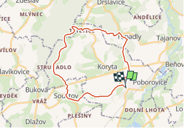
Tour Zu Fuß von 13,8 km verfügbar auf Südwesten, Pilsner Region, Bezděkov. Diese Tour wird von SityTrail - itinéraires balisés pédestres vorgeschlagen.
Beschreibung
Tour erstellt von cz:KČT.
Ort
Land:
Czech Republic
Region :
Südwesten
Abteilung/Provinz :
Pilsner Region
Kommune :
Bezděkov
Standort:
Unknown
Gehen Sie:(Dec)
Gehen Sie:(UTM)
371281 ; 5471303 (33U) N.
Kommentare
Touren in der Umgebung
![Tour Zu Fuß Lettin - [Ž] Bzí - Svárkov - Photo](https://media.geolcdn.com/t/375/260/e4fcdbd7-7501-40ad-9c2a-0022772a1930.jpeg&format=jpg&maxdim=2)
![Zu Fuß Zu Fuß](https://static1.geolcdn.com/sitytour/trail-icons/100.png)
[Ž] Bzí - Svárkov
Zu Fuß
Einfach
Lettin,
Südwesten,
Pilsner Region,
Czech Republic
![](/images/other/stat-length.png)
3,7 km | 4,9 km-effort
1h 6min
![](https://static1.geolcdn.com/siteimages/upload/files/16400158638029165_repeat_loop_refresh_sync_direction_icon.png)
Nein
![Tour Zu Fuß Klattau - Klatovský vycházkový okruh - Photo](https://media.geolcdn.com/t/375/260/c2bdaf4f-2e51-4ed0-8119-43d147205574.jpeg&format=jpg&maxdim=2)
![Zu Fuß Zu Fuß](https://static1.geolcdn.com/sitytour/trail-icons/100.png)
Klatovský vycházkový okruh
Zu Fuß
Einfach
Klattau,
Südwesten,
Pilsner Region,
Czech Republic
![](/images/other/stat-length.png)
12,1 km | 15,2 km-effort
3h 27min
![](https://static1.geolcdn.com/siteimages/upload/files/16400158638029165_repeat_loop_refresh_sync_direction_icon.png)
Nein
![Tour Zu Fuß Neuern - [Ž]-Vycházkový okruh okolím Nýrska - Photo](https://media.geolcdn.com/t/375/260/b0f51d5c-6d8f-4cc1-a603-97fa4a19a981.jpeg&format=jpg&maxdim=2)
![Zu Fuß Zu Fuß](https://static1.geolcdn.com/sitytour/trail-icons/100.png)
[Ž]-Vycházkový okruh okolím Nýrska
Zu Fuß
Einfach
Neuern,
Südwesten,
Pilsner Region,
Czech Republic
![](/images/other/stat-length.png)
9,1 km | 12 km-effort
2h 44min
![](https://static1.geolcdn.com/siteimages/upload/files/16400158638029165_repeat_loop_refresh_sync_direction_icon.png)
Nein
![Tour Zu Fuß Neuern - [Z]-Vycházkový okruh okolím Nýrska - Photo](https://media.geolcdn.com/t/375/260/b0f51d5c-6d8f-4cc1-a603-97fa4a19a981.jpeg&format=jpg&maxdim=2)
![Zu Fuß Zu Fuß](https://static1.geolcdn.com/sitytour/trail-icons/100.png)
[Z]-Vycházkový okruh okolím Nýrska
Zu Fuß
Medium
Neuern,
Südwesten,
Pilsner Region,
Czech Republic
![](/images/other/stat-length.png)
16,9 km | 22 km-effort
4h 59min
![](https://static1.geolcdn.com/siteimages/upload/files/16400158638029165_repeat_loop_refresh_sync_direction_icon.png)
Nein
![Tour Zu Fuß Dešenice - NS Po stopách formanů - Photo](https://media.geolcdn.com/t/375/260/07ac804b-bc72-4bd0-a5fc-a53a1f3855e1.jpeg&format=jpg&maxdim=2)
![Zu Fuß Zu Fuß](https://static1.geolcdn.com/sitytour/trail-icons/100.png)
NS Po stopách formanů
Zu Fuß
Einfach
Dešenice,
Südwesten,
Pilsner Region,
Czech Republic
![](/images/other/stat-length.png)
12,4 km | 16,7 km-effort
3h 47min
![](https://static1.geolcdn.com/siteimages/upload/files/16400158638029165_repeat_loop_refresh_sync_direction_icon.png)
Ja
![Tour Zu Fuß Hnačov - Hnačovský vychazkový okruh - Photo](https://media.geolcdn.com/t/375/260/c927fbe9-08e6-4916-9ad8-8cb0e60d9bae.jpeg&format=jpg&maxdim=2)
![Zu Fuß Zu Fuß](https://static1.geolcdn.com/sitytour/trail-icons/100.png)
Hnačovský vychazkový okruh
Zu Fuß
Einfach
Hnačov,
Südwesten,
Pilsner Region,
Czech Republic
![](/images/other/stat-length.png)
5,4 km | 6,2 km-effort
1h 25min
![](https://static1.geolcdn.com/siteimages/upload/files/16400158638029165_repeat_loop_refresh_sync_direction_icon.png)
Ja
![Tour Zu Fuß Osserhammer - naučná stezka Z Hamrů na Ostrý - Photo](https://media.geolcdn.com/t/375/260/61e7dac2-c96d-492c-9cd6-be2dee904295.jpeg&format=jpg&maxdim=2)
![Zu Fuß Zu Fuß](https://static1.geolcdn.com/sitytour/trail-icons/100.png)
naučná stezka Z Hamrů na Ostrý
Zu Fuß
Einfach
Osserhammer,
Südwesten,
Pilsner Region,
Czech Republic
![](/images/other/stat-length.png)
5,6 km | 11,4 km-effort
2h 35min
![](https://static1.geolcdn.com/siteimages/upload/files/16400158638029165_repeat_loop_refresh_sync_direction_icon.png)
Nein
![Tour Zu Fuß Osserhammer - NS Hamry - Úhlavský luh - Photo](https://media.geolcdn.com/t/375/260/319b0477-124e-48c5-98c3-73eb328c510a.jpeg&format=jpg&maxdim=2)
![Zu Fuß Zu Fuß](https://static1.geolcdn.com/sitytour/trail-icons/100.png)
NS Hamry - Úhlavský luh
Zu Fuß
Einfach
Osserhammer,
Südwesten,
Pilsner Region,
Czech Republic
![](/images/other/stat-length.png)
4 km | 5,2 km-effort
1h 10min
![](https://static1.geolcdn.com/siteimages/upload/files/16400158638029165_repeat_loop_refresh_sync_direction_icon.png)
Ja
![Tour Zu Fuß Neuern - NS Po stopách starých formanů - Photo](https://media.geolcdn.com/t/375/260/f3c2e46c-51bf-4219-a292-80c1e8cc9530.jpeg&format=jpg&maxdim=2)
![Zu Fuß Zu Fuß](https://static1.geolcdn.com/sitytour/trail-icons/100.png)
NS Po stopách starých formanů
Zu Fuß
Medium
Neuern,
Südwesten,
Pilsner Region,
Czech Republic
![](/images/other/stat-length.png)
19,7 km | 26 km-effort
5h 50min
![](https://static1.geolcdn.com/siteimages/upload/files/16400158638029165_repeat_loop_refresh_sync_direction_icon.png)
Ja