![](/images/other/stat-length.png)
![Tour Zu Fuß Kobylí - NS Kobylí - Photo](https://media.geolcdn.com/t/1900/400/319a677c-7989-41b9-be78-3f07487ba098.jpeg&format=pjpeg&maxdim=2)
NS Kobylí
SityTrail - itinéraires balisés pédestres
Tous les sentiers balisés d’Europe GUIDE+
![Länge](/images/other/stat-length.png)
Länge
3,9 km
![Maximale Höhe](https://static1.geolcdn.com/siteimages/upload/files/1508320355ic_sort_altitude_max_24dp.png)
Maximale Höhe
302 m
![Positive Höhendifferenz](https://static1.geolcdn.com/siteimages/upload/files/1508320355ic_sort_den_pos_24dp.png)
Positive Höhendifferenz
31 m
![Km-Effort](/images/other/stat-length.png)
Km-Effort
4,7 km
![Min. Höhe](https://static1.geolcdn.com/siteimages/upload/files/1508320355ic_sort_altitude_min_24dp.png)
Min. Höhe
181 m
![Negative Höhendifferenz](https://static1.geolcdn.com/siteimages/upload/files/1508320355ic_sort_den_neg_24dp.png)
Negative Höhendifferenz
151 m
![Boucle](https://static1.geolcdn.com/siteimages/upload/files/16400158638029165_repeat_loop_refresh_sync_direction_icon.png)
Boucle
Nein
Kennzeichnung
Erstellungsdatum :
2025-02-07 11:07:42.738
Letzte Änderung :
2025-02-07 11:07:42.738
![Zu Fuß](https://static1.geolcdn.com/sitytour/trail-icons/100.png)
1h04
Schwierigkeit : Einfach
![Scannen Sie diesen QR-Code, um die Tour in der SityTrail-Anwendung zu öffnen](https://capi.geolives.com/qq0zvz2zws4bq2lad0pu/sitytour/trails/4345408/qr.png?size=200)
Kostenlosegpshiking-Anwendung
Über SityTrail
Tour Zu Fuß von 3,9 km verfügbar auf Südosten, Südmährische Region, Kobylí. Diese Tour wird von SityTrail - itinéraires balisés pédestres vorgeschlagen.
Beschreibung
Tour erstellt von cz:KČT.
Ort
Land:
Czech Republic
Region :
Südosten
Abteilung/Provinz :
Südmährische Region
Kommune :
Kobylí
Standort:
Unknown
Gehen Sie:(Dec)
Gehen Sie:(UTM)
639871 ; 5421805 (33U) N.
Kommentare
Touren in der Umgebung
![Tour Zu Fuß Moravany - NS Po hranici - Photo](https://media.geolcdn.com/t/375/260/6550aa3c-ddad-4c9f-aab9-f02be33a07e5.jpeg&format=jpg&maxdim=2)
![Zu Fuß Zu Fuß](https://static1.geolcdn.com/sitytour/trail-icons/100.png)
NS Po hranici
Zu Fuß
Einfach
Moravany,
Südosten,
Südmährische Region,
Czech Republic
![](/images/other/stat-length.png)
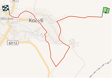
3,6 km | 5,5 km-effort
1h 14min
![](https://static1.geolcdn.com/siteimages/upload/files/16400158638029165_repeat_loop_refresh_sync_direction_icon.png)
Nein
![Tour Zu Fuß Nußlau - [M] Nosislav - Výhon - Photo](https://media.geolcdn.com/t/375/260/f5229b3c-0400-439f-9460-019b796ae514.jpeg&format=jpg&maxdim=2)
![Zu Fuß Zu Fuß](https://static1.geolcdn.com/sitytour/trail-icons/100.png)
[M] Nosislav - Výhon
Zu Fuß
Einfach
Nußlau,
Südosten,
Südmährische Region,
Czech Republic
![](/images/other/stat-length.png)
5,3 km | 7,5 km-effort
1h 41min
![](https://static1.geolcdn.com/siteimages/upload/files/16400158638029165_repeat_loop_refresh_sync_direction_icon.png)
Nein
![Tour Zu Fuß Gaya - NS Kyjov - Bohuslavice - Photo](https://media.geolcdn.com/t/375/260/16565716-f7da-4e94-8dac-0505f2bd9da5.jpeg&format=jpg&maxdim=2)
![Zu Fuß Zu Fuß](https://static1.geolcdn.com/sitytour/trail-icons/100.png)
NS Kyjov - Bohuslavice
Zu Fuß
Einfach
Gaya,
Südosten,
Südmährische Region,
Czech Republic
![](/images/other/stat-length.png)
13,6 km | 17,6 km-effort
3h 59min
![](https://static1.geolcdn.com/siteimages/upload/files/16400158638029165_repeat_loop_refresh_sync_direction_icon.png)
Nein
![Tour Zu Fuß Voitelsbrunn - NS Lednické rybníky - Photo](https://media.geolcdn.com/t/375/260/1c01ab89-d5cd-4c84-82f8-92c11e7665a3.jpeg&format=jpg&maxdim=2)
![Zu Fuß Zu Fuß](https://static1.geolcdn.com/sitytour/trail-icons/100.png)
NS Lednické rybníky
Zu Fuß
Einfach
Voitelsbrunn,
Südosten,
Südmährische Region,
Czech Republic
![](/images/other/stat-length.png)
4,3 km | 4,7 km-effort
1h 4min
![](https://static1.geolcdn.com/siteimages/upload/files/16400158638029165_repeat_loop_refresh_sync_direction_icon.png)
Nein
![Tour Zu Fuß Groß Pawlowitz - NS Zastavení v kraji vína a meruněk - Photo](https://media.geolcdn.com/t/375/260/708e3aa3-f60e-428a-a214-42171592e431.jpeg&format=jpg&maxdim=2)
![Zu Fuß Zu Fuß](https://static1.geolcdn.com/sitytour/trail-icons/100.png)
NS Zastavení v kraji vína a meruněk
Zu Fuß
Einfach
Groß Pawlowitz,
Südosten,
Südmährische Region,
Czech Republic
![](/images/other/stat-length.png)
6,1 km | 7,3 km-effort
1h 40min
![](https://static1.geolcdn.com/siteimages/upload/files/16400158638029165_repeat_loop_refresh_sync_direction_icon.png)
Nein
![Tour Zu Fuß Auspitz - Mandloňová NS - Photo](https://media.geolcdn.com/t/375/260/fe1036b5-094b-4768-a841-ed5954c5125b.jpeg&format=jpg&maxdim=2)
![Zu Fuß Zu Fuß](https://static1.geolcdn.com/sitytour/trail-icons/100.png)
Mandloňová NS
Zu Fuß
Einfach
Auspitz,
Südosten,
Südmährische Region,
Czech Republic
![](/images/other/stat-length.png)
10,1 km | 13,4 km-effort
3h 3min
![](https://static1.geolcdn.com/siteimages/upload/files/16400158638029165_repeat_loop_refresh_sync_direction_icon.png)
Nein
![Tour Zu Fuß Pollau - NS Archeostezka Dolní Věstonice - Pavlov - Photo](https://media.geolcdn.com/t/375/260/5e0199f9-0103-4637-bdf9-f9a02f137294.jpeg&format=jpg&maxdim=2)
![Zu Fuß Zu Fuß](https://static1.geolcdn.com/sitytour/trail-icons/100.png)
NS Archeostezka Dolní Věstonice - Pavlov
Zu Fuß
Einfach
Pollau,
Südosten,
Südmährische Region,
Czech Republic
![](/images/other/stat-length.png)
3,3 km | 3,7 km-effort
51min
![](https://static1.geolcdn.com/siteimages/upload/files/16400158638029165_repeat_loop_refresh_sync_direction_icon.png)
Nein
![Tour Zu Fuß Steinitz - Naučná stezka Motýlí ráj - Photo](https://media.geolcdn.com/t/375/260/d13e0f9b-0034-410d-9fa4-ff218220b19f.jpeg&format=jpg&maxdim=2)
![Zu Fuß Zu Fuß](https://static1.geolcdn.com/sitytour/trail-icons/100.png)
Naučná stezka Motýlí ráj
Zu Fuß
Einfach
Steinitz,
Südosten,
Südmährische Region,
Czech Republic
![](/images/other/stat-length.png)
5,7 km | 7,9 km-effort
1h 47min
![](https://static1.geolcdn.com/siteimages/upload/files/16400158638029165_repeat_loop_refresh_sync_direction_icon.png)
Ja
![Tour Zu Fuß Dubnian - CZ-Jarohněvický rybník - Památník Moravské rovnosti - Photo](https://media.geolcdn.com/t/375/260/e3e43a80-c003-4c5b-9008-f6dc0f7d8e24.jpeg&format=jpg&maxdim=2)
![Zu Fuß Zu Fuß](https://static1.geolcdn.com/sitytour/trail-icons/100.png)
CZ-Jarohněvický rybník - Památník Moravské rovnosti
Zu Fuß
Einfach
Dubnian,
Südosten,
Südmährische Region,
Czech Republic
![](/images/other/stat-length.png)
4 km | 5,1 km-effort
1h 9min
![](https://static1.geolcdn.com/siteimages/upload/files/16400158638029165_repeat_loop_refresh_sync_direction_icon.png)
Nein