![](/images/other/stat-length.png)
![Tour Zu Fuß Unknown - Sv. Martin - Okić - Photo](https://media.geolcdn.com/t/1900/400/7c2964af-cb21-4dd5-adc5-50608cfeb479.jpeg&format=pjpeg&maxdim=2)
Sv. Martin - Okić
SityTrail - itinéraires balisés pédestres
Tous les sentiers balisés d’Europe GUIDE+
![Länge](/images/other/stat-length.png)
Länge
3,5 km
![Maximale Höhe](https://static1.geolcdn.com/siteimages/upload/files/1508320355ic_sort_altitude_max_24dp.png)
Maximale Höhe
411 m
![Positive Höhendifferenz](https://static1.geolcdn.com/siteimages/upload/files/1508320355ic_sort_den_pos_24dp.png)
Positive Höhendifferenz
250 m
![Km-Effort](/images/other/stat-length.png)
Km-Effort
6,1 km
![Min. Höhe](https://static1.geolcdn.com/siteimages/upload/files/1508320355ic_sort_altitude_min_24dp.png)
Min. Höhe
177 m
![Negative Höhendifferenz](https://static1.geolcdn.com/siteimages/upload/files/1508320355ic_sort_den_neg_24dp.png)
Negative Höhendifferenz
22 m
![Boucle](https://static1.geolcdn.com/siteimages/upload/files/16400158638029165_repeat_loop_refresh_sync_direction_icon.png)
Boucle
Nein
Kennzeichnung
Erstellungsdatum :
2025-02-07 10:41:08.761
Letzte Änderung :
2025-02-07 10:41:08.761
![Zu Fuß](https://static1.geolcdn.com/sitytour/trail-icons/100.png)
1h22
Schwierigkeit : Einfach
![Scannen Sie diesen QR-Code, um die Tour in der SityTrail-Anwendung zu öffnen](https://capi.geolives.com/qq0zvz2zws4bq2lad0pu/sitytour/trails/4345315/qr.png?size=200)
Kostenlosegpshiking-Anwendung
Über SityTrail
Tour Zu Fuß von 3,5 km verfügbar auf Unbekannt, Gespanschaft Zagreb. Diese Tour wird von SityTrail - itinéraires balisés pédestres vorgeschlagen.
Beschreibung
Tour erstellt von HPD Kapela, Zagreb.
Sv. Martin (a.p.) - Mihina staza - Podiščak - Klake (a.p.) - Jakopci (Etno kuća) - Pl. dom pod Okićem
Ort
Land:
Croatia
Region :
Unbekannt
Abteilung/Provinz :
Gespanschaft Zagreb
Kommune :
Unknown
Standort:
Unknown
Gehen Sie:(Dec)
Gehen Sie:(UTM)
557194 ; 5066211 (33T) N.
Kommentare
Touren in der Umgebung
![Tour Zu Fuß - Rude - Plešivica - Photo](https://media.geolcdn.com/t/375/260/64d55e2e-dd75-4144-9e92-e25a189ac92c.jpeg&format=jpg&maxdim=2)
![Zu Fuß Zu Fuß](https://static1.geolcdn.com/sitytour/trail-icons/100.png)
Rude - Plešivica
Zu Fuß
Einfach
,
Unbekannt,
Gespanschaft Zagreb,
Croatia
![](/images/other/stat-length.png)
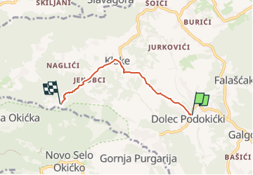
3,8 km | 8,4 km-effort
1h 53min
![](https://static1.geolcdn.com/siteimages/upload/files/16400158638029165_repeat_loop_refresh_sync_direction_icon.png)
Nein
![Tour Zu Fuß - Galgovo - Okić - Photo](https://media.geolcdn.com/t/375/260/02b13133-b05b-42c7-9042-0684cb5ca176.jpeg&format=jpg&maxdim=2)
![Zu Fuß Zu Fuß](https://static1.geolcdn.com/sitytour/trail-icons/100.png)
Galgovo - Okić
Zu Fuß
Einfach
,
Unbekannt,
Gespanschaft Zagreb,
Croatia
![](/images/other/stat-length.png)
4,2 km | 6 km-effort
1h 21min
![](https://static1.geolcdn.com/siteimages/upload/files/16400158638029165_repeat_loop_refresh_sync_direction_icon.png)
Nein
![Tour Zu Fuß - Popovdol - Plešivica - Photo](https://media.geolcdn.com/t/375/260/0eff10e0-d497-4979-a243-eff869dff092.jpeg&format=jpg&maxdim=2)
![Zu Fuß Zu Fuß](https://static1.geolcdn.com/sitytour/trail-icons/100.png)
Popovdol - Plešivica
Zu Fuß
Einfach
,
Unbekannt,
Gespanschaft Zagreb,
Croatia
![](/images/other/stat-length.png)
3,2 km | 7,6 km-effort
1h 43min
![](https://static1.geolcdn.com/siteimages/upload/files/16400158638029165_repeat_loop_refresh_sync_direction_icon.png)
Nein
![Tour Zu Fuß Svetonedeljski Breg - Stepinčev put 5. etapa - Photo](https://media.geolcdn.com/t/375/260/29db60e5-e299-4503-a6f4-cfe86e766c98.jpeg&format=jpg&maxdim=2)
![Zu Fuß Zu Fuß](https://static1.geolcdn.com/sitytour/trail-icons/100.png)
Stepinčev put 5. etapa
Zu Fuß
Einfach
Svetonedeljski Breg,
Unbekannt,
Gespanschaft Zagreb,
Croatia
![](/images/other/stat-length.png)
8 km | 9,1 km-effort
2h 3min
![](https://static1.geolcdn.com/siteimages/upload/files/16400158638029165_repeat_loop_refresh_sync_direction_icon.png)
Nein