![](/images/other/stat-length.png)
![Tour Zu Fuß Lesonice - Lesonická školní naučná stezka - Photo](https://media.geolcdn.com/t/1900/400/b285cb7a-55e5-4a04-996b-db6be9f92a12.jpeg&format=pjpeg&maxdim=2)
Lesonická školní naučná stezka
SityTrail - itinéraires balisés pédestres
Tous les sentiers balisés d’Europe GUIDE+
![Länge](/images/other/stat-length.png)
Länge
3,7 km
![Maximale Höhe](https://static1.geolcdn.com/siteimages/upload/files/1508320355ic_sort_altitude_max_24dp.png)
Maximale Höhe
342 m
![Positive Höhendifferenz](https://static1.geolcdn.com/siteimages/upload/files/1508320355ic_sort_den_pos_24dp.png)
Positive Höhendifferenz
89 m
![Km-Effort](/images/other/stat-length.png)
Km-Effort
4,8 km
![Min. Höhe](https://static1.geolcdn.com/siteimages/upload/files/1508320355ic_sort_altitude_min_24dp.png)
Min. Höhe
271 m
![Negative Höhendifferenz](https://static1.geolcdn.com/siteimages/upload/files/1508320355ic_sort_den_neg_24dp.png)
Negative Höhendifferenz
71 m
![Boucle](https://static1.geolcdn.com/siteimages/upload/files/16400158638029165_repeat_loop_refresh_sync_direction_icon.png)
Boucle
Ja
Kennzeichnung
Erstellungsdatum :
2025-02-07 09:18:20.487
Letzte Änderung :
2025-02-07 09:18:20.487
![Zu Fuß](https://static1.geolcdn.com/sitytour/trail-icons/100.png)
1h05
Schwierigkeit : Einfach
![Scannen Sie diesen QR-Code, um die Tour in der SityTrail-Anwendung zu öffnen](https://capi.geolives.com/qq0zvz2zws4bq2lad0pu/sitytour/trails/4345068/qr.png?size=200)
Kostenlosegpshiking-Anwendung
Über SityTrail
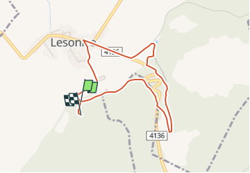
Tour Zu Fuß von 3,7 km verfügbar auf Südosten, Südmährische Region, Lesonice. Diese Tour wird von SityTrail - itinéraires balisés pédestres vorgeschlagen.
Beschreibung
Tour erstellt von cz:KČT.
Ort
Land:
Czech Republic
Region :
Südosten
Abteilung/Provinz :
Südmährische Region
Kommune :
Lesonice
Standort:
Unknown
Gehen Sie:(Dec)
Gehen Sie:(UTM)
595941 ; 5428098 (33U) N.
Kommentare
Touren in der Umgebung
![Tour Zu Fuß Mikulovice - NS moravského včelařství - Photo](https://media.geolcdn.com/t/375/260/aecb43d3-b381-46bc-996f-8597bd3a76e0.jpeg&format=jpg&maxdim=2)
![Zu Fuß Zu Fuß](https://static1.geolcdn.com/sitytour/trail-icons/100.png)
NS moravského včelařství
Zu Fuß
Einfach
Mikulovice,
Südosten,
Südmährische Region,
Czech Republic
![](/images/other/stat-length.png)
4,1 km | 4,9 km-effort
1h 6min
![](https://static1.geolcdn.com/siteimages/upload/files/16400158638029165_repeat_loop_refresh_sync_direction_icon.png)
Ja
![Tour Zu Fuß Mißlitz - Okruh Miroslavské kopce - Photo](https://media.geolcdn.com/t/375/260/3221cc3c-a9f3-4f28-880f-beaad17e940f.jpeg&format=jpg&maxdim=2)
![Zu Fuß Zu Fuß](https://static1.geolcdn.com/sitytour/trail-icons/100.png)
Okruh Miroslavské kopce
Zu Fuß
Einfach
Mißlitz,
Südosten,
Südmährische Region,
Czech Republic
![](/images/other/stat-length.png)
4,4 km | 5,7 km-effort
1h 17min
![](https://static1.geolcdn.com/siteimages/upload/files/16400158638029165_repeat_loop_refresh_sync_direction_icon.png)
Ja
![Tour Zu Fuß Possitz - NS Údolím lásky - Photo](https://media.geolcdn.com/t/375/260/33569034-0db8-4d72-a0e8-ffb991a038f9.jpeg&format=jpg&maxdim=2)
![Zu Fuß Zu Fuß](https://static1.geolcdn.com/sitytour/trail-icons/100.png)
NS Údolím lásky
Zu Fuß
Einfach
Possitz,
Südosten,
Südmährische Region,
Czech Republic
![](/images/other/stat-length.png)
3,8 km | 4,2 km-effort
56min
![](https://static1.geolcdn.com/siteimages/upload/files/16400158638029165_repeat_loop_refresh_sync_direction_icon.png)
Nein
![Tour Zu Fuß Weißstätten - naučná stezka Věstonická nádrž - Photo](https://media.geolcdn.com/t/375/260/3d0b1149-4243-407e-a2fd-50ba23414fb3.jpeg&format=jpg&maxdim=2)
![Zu Fuß Zu Fuß](https://static1.geolcdn.com/sitytour/trail-icons/100.png)
naučná stezka Věstonická nádrž
Zu Fuß
Einfach
Weißstätten,
Südosten,
Südmährische Region,
Czech Republic
![](/images/other/stat-length.png)
13,3 km | 14,5 km-effort
3h 17min
![](https://static1.geolcdn.com/siteimages/upload/files/16400158638029165_repeat_loop_refresh_sync_direction_icon.png)
Nein
![Tour Zu Fuß Mohelno - Naučná stezka národní přírodní rezervace Mohelenská hadcová step - Photo](https://media.geolcdn.com/t/375/260/83a4f499-7909-4101-ba16-31f711dd9df3.jpeg&format=jpg&maxdim=2)
![Zu Fuß Zu Fuß](https://static1.geolcdn.com/sitytour/trail-icons/100.png)
Naučná stezka národní přírodní rezervace Mohelenská hadcová step
Zu Fuß
Einfach
Mohelno,
Südosten,
Region Hochland,
Czech Republic
![](/images/other/stat-length.png)
3,2 km | 4,8 km-effort
1h 5min
![](https://static1.geolcdn.com/siteimages/upload/files/16400158638029165_repeat_loop_refresh_sync_direction_icon.png)
Ja
![Tour Zu Fuß Znaim - [Č] Vranov - Železné schody - Photo](https://media.geolcdn.com/t/375/260/ca9151e2-7333-4e44-883d-767759caa06c.jpeg&format=jpg&maxdim=2)
![Zu Fuß Zu Fuß](https://static1.geolcdn.com/sitytour/trail-icons/100.png)
[Č] Vranov - Železné schody
Zu Fuß
Schwierig
Znaim,
Südosten,
Südmährische Region,
Czech Republic
![](/images/other/stat-length.png)
30 km | 40 km-effort
9h 10min
![](https://static1.geolcdn.com/siteimages/upload/files/16400158638029165_repeat_loop_refresh_sync_direction_icon.png)
Nein
![Tour Zu Fuß Hrotovice - Naučná stezka Hrotovicko - Photo](https://media.geolcdn.com/t/375/260/e18d395d-d747-4c12-95c6-35df7e68fcca.jpeg&format=jpg&maxdim=2)
![Zu Fuß Zu Fuß](https://static1.geolcdn.com/sitytour/trail-icons/100.png)
Naučná stezka Hrotovicko
Zu Fuß
Einfach
Hrotovice,
Südosten,
Region Hochland,
Czech Republic
![](/images/other/stat-length.png)
4,8 km | 5,9 km-effort
1h 20min
![](https://static1.geolcdn.com/siteimages/upload/files/16400158638029165_repeat_loop_refresh_sync_direction_icon.png)
Ja
![Tour Zu Fuß Mährisch Kromau - Naučná stezka Krumlovsko-rokytenské slepence - Photo](https://media.geolcdn.com/t/375/260/03d92479-7962-46d4-a59f-f656a2bfdcc9.jpeg&format=jpg&maxdim=2)
![Zu Fuß Zu Fuß](https://static1.geolcdn.com/sitytour/trail-icons/100.png)
Naučná stezka Krumlovsko-rokytenské slepence
Zu Fuß
Einfach
Mährisch Kromau,
Südosten,
Südmährische Region,
Czech Republic
![](/images/other/stat-length.png)
10,4 km | 12,4 km-effort
2h 49min
![](https://static1.geolcdn.com/siteimages/upload/files/16400158638029165_repeat_loop_refresh_sync_direction_icon.png)
Nein
![Tour Zu Fuß Mährisch Kromau - Naučná stezka Krumlovsko-rokytenské slepence - Photo](https://media.geolcdn.com/t/375/260/3389b225-83d9-4632-923f-a937729cffa7.jpeg&format=jpg&maxdim=2)
![Zu Fuß Zu Fuß](https://static1.geolcdn.com/sitytour/trail-icons/100.png)
Naučná stezka Krumlovsko-rokytenské slepence
Zu Fuß
Einfach
Mährisch Kromau,
Südosten,
Südmährische Region,
Czech Republic
![](/images/other/stat-length.png)
4,2 km | 5 km-effort
1h 8min
![](https://static1.geolcdn.com/siteimages/upload/files/16400158638029165_repeat_loop_refresh_sync_direction_icon.png)
Nein