


10,1 km | 11 km-effort
![Tour Zu Fuß Choruschitz - [M] Mělnická Vrutice - Zahájí - Photo](https://media.geolcdn.com/t/1900/400/5bbe73f2-35ef-41ee-977d-f53953a5ded4.jpeg&format=pjpeg&maxdim=2)

Tous les sentiers balisés d’Europe GUIDE+


Kostenlosegpshiking-Anwendung
 SityTrail
IGN / Geografische Institute
SityTrail World
Die Welt öffnet sich für Sie
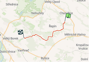
Tour Zu Fuß von 12,3 km verfügbar auf Mittelböhmen, Unbekannt, Choruschitz. Diese Tour wird von SityTrail - itinéraires balisés pédestres vorgeschlagen.
Tour erstellt von cz:KČT.
![Tour Zu Fuß Choruschitz - [M] Mělnická Vrutice - Zahájí - Photo 1](https://media.geolcdn.com/t/2048/auto/0bc2f3d3-c5db-42de-afcc-77cbd5049f3b.jpeg&format=jpg&maxdim=0 "Tour Zu Fuß Choruschitz - [M] Mělnická Vrutice - Zahájí - Photo 1")
![Tour Zu Fuß Choruschitz - [M] Mělnická Vrutice - Zahájí - Photo 2](https://media.geolcdn.com/t/2048/auto/f5b2ad61-11bb-4ebc-9eb3-acff48d48ded.jpeg&format=jpg&maxdim=0 "Tour Zu Fuß Choruschitz - [M] Mělnická Vrutice - Zahájí - Photo 2")
![Tour Zu Fuß Choruschitz - [M] Mělnická Vrutice - Zahájí - Photo 3](https://media.geolcdn.com/t/2048/auto/6eb2bd98-6cdf-472b-8258-aafe9b2e4439.jpeg&format=jpg&maxdim=0 "Tour Zu Fuß Choruschitz - [M] Mělnická Vrutice - Zahájí - Photo 3")
![Tour Zu Fuß Choruschitz - [M] Mělnická Vrutice - Zahájí - Photo 4](https://media.geolcdn.com/t/2048/auto/3c0a488e-54b3-4807-87a6-4dcab0028365.jpeg&format=jpg&maxdim=0 "Tour Zu Fuß Choruschitz - [M] Mělnická Vrutice - Zahájí - Photo 4")
![Tour Zu Fuß Choruschitz - [M] Mělnická Vrutice - Zahájí - Photo 5](https://media.geolcdn.com/t/2048/auto/09b3a2e8-b242-4dfe-9a03-d26af18d1c36.jpeg&format=jpg&maxdim=0 "Tour Zu Fuß Choruschitz - [M] Mělnická Vrutice - Zahájí - Photo 5")
![Tour Zu Fuß Choruschitz - [M] Mělnická Vrutice - Zahájí - Photo 6](https://media.geolcdn.com/t/2048/auto/60613977-8335-4e18-b727-9822839438cd.jpeg&format=jpg&maxdim=0 "Tour Zu Fuß Choruschitz - [M] Mělnická Vrutice - Zahájí - Photo 6")
![Tour Zu Fuß Choruschitz - [M] Mělnická Vrutice - Zahájí - Photo 7](https://media.geolcdn.com/t/2048/auto/ab031d48-35e4-433a-8ed3-e0950b47f3c0.jpeg&format=jpg&maxdim=0 "Tour Zu Fuß Choruschitz - [M] Mělnická Vrutice - Zahájí - Photo 7")
![Tour Zu Fuß Choruschitz - [M] Mělnická Vrutice - Zahájí - Photo 8](https://media.geolcdn.com/t/2048/auto/bb91b894-8422-4460-8ec1-1ebf809bc8d6.jpeg&format=jpg&maxdim=0 "Tour Zu Fuß Choruschitz - [M] Mělnická Vrutice - Zahájí - Photo 8")
![Tour Zu Fuß Choruschitz - [M] Mělnická Vrutice - Zahájí - Photo 9](https://media.geolcdn.com/t/2048/auto/5bbe73f2-35ef-41ee-977d-f53953a5ded4.jpeg&format=jpg&maxdim=0 "Tour Zu Fuß Choruschitz - [M] Mělnická Vrutice - Zahájí - Photo 9")
![Tour Zu Fuß Choruschitz - [M] Mělnická Vrutice - Zahájí - Photo 10](https://media.geolcdn.com/t/2048/auto/a5b745f7-c07f-4f45-a2b9-1b5c8586b924.jpeg&format=jpg&maxdim=0 "Tour Zu Fuß Choruschitz - [M] Mělnická Vrutice - Zahájí - Photo 10")
![Tour Zu Fuß Kojetitz - [Z] Kojetice - Kostelec nad Labem - Photo](https://media.geolcdn.com/t/375/260/b48711fe-946a-4219-93f6-8a21a39e13c4.jpeg&format=jpg&maxdim=2)
Zu Fuß
Zu Fuß
![Tour Zu Fuß Dauba - [Z] Dubá - místní okruh - Photo](https://media.geolcdn.com/t/375/260/34bbea99-b172-428f-985b-ab1f4428ddc7.jpeg&format=jpg&maxdim=2)
Zu Fuß
Zu Fuß
Zu Fuß
Zu Fuß
Zu Fuß
Zu Fuß
Zu Fuß