![](/images/other/stat-length.png)
![Tour Zu Fuß Kunstadt - [Ž] Svitávka - Rudka - Photo](https://media.geolcdn.com/t/1900/400/94d66308-b810-471c-9787-b29d9f662f14.jpeg&format=pjpeg&maxdim=2)
[Ž] Svitávka - Rudka
SityTrail - itinéraires balisés pédestres
Tous les sentiers balisés d’Europe GUIDE+
![Länge](/images/other/stat-length.png)
Länge
10,6 km
![Maximale Höhe](https://static1.geolcdn.com/siteimages/upload/files/1508320355ic_sort_altitude_max_24dp.png)
Maximale Höhe
550 m
![Positive Höhendifferenz](https://static1.geolcdn.com/siteimages/upload/files/1508320355ic_sort_den_pos_24dp.png)
Positive Höhendifferenz
115 m
![Km-Effort](/images/other/stat-length.png)
Km-Effort
12,6 km
![Min. Höhe](https://static1.geolcdn.com/siteimages/upload/files/1508320355ic_sort_altitude_min_24dp.png)
Min. Höhe
311 m
![Negative Höhendifferenz](https://static1.geolcdn.com/siteimages/upload/files/1508320355ic_sort_den_neg_24dp.png)
Negative Höhendifferenz
263 m
![Boucle](https://static1.geolcdn.com/siteimages/upload/files/16400158638029165_repeat_loop_refresh_sync_direction_icon.png)
Boucle
Nein
Kennzeichnung
Erstellungsdatum :
2025-02-07 05:56:35.516
Letzte Änderung :
2025-02-07 05:56:35.516
![Zu Fuß](https://static1.geolcdn.com/sitytour/trail-icons/100.png)
2h52
Schwierigkeit : Einfach
![Scannen Sie diesen QR-Code, um die Tour in der SityTrail-Anwendung zu öffnen](https://capi.geolives.com/qq0zvz2zws4bq2lad0pu/sitytour/trails/4344726/qr.png?size=200)
Kostenlosegpshiking-Anwendung
Über SityTrail
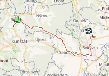
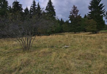
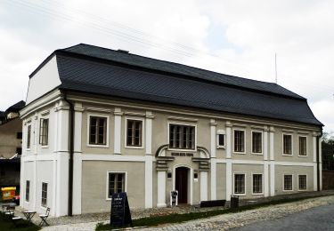
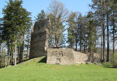
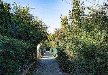
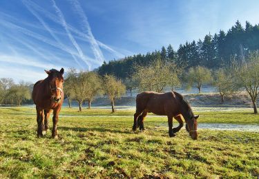
Tour Zu Fuß von 10,6 km verfügbar auf Südosten, Südmährische Region, Kunstadt. Diese Tour wird von SityTrail - itinéraires balisés pédestres vorgeschlagen.
Beschreibung
Tour erstellt von cz:KČT.
Ort
Land:
Czech Republic
Region :
Südosten
Abteilung/Provinz :
Südmährische Region
Kommune :
Kunstadt
Standort:
Unknown
Gehen Sie:(Dec)
Gehen Sie:(UTM)
609361 ; 5486064 (33U) N.
Kommentare
Touren in der Umgebung
![Tour Zu Fuß Boskowitz - Oborský okruh - Photo](https://media.geolcdn.com/t/375/260/84b9fd7e-e648-46b8-b5cd-960bfef2d315.jpeg&format=jpg&maxdim=2)
![Zu Fuß Zu Fuß](https://static1.geolcdn.com/sitytour/trail-icons/100.png)
Oborský okruh
Zu Fuß
Einfach
Boskowitz,
Südosten,
Südmährische Region,
Czech Republic
![](/images/other/stat-length.png)
3,8 km | 5,1 km-effort
1h 8min
![](https://static1.geolcdn.com/siteimages/upload/files/16400158638029165_repeat_loop_refresh_sync_direction_icon.png)
Ja
![Tour Zu Fuß Lettowitz - Naučná stezka Hanýsek - Photo](https://media.geolcdn.com/t/375/260/37b52384-35e3-4d83-9a67-a058a018f8b7.jpeg&format=jpg&maxdim=2)
![Zu Fuß Zu Fuß](https://static1.geolcdn.com/sitytour/trail-icons/100.png)
Naučná stezka Hanýsek
Zu Fuß
Einfach
Lettowitz,
Südosten,
Südmährische Region,
Czech Republic
![](/images/other/stat-length.png)
10 km | 13,7 km-effort
3h 6min
![](https://static1.geolcdn.com/siteimages/upload/files/16400158638029165_repeat_loop_refresh_sync_direction_icon.png)
Nein
![Tour Zu Fuß Nedvědice - Po naučných stezkách na hrad Pernštejn I. etapa - Photo](https://media.geolcdn.com/t/375/260/f0f9e1db-cb23-468e-bac3-af798b271997.jpeg&format=jpg&maxdim=2)
![Zu Fuß Zu Fuß](https://static1.geolcdn.com/sitytour/trail-icons/100.png)
Po naučných stezkách na hrad Pernštejn I. etapa
Zu Fuß
Einfach
Nedvědice,
Südosten,
Südmährische Region,
Czech Republic
![](/images/other/stat-length.png)
3,3 km | 5 km-effort
1h 8min
![](https://static1.geolcdn.com/siteimages/upload/files/16400158638029165_repeat_loop_refresh_sync_direction_icon.png)
Nein
![Tour Zu Fuß Gewitsch - [Z] Jevíčko - Moravská Třebová - Photo](https://media.geolcdn.com/t/375/260/4a2c21ce-2e85-4599-a679-af93a46a0a15.jpeg&format=jpg&maxdim=2)
![Zu Fuß Zu Fuß](https://static1.geolcdn.com/sitytour/trail-icons/100.png)
[Z] Jevíčko - Moravská Třebová
Zu Fuß
Medium
Gewitsch,
Nordosten,
Pardubitzer Region,
Czech Republic
![](/images/other/stat-length.png)
17,6 km | 25 km-effort
5h 36min
![](https://static1.geolcdn.com/siteimages/upload/files/16400158638029165_repeat_loop_refresh_sync_direction_icon.png)
Nein
![Tour Zu Fuß Lomnitz - naučná stezka Járy Cimrmana - Photo](https://media.geolcdn.com/t/375/260/10d7421d-cfd1-4327-8e81-fb06f3955da3.jpeg&format=jpg&maxdim=2)
![Zu Fuß Zu Fuß](https://static1.geolcdn.com/sitytour/trail-icons/100.png)
naučná stezka Járy Cimrmana
Zu Fuß
Einfach
Lomnitz,
Südosten,
Südmährische Region,
Czech Republic
![](/images/other/stat-length.png)
4,9 km | 7,7 km-effort
1h 45min
![](https://static1.geolcdn.com/siteimages/upload/files/16400158638029165_repeat_loop_refresh_sync_direction_icon.png)
Nein
![Tour Zu Fuß Předklášteří - Naučná stezka Květnice - Photo](https://media.geolcdn.com/t/375/260/2c18e53a-ea8e-4eb9-9d60-e34adc5101e9.jpeg&format=jpg&maxdim=2)
![Zu Fuß Zu Fuß](https://static1.geolcdn.com/sitytour/trail-icons/100.png)
Naučná stezka Květnice
Zu Fuß
Einfach
Předklášteří,
Südosten,
Südmährische Region,
Czech Republic
![](/images/other/stat-length.png)
6,2 km | 9,2 km-effort
2h 5min
![](https://static1.geolcdn.com/siteimages/upload/files/16400158638029165_repeat_loop_refresh_sync_direction_icon.png)
Ja
![Tour Zu Fuß Koroužné - Svratecká vodohospodářská naučná stezka - Photo](https://media.geolcdn.com/t/375/260/26f5476c-43fa-4ca2-9ff8-3ede3473eb76.jpeg&format=jpg&maxdim=2)
![Zu Fuß Zu Fuß](https://static1.geolcdn.com/sitytour/trail-icons/100.png)
Svratecká vodohospodářská naučná stezka
Zu Fuß
Medium
Koroužné,
Südosten,
Region Hochland,
Czech Republic
![](/images/other/stat-length.png)
16,4 km | 21 km-effort
4h 47min
![](https://static1.geolcdn.com/siteimages/upload/files/16400158638029165_repeat_loop_refresh_sync_direction_icon.png)
Nein
![Tour Zu Fuß Boskowitz - Doubravský okruh - Photo](https://media.geolcdn.com/t/375/260/7b18f6af-d35b-437d-b3b3-aa6accde167d.jpeg&format=jpg&maxdim=2)
![Zu Fuß Zu Fuß](https://static1.geolcdn.com/sitytour/trail-icons/100.png)
Doubravský okruh
Zu Fuß
Einfach
Boskowitz,
Südosten,
Südmährische Region,
Czech Republic
![](/images/other/stat-length.png)
7 km | 8,7 km-effort
1h 58min
![](https://static1.geolcdn.com/siteimages/upload/files/16400158638029165_repeat_loop_refresh_sync_direction_icon.png)
Ja
![Tour Zu Fuß Boskowitz - Hradní okruh - Photo](https://media.geolcdn.com/t/375/260/9224c81d-4554-42ad-a8b5-60d445d4d7cd.jpeg&format=jpg&maxdim=2)
![Zu Fuß Zu Fuß](https://static1.geolcdn.com/sitytour/trail-icons/100.png)
Hradní okruh
Zu Fuß
Einfach
Boskowitz,
Südosten,
Südmährische Region,
Czech Republic
![](/images/other/stat-length.png)
6,4 km | 9,1 km-effort
2h 4min
![](https://static1.geolcdn.com/siteimages/upload/files/16400158638029165_repeat_loop_refresh_sync_direction_icon.png)
Ja