


6 km | 7,4 km-effort
![Tour Zu Fuß Kunzendorf - [Ž] Mladějov - Nad Vískou - Photo](https://media.geolcdn.com/t/1900/400/7dbb655f-18d2-4009-8e37-3f4533b92481.jpeg&format=pjpeg&maxdim=2)

Tous les sentiers balisés d’Europe GUIDE+


Kostenlosegpshiking-Anwendung
 SityTrail
IGN / Geografische Institute
SityTrail World
Die Welt öffnet sich für Sie
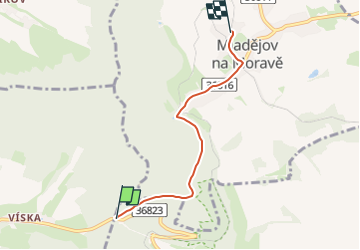
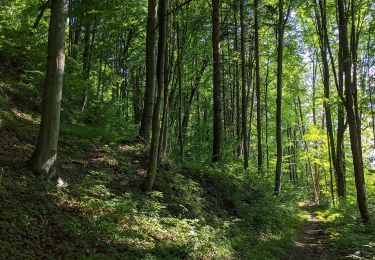
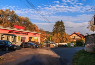
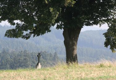
Tour Zu Fuß von 3,8 km verfügbar auf Nordosten, Pardubitzer Region, Kunzendorf. Diese Tour wird von SityTrail - itinéraires balisés pédestres vorgeschlagen.
Tour erstellt von cz:KČT.
![Tour Zu Fuß Kunzendorf - [Ž] Mladějov - Nad Vískou - Photo 1](https://media.geolcdn.com/t/2048/auto/cbd30df9-ec3c-4b2f-988a-cef0918b05a1.jpeg&format=jpg&maxdim=0 "Tour Zu Fuß Kunzendorf - [Ž] Mladějov - Nad Vískou - Photo 1")
![Tour Zu Fuß Kunzendorf - [Ž] Mladějov - Nad Vískou - Photo 2](https://media.geolcdn.com/t/2048/auto/47a9bc89-e28f-4347-885e-fab403ae84db.jpeg&format=jpg&maxdim=0 "Tour Zu Fuß Kunzendorf - [Ž] Mladějov - Nad Vískou - Photo 2")
![Tour Zu Fuß Kunzendorf - [Ž] Mladějov - Nad Vískou - Photo 3](https://media.geolcdn.com/t/2048/auto/21a25318-cbc6-4665-9062-3afaf09a924e.jpeg&format=jpg&maxdim=0 "Tour Zu Fuß Kunzendorf - [Ž] Mladějov - Nad Vískou - Photo 3")
![Tour Zu Fuß Kunzendorf - [Ž] Mladějov - Nad Vískou - Photo 4](https://media.geolcdn.com/t/2048/auto/7e3cc100-2566-480b-bf6f-8a0dc979223d.jpeg&format=jpg&maxdim=0 "Tour Zu Fuß Kunzendorf - [Ž] Mladějov - Nad Vískou - Photo 4")
![Tour Zu Fuß Kunzendorf - [Ž] Mladějov - Nad Vískou - Photo 5](https://media.geolcdn.com/t/2048/auto/3bb6faa6-ba3b-4fb3-a197-46e48fcf9c09.jpeg&format=jpg&maxdim=0 "Tour Zu Fuß Kunzendorf - [Ž] Mladějov - Nad Vískou - Photo 5")
![Tour Zu Fuß Kunzendorf - [Ž] Mladějov - Nad Vískou - Photo 6](https://media.geolcdn.com/t/2048/auto/9d944e2d-a1e2-4810-8608-87ea904c8de6.jpeg&format=jpg&maxdim=0 "Tour Zu Fuß Kunzendorf - [Ž] Mladějov - Nad Vískou - Photo 6")
![Tour Zu Fuß Kunzendorf - [Ž] Mladějov - Nad Vískou - Photo 7](https://media.geolcdn.com/t/2048/auto/da237916-c002-4434-b6b6-048506c9a26f.jpeg&format=jpg&maxdim=0 "Tour Zu Fuß Kunzendorf - [Ž] Mladějov - Nad Vískou - Photo 7")
![Tour Zu Fuß Kunzendorf - [Ž] Mladějov - Nad Vískou - Photo 8](https://media.geolcdn.com/t/2048/auto/70fa5969-3663-4125-ba7a-3049a55993ab.jpeg&format=jpg&maxdim=0 "Tour Zu Fuß Kunzendorf - [Ž] Mladějov - Nad Vískou - Photo 8")
![Tour Zu Fuß Kunzendorf - [Ž] Mladějov - Nad Vískou - Photo 9](https://media.geolcdn.com/t/2048/auto/7dbb655f-18d2-4009-8e37-3f4533b92481.jpeg&format=jpg&maxdim=0 "Tour Zu Fuß Kunzendorf - [Ž] Mladějov - Nad Vískou - Photo 9")
![Tour Zu Fuß Kunzendorf - [Ž] Mladějov - Nad Vískou - Photo 10](https://media.geolcdn.com/t/2048/auto/84c1587d-81a0-4c01-ab87-935fc6638279.jpeg&format=jpg&maxdim=0 "Tour Zu Fuß Kunzendorf - [Ž] Mladějov - Nad Vískou - Photo 10")
Zu Fuß
Zu Fuß
![Tour Zu Fuß Tattenitz - [M] Cukrová bouda - Tatenice - Photo](https://media.geolcdn.com/t/375/260/d7936ed9-d5a8-4f9e-8f62-c7c3895a88ed.jpeg&format=jpg&maxdim=2)
Zu Fuß
Zu Fuß
Zu Fuß
![Tour Zu Fuß Kukele - [Č] Vozíčkářský okruh nad Rosničkou - Photo](https://media.geolcdn.com/t/375/260/a09e8f9b-db43-4592-b8eb-0648f5280109.jpeg&format=jpg&maxdim=2)
Zu Fuß
Zu Fuß
![Tour Zu Fuß Böhmisch Trübau - [Ž] Pod Kozlovcem - Pod Skuhrovem - Photo](https://media.geolcdn.com/t/375/260/e10c881f-a244-44ac-b766-3afd8215abfb.jpeg&format=jpg&maxdim=2)
Zu Fuß
Zu Fuß