


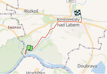

3,5 km | 3,9 km-effort
![Tour Zu Fuß Kostomlaty nad Labem - [Ž] Kostomlaty nad Labem - ústí Vlkavy - Photo](https://media.geolcdn.com/t/1900/400/8043a1fa-bd2d-496a-9ca7-505e6aaabd52.jpeg&format=pjpeg&maxdim=2)

Tous les sentiers balisés d’Europe GUIDE+


Kostenlosegpshiking-Anwendung
 SityTrail
IGN / Geografische Institute
SityTrail World
Die Welt öffnet sich für Sie
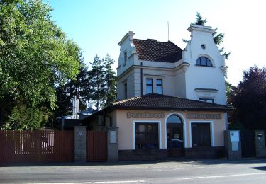
Tour Zu Fuß von 3,3 km verfügbar auf Mittelböhmen, Unbekannt, Kostomlaty nad Labem. Diese Tour wird von SityTrail - itinéraires balisés pédestres vorgeschlagen.
Tour erstellt von cz:KČT.
![Tour Zu Fuß Kostomlaty nad Labem - [Ž] Kostomlaty nad Labem - ústí Vlkavy - Photo 1](https://media.geolcdn.com/t/2048/auto/ada1d94e-59a0-4bd6-b268-f3a14d47e1cf.jpeg&format=jpg&maxdim=0 "Tour Zu Fuß Kostomlaty nad Labem - [Ž] Kostomlaty nad Labem - ústí Vlkavy - Photo 1")
![Tour Zu Fuß Kostomlaty nad Labem - [Ž] Kostomlaty nad Labem - ústí Vlkavy - Photo 2](https://media.geolcdn.com/t/2048/auto/25dbab06-0062-45a5-a750-947f935ba022.jpeg&format=jpg&maxdim=0 "Tour Zu Fuß Kostomlaty nad Labem - [Ž] Kostomlaty nad Labem - ústí Vlkavy - Photo 2")
![Tour Zu Fuß Kostomlaty nad Labem - [Ž] Kostomlaty nad Labem - ústí Vlkavy - Photo 3](https://media.geolcdn.com/t/2048/auto/b17cc20d-a8d8-4abe-94ce-0bbeef3910e3.jpeg&format=jpg&maxdim=0 "Tour Zu Fuß Kostomlaty nad Labem - [Ž] Kostomlaty nad Labem - ústí Vlkavy - Photo 3")
![Tour Zu Fuß Kostomlaty nad Labem - [Ž] Kostomlaty nad Labem - ústí Vlkavy - Photo 4](https://media.geolcdn.com/t/2048/auto/6a09b7ee-266f-481d-a87c-2b36f6b0840d.jpeg&format=jpg&maxdim=0 "Tour Zu Fuß Kostomlaty nad Labem - [Ž] Kostomlaty nad Labem - ústí Vlkavy - Photo 4")
![Tour Zu Fuß Kostomlaty nad Labem - [Ž] Kostomlaty nad Labem - ústí Vlkavy - Photo 5](https://media.geolcdn.com/t/2048/auto/ba92ec45-74ea-4b71-abd5-0970462c439f.jpeg&format=jpg&maxdim=0 "Tour Zu Fuß Kostomlaty nad Labem - [Ž] Kostomlaty nad Labem - ústí Vlkavy - Photo 5")
![Tour Zu Fuß Kostomlaty nad Labem - [Ž] Kostomlaty nad Labem - ústí Vlkavy - Photo 6](https://media.geolcdn.com/t/2048/auto/ee356d1a-ce4e-4125-9591-95169bfb0a57.jpeg&format=jpg&maxdim=0 "Tour Zu Fuß Kostomlaty nad Labem - [Ž] Kostomlaty nad Labem - ústí Vlkavy - Photo 6")
![Tour Zu Fuß Kostomlaty nad Labem - [Ž] Kostomlaty nad Labem - ústí Vlkavy - Photo 7](https://media.geolcdn.com/t/2048/auto/e7a9de0d-7aee-4393-9cd2-7306ed34df10.jpeg&format=jpg&maxdim=0 "Tour Zu Fuß Kostomlaty nad Labem - [Ž] Kostomlaty nad Labem - ústí Vlkavy - Photo 7")
![Tour Zu Fuß Kostomlaty nad Labem - [Ž] Kostomlaty nad Labem - ústí Vlkavy - Photo 8](https://media.geolcdn.com/t/2048/auto/1f419ffb-4243-4526-a853-927b2ff133f1.jpeg&format=jpg&maxdim=0 "Tour Zu Fuß Kostomlaty nad Labem - [Ž] Kostomlaty nad Labem - ústí Vlkavy - Photo 8")
![Tour Zu Fuß Kostomlaty nad Labem - [Ž] Kostomlaty nad Labem - ústí Vlkavy - Photo 9](https://media.geolcdn.com/t/2048/auto/1c4361e7-8c88-44ce-9a29-6f802f1f3c16.jpeg&format=jpg&maxdim=0 "Tour Zu Fuß Kostomlaty nad Labem - [Ž] Kostomlaty nad Labem - ústí Vlkavy - Photo 9")
![Tour Zu Fuß Kostomlaty nad Labem - [Ž] Kostomlaty nad Labem - ústí Vlkavy - Photo 10](https://media.geolcdn.com/t/2048/auto/8043a1fa-bd2d-496a-9ca7-505e6aaabd52.jpeg&format=jpg&maxdim=0 "Tour Zu Fuß Kostomlaty nad Labem - [Ž] Kostomlaty nad Labem - ústí Vlkavy - Photo 10")
Zu Fuß
Zu Fuß
Zu Fuß
![Tour Zu Fuß Svojšice - [M] Bošice - Vrbčany - Photo](https://media.geolcdn.com/t/375/260/49c6768a-d916-4a89-a92c-23d6bf73eede.jpeg&format=jpg&maxdim=2)
Zu Fuß
Zu Fuß
Zu Fuß
Zu Fuß
Zu Fuß
Zu Fuß