


5,3 km | 6,6 km-effort
![Tour Zu Fuß Gießhübel - [M] Olešnice v Orl. Horách - Bedřichovka - Photo](https://media.geolcdn.com/t/1900/400/8d917cb9-8aee-4c96-9005-bee7a60b1f56.jpeg&format=pjpeg&maxdim=2)

Tous les sentiers balisés d’Europe GUIDE+


Kostenlosegpshiking-Anwendung
 SityTrail
IGN / Geografische Institute
SityTrail World
Die Welt öffnet sich für Sie
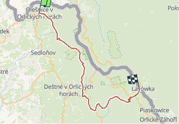
Tour Zu Fuß von 20 km verfügbar auf Nordosten, Königgrätzer Region, Gießhübel. Diese Tour wird von SityTrail - itinéraires balisés pédestres vorgeschlagen.
Tour erstellt von cz:KČT.
[M] Olešnice v Orl. Horách - Bedřichovka
![Tour Zu Fuß Gießhübel - [M] Olešnice v Orl. Horách - Bedřichovka - Photo 1](https://media.geolcdn.com/t/2048/auto/336ed46a-18f6-4b76-87b5-4a114ff66c87.jpeg&format=jpg&maxdim=0 "Tour Zu Fuß Gießhübel - [M] Olešnice v Orl. Horách - Bedřichovka - Photo 1")
![Tour Zu Fuß Gießhübel - [M] Olešnice v Orl. Horách - Bedřichovka - Photo 2](https://media.geolcdn.com/t/2048/auto/11970090-74bd-4ec4-a1a3-05b4e56887af.jpeg&format=jpg&maxdim=0 "Tour Zu Fuß Gießhübel - [M] Olešnice v Orl. Horách - Bedřichovka - Photo 2")
![Tour Zu Fuß Gießhübel - [M] Olešnice v Orl. Horách - Bedřichovka - Photo 3](https://media.geolcdn.com/t/2048/auto/89306a1f-fadb-4ba4-a813-6001f2609e31.jpeg&format=jpg&maxdim=0 "Tour Zu Fuß Gießhübel - [M] Olešnice v Orl. Horách - Bedřichovka - Photo 3")
![Tour Zu Fuß Gießhübel - [M] Olešnice v Orl. Horách - Bedřichovka - Photo 4](https://media.geolcdn.com/t/2048/auto/41d7dceb-2dd9-47b4-b7cc-50e5c0145606.jpeg&format=jpg&maxdim=0 "Tour Zu Fuß Gießhübel - [M] Olešnice v Orl. Horách - Bedřichovka - Photo 4")
![Tour Zu Fuß Gießhübel - [M] Olešnice v Orl. Horách - Bedřichovka - Photo 5](https://media.geolcdn.com/t/2048/auto/ed963acb-6a3a-4ebc-85ee-c692007bc170.jpeg&format=jpg&maxdim=0 "Tour Zu Fuß Gießhübel - [M] Olešnice v Orl. Horách - Bedřichovka - Photo 5")
![Tour Zu Fuß Gießhübel - [M] Olešnice v Orl. Horách - Bedřichovka - Photo 6](https://media.geolcdn.com/t/2048/auto/d404b3b1-ecdf-4766-bb47-246fb9d6611d.jpeg&format=jpg&maxdim=0 "Tour Zu Fuß Gießhübel - [M] Olešnice v Orl. Horách - Bedřichovka - Photo 6")
![Tour Zu Fuß Gießhübel - [M] Olešnice v Orl. Horách - Bedřichovka - Photo 7](https://media.geolcdn.com/t/2048/auto/cea81ce1-1d9f-4dcd-8099-ca0c8432a8dd.jpeg&format=jpg&maxdim=0 "Tour Zu Fuß Gießhübel - [M] Olešnice v Orl. Horách - Bedřichovka - Photo 7")
![Tour Zu Fuß Gießhübel - [M] Olešnice v Orl. Horách - Bedřichovka - Photo 8](https://media.geolcdn.com/t/2048/auto/e21278b7-8739-4900-81ae-a75f99ccb078.jpeg&format=jpg&maxdim=0 "Tour Zu Fuß Gießhübel - [M] Olešnice v Orl. Horách - Bedřichovka - Photo 8")
![Tour Zu Fuß Gießhübel - [M] Olešnice v Orl. Horách - Bedřichovka - Photo 9](https://media.geolcdn.com/t/2048/auto/1a605e19-c121-4ec5-9dd5-6622c81795cb.jpeg&format=jpg&maxdim=0 "Tour Zu Fuß Gießhübel - [M] Olešnice v Orl. Horách - Bedřichovka - Photo 9")
![Tour Zu Fuß Gießhübel - [M] Olešnice v Orl. Horách - Bedřichovka - Photo 10](https://media.geolcdn.com/t/2048/auto/8d917cb9-8aee-4c96-9005-bee7a60b1f56.jpeg&format=jpg&maxdim=0 "Tour Zu Fuß Gießhübel - [M] Olešnice v Orl. Horách - Bedřichovka - Photo 10")
![Tour Zu Fuß Gießhübel - [Ž] Číhalka - Olešnice v Orl. h. (nám.) - Olešnice v Orl. h. (CZ/PL) - Photo](https://media.geolcdn.com/t/375/260/b48ab68f-912d-4bbf-b2f5-172a710dcd1a.jpeg&format=jpg&maxdim=2)
Zu Fuß
![Tour Zu Fuß Gießhübel - [M] Olešnice v Orl. h. - Taszów - Photo](https://media.geolcdn.com/t/375/260/336ed46a-18f6-4b76-87b5-4a114ff66c87.jpeg&format=jpg&maxdim=2)
Zu Fuß
![Tour Zu Fuß Sattel - [Z] Deštné (Národní dům) - Polomské sedlo - Photo](https://media.geolcdn.com/t/375/260/37ae444d-3293-4f88-9dba-0621b4f076e3.jpeg&format=jpg&maxdim=2)
Zu Fuß