![](/images/other/stat-length.png)
![Tour Zu Fuß Römerstadt - Vychodilova stezka - Photo](https://media.geolcdn.com/t/1900/400/2586dd00-5bcd-4c98-83fc-744efc67860c.jpeg&format=pjpeg&maxdim=2)
Vychodilova stezka
SityTrail - itinéraires balisés pédestres
Tous les sentiers balisés d’Europe GUIDE+
![Länge](/images/other/stat-length.png)
Länge
12,6 km
![Maximale Höhe](https://static1.geolcdn.com/siteimages/upload/files/1508320355ic_sort_altitude_max_24dp.png)
Maximale Höhe
664 m
![Positive Höhendifferenz](https://static1.geolcdn.com/siteimages/upload/files/1508320355ic_sort_den_pos_24dp.png)
Positive Höhendifferenz
290 m
![Km-Effort](/images/other/stat-length.png)
Km-Effort
16,5 km
![Min. Höhe](https://static1.geolcdn.com/siteimages/upload/files/1508320355ic_sort_altitude_min_24dp.png)
Min. Höhe
459 m
![Negative Höhendifferenz](https://static1.geolcdn.com/siteimages/upload/files/1508320355ic_sort_den_neg_24dp.png)
Negative Höhendifferenz
287 m
![Boucle](https://static1.geolcdn.com/siteimages/upload/files/16400158638029165_repeat_loop_refresh_sync_direction_icon.png)
Boucle
Ja
Kennzeichnung
Erstellungsdatum :
2025-02-07 02:56:20.972
Letzte Änderung :
2025-02-07 02:56:20.972
![Zu Fuß](https://static1.geolcdn.com/sitytour/trail-icons/100.png)
3h44
Schwierigkeit : Einfach
![Scannen Sie diesen QR-Code, um die Tour in der SityTrail-Anwendung zu öffnen](https://capi.geolives.com/qq0zvz2zws4bq2lad0pu/sitytour/trails/4344487/qr.png?size=200)
Kostenlosegpshiking-Anwendung
Über SityTrail
Tour Zu Fuß von 12,6 km verfügbar auf Mährisch-Schlesien, Mährisch-Schlesische Region, Römerstadt. Diese Tour wird von SityTrail - itinéraires balisés pédestres vorgeschlagen.
Beschreibung
Tour erstellt von cz:KČT.
Ort
Land:
Czech Republic
Region :
Mährisch-Schlesien
Abteilung/Provinz :
Mährisch-Schlesische Region
Kommune :
Römerstadt
Standort:
Unknown
Gehen Sie:(Dec)
Gehen Sie:(UTM)
662499 ; 5533474 (33U) N.
Kommentare
Touren in der Umgebung
![Tour Zu Fuß Karlsthal - NS Historií a přírodou Karlovic - Photo](https://media.geolcdn.com/t/375/260/76aacda6-305c-48cb-b138-307598c406a8.jpeg&format=jpg&maxdim=2)
![Zu Fuß Zu Fuß](https://static1.geolcdn.com/sitytour/trail-icons/100.png)
NS Historií a přírodou Karlovic
Zu Fuß
Einfach
Karlsthal,
Mährisch-Schlesien,
Mährisch-Schlesische Region,
Czech Republic
![](/images/other/stat-length.png)
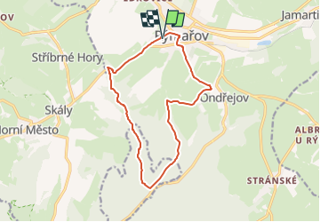
8,2 km | 10 km-effort
2h 15min
![](https://static1.geolcdn.com/siteimages/upload/files/16400158638029165_repeat_loop_refresh_sync_direction_icon.png)
Ja
![Tour Zu Fuß Breitenau - NS Široká Niva - Photo](https://media.geolcdn.com/t/375/260/59f014ae-529f-4445-b235-27b833b97de8.jpeg&format=jpg&maxdim=2)
![Zu Fuß Zu Fuß](https://static1.geolcdn.com/sitytour/trail-icons/100.png)
NS Široká Niva
Zu Fuß
Einfach
Breitenau,
Mährisch-Schlesien,
Mährisch-Schlesische Region,
Czech Republic
![](/images/other/stat-length.png)
6,9 km | 8,2 km-effort
1h 52min
![](https://static1.geolcdn.com/siteimages/upload/files/16400158638029165_repeat_loop_refresh_sync_direction_icon.png)
Nein
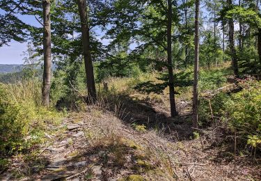
![Tour Zu Fuß Reitendorf - [Ž] - Photo](https://media.geolcdn.com/t/375/260/ca426870-e86c-4a96-bde0-2f91190915ef.jpeg&format=jpg&maxdim=2)
![Zu Fuß Zu Fuß](https://static1.geolcdn.com/sitytour/trail-icons/100.png)
[Ž]
Zu Fuß
Einfach
Reitendorf,
Mittelmähren,
Olmützer Region,
Czech Republic
![](/images/other/stat-length.png)
7,4 km | 11 km-effort
2h 29min
![](https://static1.geolcdn.com/siteimages/upload/files/16400158638029165_repeat_loop_refresh_sync_direction_icon.png)
Ja
![Tour Zu Fuß Klein Mohrau - Nová ves - Rýmařov - Photo](https://media.geolcdn.com/t/375/260/47c50813-5fcb-47f8-851e-4b2337df6fb6.jpeg&format=jpg&maxdim=2)
![Zu Fuß Zu Fuß](https://static1.geolcdn.com/sitytour/trail-icons/100.png)
Nová ves - Rýmařov
Zu Fuß
Einfach
Klein Mohrau,
Mährisch-Schlesien,
Mährisch-Schlesische Region,
Czech Republic
![](/images/other/stat-length.png)
8,9 km | 11,1 km-effort
2h 31min
![](https://static1.geolcdn.com/siteimages/upload/files/16400158638029165_repeat_loop_refresh_sync_direction_icon.png)
Nein
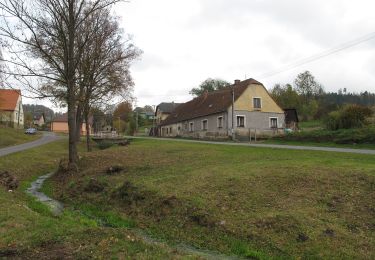
![Tour Zu Fuß Reitendorf - [M] - Photo](https://media.geolcdn.com/t/375/260/2389b978-f881-4d49-8011-c5e6270880f1.jpeg&format=jpg&maxdim=2)
![Zu Fuß Zu Fuß](https://static1.geolcdn.com/sitytour/trail-icons/100.png)
[M]
Zu Fuß
Einfach
Reitendorf,
Mittelmähren,
Olmützer Region,
Czech Republic
![](/images/other/stat-length.png)
5,4 km | 9,4 km-effort
2h 8min
![](https://static1.geolcdn.com/siteimages/upload/files/16400158638029165_repeat_loop_refresh_sync_direction_icon.png)
Nein
![Tour Zu Fuß Reitendorf - naučná stezka Bukovka - Photo](https://media.geolcdn.com/t/375/260/ca426870-e86c-4a96-bde0-2f91190915ef.jpeg&format=jpg&maxdim=2)
![Zu Fuß Zu Fuß](https://static1.geolcdn.com/sitytour/trail-icons/100.png)
naučná stezka Bukovka
Zu Fuß
Einfach
Reitendorf,
Mittelmähren,
Olmützer Region,
Czech Republic
![](/images/other/stat-length.png)
7,4 km | 11 km-effort
2h 29min
![](https://static1.geolcdn.com/siteimages/upload/files/16400158638029165_repeat_loop_refresh_sync_direction_icon.png)
Ja
![Tour Zu Fuß Dittersdorf a. d. Fister - NS Panské louky - Photo](https://media.geolcdn.com/t/375/260/351198c5-6baa-4cb8-bb44-20921655432e.jpeg&format=jpg&maxdim=2)
![Zu Fuß Zu Fuß](https://static1.geolcdn.com/sitytour/trail-icons/100.png)
NS Panské louky
Zu Fuß
Einfach
Dittersdorf a. d. Fister,
Mährisch-Schlesien,
Mährisch-Schlesische Region,
Czech Republic
![](/images/other/stat-length.png)
3,3 km | 4,6 km-effort
1h 3min
![](https://static1.geolcdn.com/siteimages/upload/files/16400158638029165_repeat_loop_refresh_sync_direction_icon.png)
Nein
![Tour Zu Fuß Raase - NS Po vulkanitech - Photo](https://media.geolcdn.com/t/375/260/a7fb9482-6350-462b-b9c9-cd7324a11411.jpeg&format=jpg&maxdim=2)
![Zu Fuß Zu Fuß](https://static1.geolcdn.com/sitytour/trail-icons/100.png)
NS Po vulkanitech
Zu Fuß
Einfach
Raase,
Mährisch-Schlesien,
Mährisch-Schlesische Region,
Czech Republic
![](/images/other/stat-length.png)
5,8 km | 7,5 km-effort
1h 42min
![](https://static1.geolcdn.com/siteimages/upload/files/16400158638029165_repeat_loop_refresh_sync_direction_icon.png)
Nein
![Tour Zu Fuß Lipina - červený místní okruh okolo Dolního žlebu - Photo](https://media.geolcdn.com/t/375/260/13934684-c548-48eb-86a5-4fd735f5e76b.jpeg&format=jpg&maxdim=2)
![Zu Fuß Zu Fuß](https://static1.geolcdn.com/sitytour/trail-icons/100.png)
červený místní okruh okolo Dolního žlebu
Zu Fuß
Einfach
Lipina,
Mittelmähren,
Olmützer Region,
Czech Republic
![](/images/other/stat-length.png)
5,9 km | 8,8 km-effort
1h 59min
![](https://static1.geolcdn.com/siteimages/upload/files/16400158638029165_repeat_loop_refresh_sync_direction_icon.png)
Nein