


8,3 km | 10,7 km-effort
![Tour Zu Fuß Milkendorf - [M] Milotice nad Opavou - Krnov - Photo](https://media.geolcdn.com/t/1900/400/8e7566ad-25ee-42af-96bf-113d9a2183cc.jpeg&format=pjpeg&maxdim=2)

Tous les sentiers balisés d’Europe GUIDE+


Kostenlosegpshiking-Anwendung
 SityTrail
IGN / Geografische Institute
SityTrail World
Die Welt öffnet sich für Sie
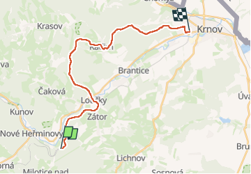
Tour Zu Fuß von 21 km verfügbar auf Mährisch-Schlesien, Mährisch-Schlesische Region, Milkendorf. Diese Tour wird von SityTrail - itinéraires balisés pédestres vorgeschlagen.
Tour erstellt von cz:KČT.
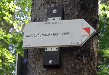
![Tour Zu Fuß Milkendorf - [M] Milotice nad Opavou - Krnov - Photo 1](https://media.geolcdn.com/t/2048/auto/2f0439af-6bc5-45e5-9ea7-0ae53d3b7b17.jpeg&format=jpg&maxdim=0 "Tour Zu Fuß Milkendorf - [M] Milotice nad Opavou - Krnov - Photo 1")
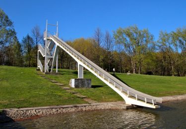
![Tour Zu Fuß Milkendorf - [M] Milotice nad Opavou - Krnov - Photo 2](https://media.geolcdn.com/t/2048/auto/bdd321e9-a751-4aee-91f3-5ff8a4688f5f.jpeg&format=jpg&maxdim=0 "Tour Zu Fuß Milkendorf - [M] Milotice nad Opavou - Krnov - Photo 2")
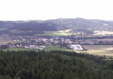
![Tour Zu Fuß Milkendorf - [M] Milotice nad Opavou - Krnov - Photo 3](https://media.geolcdn.com/t/2048/auto/efcba984-348f-4d69-8352-31d220eb550b.jpeg&format=jpg&maxdim=0 "Tour Zu Fuß Milkendorf - [M] Milotice nad Opavou - Krnov - Photo 3")
![Tour Zu Fuß Milkendorf - [M] Milotice nad Opavou - Krnov - Photo 4](https://media.geolcdn.com/t/2048/auto/1a6b9b25-eadd-4735-9497-0e345264033f.jpeg&format=jpg&maxdim=0 "Tour Zu Fuß Milkendorf - [M] Milotice nad Opavou - Krnov - Photo 4")
![Tour Zu Fuß Milkendorf - [M] Milotice nad Opavou - Krnov - Photo 5](https://media.geolcdn.com/t/2048/auto/93032230-a6c1-405b-bc9b-df5581ac8d8a.jpeg&format=jpg&maxdim=0 "Tour Zu Fuß Milkendorf - [M] Milotice nad Opavou - Krnov - Photo 5")
![Tour Zu Fuß Milkendorf - [M] Milotice nad Opavou - Krnov - Photo 6](https://media.geolcdn.com/t/2048/auto/9294c5b7-4536-4c66-b614-ffd351cf4c93.jpeg&format=jpg&maxdim=0 "Tour Zu Fuß Milkendorf - [M] Milotice nad Opavou - Krnov - Photo 6")
![Tour Zu Fuß Milkendorf - [M] Milotice nad Opavou - Krnov - Photo 7](https://media.geolcdn.com/t/2048/auto/092ce3fd-68bd-48c5-90c0-4ed0f6bd5c83.jpeg&format=jpg&maxdim=0 "Tour Zu Fuß Milkendorf - [M] Milotice nad Opavou - Krnov - Photo 7")
![Tour Zu Fuß Milkendorf - [M] Milotice nad Opavou - Krnov - Photo 8](https://media.geolcdn.com/t/2048/auto/d8c4aee9-bd5c-458b-bd27-97f5ae62ee0d.jpeg&format=jpg&maxdim=0 "Tour Zu Fuß Milkendorf - [M] Milotice nad Opavou - Krnov - Photo 8")
![Tour Zu Fuß Milkendorf - [M] Milotice nad Opavou - Krnov - Photo 9](https://media.geolcdn.com/t/2048/auto/56275e8a-d233-4dd0-805b-efad9fa8416c.jpeg&format=jpg&maxdim=0 "Tour Zu Fuß Milkendorf - [M] Milotice nad Opavou - Krnov - Photo 9")
![Tour Zu Fuß Milkendorf - [M] Milotice nad Opavou - Krnov - Photo 10](https://media.geolcdn.com/t/2048/auto/8e7566ad-25ee-42af-96bf-113d9a2183cc.jpeg&format=jpg&maxdim=0 "Tour Zu Fuß Milkendorf - [M] Milotice nad Opavou - Krnov - Photo 10")
![Tour Zu Fuß Karlsbrunn - [Č] Malá Morávka - Karlova Studánka - Photo](https://media.geolcdn.com/t/375/260/81acd68f-f183-4dc5-8d51-dbab62c604d5.jpeg&format=jpg&maxdim=2)
Zu Fuß
![Tour Zu Fuß Jägerndorf - [Č] okruh kolem Krnova - Photo](https://media.geolcdn.com/t/375/260/0c9d8cbf-3608-4e3b-bb39-83d0370a4b42.jpeg&format=jpg&maxdim=2)
Zu Fuß
![Tour Zu Fuß Olbersdorf - [Ž] Albrechtice - Petrovy boudy - Photo](https://media.geolcdn.com/t/375/260/f4747928-09d6-4159-b288-1d744968c1cc.jpeg&format=jpg&maxdim=2)
Zu Fuß
Zu Fuß
![Tour Zu Fuß Engelsberg - [Ž] Ovčárna - Brantice - Photo](https://media.geolcdn.com/t/375/260/56802721-ae92-4609-a4ba-e69adace9f31.jpeg&format=jpg&maxdim=2)
Zu Fuß
Zu Fuß
Zu Fuß
Zu Fuß
Zu Fuß