![](/images/other/stat-length.png)
![Tour Zu Fuß Moldautein - NS Semenec - Photo](https://media.geolcdn.com/t/1900/400/bcf24466-81fb-477e-8bb1-5c928c36b879.jpeg&format=pjpeg&maxdim=2)
NS Semenec
SityTrail - itinéraires balisés pédestres
Tous les sentiers balisés d’Europe GUIDE+
![Länge](/images/other/stat-length.png)
Länge
5,2 km
![Maximale Höhe](https://static1.geolcdn.com/siteimages/upload/files/1508320355ic_sort_altitude_max_24dp.png)
Maximale Höhe
454 m
![Positive Höhendifferenz](https://static1.geolcdn.com/siteimages/upload/files/1508320355ic_sort_den_pos_24dp.png)
Positive Höhendifferenz
120 m
![Km-Effort](/images/other/stat-length.png)
Km-Effort
6,7 km
![Min. Höhe](https://static1.geolcdn.com/siteimages/upload/files/1508320355ic_sort_altitude_min_24dp.png)
Min. Höhe
383 m
![Negative Höhendifferenz](https://static1.geolcdn.com/siteimages/upload/files/1508320355ic_sort_den_neg_24dp.png)
Negative Höhendifferenz
119 m
![Boucle](https://static1.geolcdn.com/siteimages/upload/files/16400158638029165_repeat_loop_refresh_sync_direction_icon.png)
Boucle
Ja
Kennzeichnung
Erstellungsdatum :
2025-02-07 02:25:19.337
Letzte Änderung :
2025-02-07 02:25:19.337
![Zu Fuß](https://static1.geolcdn.com/sitytour/trail-icons/100.png)
1h32
Schwierigkeit : Einfach
![Scannen Sie diesen QR-Code, um die Tour in der SityTrail-Anwendung zu öffnen](https://capi.geolives.com/qq0zvz2zws4bq2lad0pu/sitytour/trails/4344458/qr.png?size=200)
Kostenlosegpshiking-Anwendung
Über SityTrail
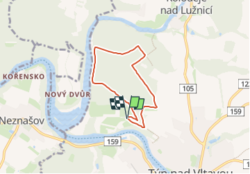
Tour Zu Fuß von 5,2 km verfügbar auf Südwesten, Südböhmische Region, Moldautein. Diese Tour wird von SityTrail - itinéraires balisés pédestres vorgeschlagen.
Beschreibung
Tour erstellt von cz:KČT.
Ort
Land:
Czech Republic
Region :
Südwesten
Abteilung/Provinz :
Südböhmische Region
Kommune :
Moldautein
Standort:
Unknown
Gehen Sie:(Dec)
Gehen Sie:(UTM)
456719 ; 5453450 (33U) N.
Kommentare
Touren in der Umgebung
![Tour Zu Fuß Protiwin - NS Zelendárky - Photo](https://media.geolcdn.com/t/375/260/83701df3-5317-4a0c-88bc-47a7676e831d.jpeg&format=jpg&maxdim=2)
![Zu Fuß Zu Fuß](https://static1.geolcdn.com/sitytour/trail-icons/100.png)
NS Zelendárky
Zu Fuß
Einfach
Protiwin,
Südwesten,
Südböhmische Region,
Czech Republic
![](/images/other/stat-length.png)
11,6 km | 13,6 km-effort
3h 6min
![](https://static1.geolcdn.com/siteimages/upload/files/16400158638029165_repeat_loop_refresh_sync_direction_icon.png)
Nein
![Tour Zu Fuß Protiwin - NS Na břehu Blanice - Photo](https://media.geolcdn.com/t/375/260/c5e552ff-0d5d-4a3f-acdd-499ba877ee3a.jpeg&format=jpg&maxdim=2)
![Zu Fuß Zu Fuß](https://static1.geolcdn.com/sitytour/trail-icons/100.png)
NS Na břehu Blanice
Zu Fuß
Medium
Protiwin,
Südwesten,
Südböhmische Region,
Czech Republic
![](/images/other/stat-length.png)
22 km | 25 km-effort
5h 39min
![](https://static1.geolcdn.com/siteimages/upload/files/16400158638029165_repeat_loop_refresh_sync_direction_icon.png)
Ja
![Tour Zu Fuß Pisek - Cesta drahokamů - Photo](https://media.geolcdn.com/t/375/260/c272ea0a-0350-4540-a394-87960286de9a.jpeg&format=jpg&maxdim=2)
![Zu Fuß Zu Fuß](https://static1.geolcdn.com/sitytour/trail-icons/100.png)
Cesta drahokamů
Zu Fuß
Einfach
Pisek,
Südwesten,
Südböhmische Region,
Czech Republic
![](/images/other/stat-length.png)
6,1 km | 9 km-effort
2h 3min
![](https://static1.geolcdn.com/siteimages/upload/files/16400158638029165_repeat_loop_refresh_sync_direction_icon.png)
Nein
![Tour Zu Fuß Borkowitz - NS Borkovická blata - Photo](https://media.geolcdn.com/t/375/260/c563f894-9ce5-4c9a-b01b-ae6aa8b9a031.jpeg&format=jpg&maxdim=2)
![Zu Fuß Zu Fuß](https://static1.geolcdn.com/sitytour/trail-icons/100.png)
NS Borkovická blata
Zu Fuß
Einfach
Borkowitz,
Südwesten,
Südböhmische Region,
Czech Republic
![](/images/other/stat-length.png)
3,7 km | 4 km-effort
54min
![](https://static1.geolcdn.com/siteimages/upload/files/16400158638029165_repeat_loop_refresh_sync_direction_icon.png)
Nein
![Tour Zu Fuß Schewetin - [M] Ševětín - Velechvín - Photo](https://media.geolcdn.com/t/375/260/bce36fe7-b4ce-4198-93e2-1fa19f3b88bb.jpeg&format=jpg&maxdim=2)
![Zu Fuß Zu Fuß](https://static1.geolcdn.com/sitytour/trail-icons/100.png)
[M] Ševětín - Velechvín
Zu Fuß
Einfach
Schewetin,
Südwesten,
Südböhmische Region,
Czech Republic
![](/images/other/stat-length.png)
8 km | 9,7 km-effort
2h 12min
![](https://static1.geolcdn.com/siteimages/upload/files/16400158638029165_repeat_loop_refresh_sync_direction_icon.png)
Nein
![Tour Zu Fuß Pisek - [M] Smrkovice - Protivín - Photo](https://media.geolcdn.com/t/375/260/0e1a79da-d78d-470d-ae1f-52194443f13d.jpeg&format=jpg&maxdim=2)
![Zu Fuß Zu Fuß](https://static1.geolcdn.com/sitytour/trail-icons/100.png)
[M] Smrkovice - Protivín
Zu Fuß
Einfach
Pisek,
Südwesten,
Südböhmische Region,
Czech Republic
![](/images/other/stat-length.png)
9,5 km | 11,3 km-effort
2h 34min
![](https://static1.geolcdn.com/siteimages/upload/files/16400158638029165_repeat_loop_refresh_sync_direction_icon.png)
Nein
![Tour Zu Fuß Branice - NS Vejrovského zemanství - Photo](https://media.geolcdn.com/t/375/260/c9857817-7111-4ef9-8729-20b716f6138c.jpeg&format=jpg&maxdim=2)
![Zu Fuß Zu Fuß](https://static1.geolcdn.com/sitytour/trail-icons/100.png)
NS Vejrovského zemanství
Zu Fuß
Einfach
Branice,
Südwesten,
Südböhmische Region,
Czech Republic
![](/images/other/stat-length.png)
13,1 km | 15,6 km-effort
3h 32min
![](https://static1.geolcdn.com/siteimages/upload/files/16400158638029165_repeat_loop_refresh_sync_direction_icon.png)
Ja
![Tour Zu Fuß Woslau - Naučná stezka Partyzánská - Photo](https://media.geolcdn.com/t/375/260/25e1aae0-f949-41ae-abd5-a60d88ad34ee.jpeg&format=jpg&maxdim=2)
![Zu Fuß Zu Fuß](https://static1.geolcdn.com/sitytour/trail-icons/100.png)
Naučná stezka Partyzánská
Zu Fuß
Einfach
Woslau,
Südwesten,
Südböhmische Region,
Czech Republic
![](/images/other/stat-length.png)
6 km | 7,2 km-effort
1h 38min
![](https://static1.geolcdn.com/siteimages/upload/files/16400158638029165_repeat_loop_refresh_sync_direction_icon.png)
Ja
![Tour Zu Fuß Vrcovice - [Z] Na Ptáčkovně - Pod Bohuslavcem - Photo](https://media.geolcdn.com/t/375/260/cb7dd3a0-b882-4d93-a910-805045955afa.jpeg&format=jpg&maxdim=2)
![Zu Fuß Zu Fuß](https://static1.geolcdn.com/sitytour/trail-icons/100.png)
[Z] Na Ptáčkovně - Pod Bohuslavcem
Zu Fuß
Einfach
Vrcovice,
Südwesten,
Südböhmische Region,
Czech Republic
![](/images/other/stat-length.png)
5,2 km | 7,3 km-effort
1h 39min
![](https://static1.geolcdn.com/siteimages/upload/files/16400158638029165_repeat_loop_refresh_sync_direction_icon.png)
Nein