![](/images/other/stat-length.png)
![Tour Zu Fuß Ludwigsthal - Vyhlídka na Zámecké hoře a zřícenina hradu Fürstenwalde - Photo](https://media.geolcdn.com/t/1900/400/33b3ae1b-dcde-43d3-8153-ab27854678a5.jpeg&format=pjpeg&maxdim=2)
Vyhlídka na Zámecké hoře a zřícenina hradu Fürstenwalde
SityTrail - itinéraires balisés pédestres
Tous les sentiers balisés d’Europe GUIDE+
![Länge](/images/other/stat-length.png)
Länge
3,5 km
![Maximale Höhe](https://static1.geolcdn.com/siteimages/upload/files/1508320355ic_sort_altitude_max_24dp.png)
Maximale Höhe
846 m
![Positive Höhendifferenz](https://static1.geolcdn.com/siteimages/upload/files/1508320355ic_sort_den_pos_24dp.png)
Positive Höhendifferenz
269 m
![Km-Effort](/images/other/stat-length.png)
Km-Effort
6,9 km
![Min. Höhe](https://static1.geolcdn.com/siteimages/upload/files/1508320355ic_sort_altitude_min_24dp.png)
Min. Höhe
570 m
![Negative Höhendifferenz](https://static1.geolcdn.com/siteimages/upload/files/1508320355ic_sort_den_neg_24dp.png)
Negative Höhendifferenz
223 m
![Boucle](https://static1.geolcdn.com/siteimages/upload/files/16400158638029165_repeat_loop_refresh_sync_direction_icon.png)
Boucle
Nein
Kennzeichnung
Erstellungsdatum :
2025-02-07 01:42:11.933
Letzte Änderung :
2025-02-07 01:42:11.933
![Zu Fuß](https://static1.geolcdn.com/sitytour/trail-icons/100.png)
1h34
Schwierigkeit : Einfach
![Scannen Sie diesen QR-Code, um die Tour in der SityTrail-Anwendung zu öffnen](https://capi.geolives.com/qq0zvz2zws4bq2lad0pu/sitytour/trails/4344417/qr.png?size=200)
Kostenlosegpshiking-Anwendung
Über SityTrail
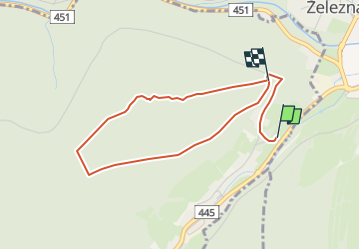
Tour Zu Fuß von 3,5 km verfügbar auf Mährisch-Schlesien, Mährisch-Schlesische Region, Ludwigsthal. Diese Tour wird von SityTrail - itinéraires balisés pédestres vorgeschlagen.
Beschreibung
Tour erstellt von cz:KČT.
Ort
Land:
Czech Republic
Region :
Mährisch-Schlesien
Abteilung/Provinz :
Mährisch-Schlesische Region
Kommune :
Ludwigsthal
Standort:
Unknown
Gehen Sie:(Dec)
Gehen Sie:(UTM)
668512 ; 5554697 (33U) N.
Kommentare
Touren in der Umgebung
![Tour Zu Fuß Zuckmantel - Zlatohorská hornická naučná stezka - Photo](https://media.geolcdn.com/t/375/260/c9f29190-4316-4e50-8642-8b3642d2e474.jpeg&format=jpg&maxdim=2)
![Zu Fuß Zu Fuß](https://static1.geolcdn.com/sitytour/trail-icons/100.png)
Zlatohorská hornická naučná stezka
Zu Fuß
Medium
Zuckmantel,
Mittelmähren,
Olmützer Region,
Czech Republic
![](/images/other/stat-length.png)
16,5 km | 25 km-effort
5h 36min
![](https://static1.geolcdn.com/siteimages/upload/files/16400158638029165_repeat_loop_refresh_sync_direction_icon.png)
Ja
![Tour Zu Fuß Karlsbrunn - [Č] Malá Morávka - Karlova Studánka - Photo](https://media.geolcdn.com/t/375/260/81acd68f-f183-4dc5-8d51-dbab62c604d5.jpeg&format=jpg&maxdim=2)
![Zu Fuß Zu Fuß](https://static1.geolcdn.com/sitytour/trail-icons/100.png)
[Č] Malá Morávka - Karlova Studánka
Zu Fuß
Einfach
Karlsbrunn,
Mährisch-Schlesien,
Mährisch-Schlesische Region,
Czech Republic
![](/images/other/stat-length.png)
8,3 km | 10,7 km-effort
2h 25min
![](https://static1.geolcdn.com/siteimages/upload/files/16400158638029165_repeat_loop_refresh_sync_direction_icon.png)
Nein
![Tour Zu Fuß Milkendorf - [M] Milotice nad Opavou - Krnov - Photo](https://media.geolcdn.com/t/375/260/8e7566ad-25ee-42af-96bf-113d9a2183cc.jpeg&format=jpg&maxdim=2)
![Zu Fuß Zu Fuß](https://static1.geolcdn.com/sitytour/trail-icons/100.png)
[M] Milotice nad Opavou - Krnov
Zu Fuß
Medium
Milkendorf,
Mährisch-Schlesien,
Mährisch-Schlesische Region,
Czech Republic
![](/images/other/stat-length.png)
21 km | 29 km-effort
6h 32min
![](https://static1.geolcdn.com/siteimages/upload/files/16400158638029165_repeat_loop_refresh_sync_direction_icon.png)
Nein
![Tour Zu Fuß Olbersdorf - [Ž] Albrechtice - Petrovy boudy - Photo](https://media.geolcdn.com/t/375/260/f4747928-09d6-4159-b288-1d744968c1cc.jpeg&format=jpg&maxdim=2)
![Zu Fuß Zu Fuß](https://static1.geolcdn.com/sitytour/trail-icons/100.png)
[Ž] Albrechtice - Petrovy boudy
Zu Fuß
Schwierig
Olbersdorf,
Mährisch-Schlesien,
Mährisch-Schlesische Region,
Czech Republic
![](/images/other/stat-length.png)
22 km | 33 km-effort
7h 25min
![](https://static1.geolcdn.com/siteimages/upload/files/16400158638029165_repeat_loop_refresh_sync_direction_icon.png)
Nein
![Tour Zu Fuß Nieder Lindewiese - [Č] Lázně Lipová - Dolní Lipová - Photo](https://media.geolcdn.com/t/375/260/89666500-85c0-4bea-897f-f89baf646252.jpeg&format=jpg&maxdim=2)
![Zu Fuß Zu Fuß](https://static1.geolcdn.com/sitytour/trail-icons/100.png)
[Č] Lázně Lipová - Dolní Lipová
Zu Fuß
Einfach
Nieder Lindewiese,
Mittelmähren,
Olmützer Region,
Czech Republic
![](/images/other/stat-length.png)
3,8 km | 4,5 km-effort
1h 0min
![](https://static1.geolcdn.com/siteimages/upload/files/16400158638029165_repeat_loop_refresh_sync_direction_icon.png)
Nein
![Tour Zu Fuß Nieder Lindewiese - [Z] Ramzová - Obří skály - Photo](https://media.geolcdn.com/t/375/260/2e4c1233-6967-40e1-b71d-3baad939719d.jpeg&format=jpg&maxdim=2)
![Zu Fuß Zu Fuß](https://static1.geolcdn.com/sitytour/trail-icons/100.png)
[Z] Ramzová - Obří skály
Zu Fuß
Einfach
Nieder Lindewiese,
Mittelmähren,
Olmützer Region,
Czech Republic
![](/images/other/stat-length.png)
5 km | 7,2 km-effort
1h 38min
![](https://static1.geolcdn.com/siteimages/upload/files/16400158638029165_repeat_loop_refresh_sync_direction_icon.png)
Nein
![Tour Zu Fuß Wermsdorf - [M] U Františkovy myslivny - Kosaře - Photo](https://media.geolcdn.com/t/375/260/43aa4f93-e934-4aa4-a34b-03b734430cad.jpeg&format=jpg&maxdim=2)
![Zu Fuß Zu Fuß](https://static1.geolcdn.com/sitytour/trail-icons/100.png)
[M] U Františkovy myslivny - Kosaře
Zu Fuß
Einfach
Wermsdorf,
Mittelmähren,
Olmützer Region,
Czech Republic
![](/images/other/stat-length.png)
7,9 km | 13,5 km-effort
3h 4min
![](https://static1.geolcdn.com/siteimages/upload/files/16400158638029165_repeat_loop_refresh_sync_direction_icon.png)
Nein
![Tour Zu Fuß Engelsberg - [Ž] Ovčárna - Brantice - Photo](https://media.geolcdn.com/t/375/260/56802721-ae92-4609-a4ba-e69adace9f31.jpeg&format=jpg&maxdim=2)
![Zu Fuß Zu Fuß](https://static1.geolcdn.com/sitytour/trail-icons/100.png)
[Ž] Ovčárna - Brantice
Zu Fuß
Schwierig
Engelsberg,
Mährisch-Schlesien,
Mährisch-Schlesische Region,
Czech Republic
![](/images/other/stat-length.png)
23 km | 35 km-effort
8h 3min
![](https://static1.geolcdn.com/siteimages/upload/files/16400158638029165_repeat_loop_refresh_sync_direction_icon.png)
Nein
![Tour Zu Fuß Nieder Lindewiese - NS Johanna Schrotha - Photo](https://media.geolcdn.com/t/375/260/ext.jpg?maxdim=2&url=https%3A%2F%2Fstatic1.geolcdn.com%2Fsiteimages%2Fupload%2Ffiles%2F1545311037marcheuse_200dpi.jpg)
![Zu Fuß Zu Fuß](https://static1.geolcdn.com/sitytour/trail-icons/100.png)
NS Johanna Schrotha
Zu Fuß
Einfach
Nieder Lindewiese,
Mittelmähren,
Olmützer Region,
Czech Republic
![](/images/other/stat-length.png)
9 km | 12,3 km-effort
2h 47min
![](https://static1.geolcdn.com/siteimages/upload/files/16400158638029165_repeat_loop_refresh_sync_direction_icon.png)
Nein