


8,3 km | 10,7 km-effort
![Tour Zu Fuß Wermsdorf - [M] U Františkovy myslivny - Kosaře - Photo](https://media.geolcdn.com/t/1900/400/43aa4f93-e934-4aa4-a34b-03b734430cad.jpeg&format=pjpeg&maxdim=2)

Tous les sentiers balisés d’Europe GUIDE+


Kostenlosegpshiking-Anwendung
 SityTrail
IGN / Geografische Institute
SityTrail World
Die Welt öffnet sich für Sie
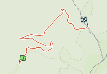
Tour Zu Fuß von 7,9 km verfügbar auf Mittelmähren, Olmützer Region, Wermsdorf. Diese Tour wird von SityTrail - itinéraires balisés pédestres vorgeschlagen.
Tour erstellt von cz:KČT.
![Tour Zu Fuß Wermsdorf - [M] U Františkovy myslivny - Kosaře - Photo 1](https://media.geolcdn.com/t/2048/auto/9a40e141-43d5-428d-8b46-43c8fac7a443.jpeg&format=jpg&maxdim=0 "Tour Zu Fuß Wermsdorf - [M] U Františkovy myslivny - Kosaře - Photo 1")
![Tour Zu Fuß Wermsdorf - [M] U Františkovy myslivny - Kosaře - Photo 2](https://media.geolcdn.com/t/2048/auto/4230c907-c39c-4bc2-96b9-d3a762b690d6.jpeg&format=jpg&maxdim=0 "Tour Zu Fuß Wermsdorf - [M] U Františkovy myslivny - Kosaře - Photo 2")
![Tour Zu Fuß Wermsdorf - [M] U Františkovy myslivny - Kosaře - Photo 3](https://media.geolcdn.com/t/2048/auto/e4ba43f9-8953-4e73-a034-3987d31f11a2.jpeg&format=jpg&maxdim=0 "Tour Zu Fuß Wermsdorf - [M] U Františkovy myslivny - Kosaře - Photo 3")
![Tour Zu Fuß Wermsdorf - [M] U Františkovy myslivny - Kosaře - Photo 4](https://media.geolcdn.com/t/2048/auto/e05df720-8d1a-4698-b2f5-546ac421bfa9.jpeg&format=jpg&maxdim=0 "Tour Zu Fuß Wermsdorf - [M] U Františkovy myslivny - Kosaře - Photo 4")
![Tour Zu Fuß Wermsdorf - [M] U Františkovy myslivny - Kosaře - Photo 5](https://media.geolcdn.com/t/2048/auto/360d61a9-50d3-4e59-b1eb-a21950efc58f.jpeg&format=jpg&maxdim=0 "Tour Zu Fuß Wermsdorf - [M] U Františkovy myslivny - Kosaře - Photo 5")
![Tour Zu Fuß Wermsdorf - [M] U Františkovy myslivny - Kosaře - Photo 6](https://media.geolcdn.com/t/2048/auto/2aaaea08-1229-433b-af99-02c1c6be70a1.jpeg&format=jpg&maxdim=0 "Tour Zu Fuß Wermsdorf - [M] U Františkovy myslivny - Kosaře - Photo 6")
![Tour Zu Fuß Wermsdorf - [M] U Františkovy myslivny - Kosaře - Photo 7](https://media.geolcdn.com/t/2048/auto/98385d20-7ccc-4b59-839a-efd5be86126d.jpeg&format=jpg&maxdim=0 "Tour Zu Fuß Wermsdorf - [M] U Františkovy myslivny - Kosaře - Photo 7")
![Tour Zu Fuß Wermsdorf - [M] U Františkovy myslivny - Kosaře - Photo 8](https://media.geolcdn.com/t/2048/auto/48d3ce71-88ad-4aa3-a80d-c585499ff8a3.jpeg&format=jpg&maxdim=0 "Tour Zu Fuß Wermsdorf - [M] U Františkovy myslivny - Kosaře - Photo 8")
![Tour Zu Fuß Wermsdorf - [M] U Františkovy myslivny - Kosaře - Photo 9](https://media.geolcdn.com/t/2048/auto/cd10ad46-898e-4577-8bae-721301624666.jpeg&format=jpg&maxdim=0 "Tour Zu Fuß Wermsdorf - [M] U Františkovy myslivny - Kosaře - Photo 9")
![Tour Zu Fuß Wermsdorf - [M] U Františkovy myslivny - Kosaře - Photo 10](https://media.geolcdn.com/t/2048/auto/43aa4f93-e934-4aa4-a34b-03b734430cad.jpeg&format=jpg&maxdim=0 "Tour Zu Fuß Wermsdorf - [M] U Františkovy myslivny - Kosaře - Photo 10")
![Tour Zu Fuß Karlsbrunn - [Č] Malá Morávka - Karlova Studánka - Photo](https://media.geolcdn.com/t/375/260/81acd68f-f183-4dc5-8d51-dbab62c604d5.jpeg&format=jpg&maxdim=2)
Zu Fuß
Zu Fuß
Zu Fuß
![Tour Zu Fuß Nieder Lindewiese - [Z] Ramzová - Obří skály - Photo](https://media.geolcdn.com/t/375/260/2e4c1233-6967-40e1-b71d-3baad939719d.jpeg&format=jpg&maxdim=2)
Zu Fuß
![Tour Zu Fuß Mährisch Altstadt - [Č] Staroměstský pevnostní okruh - Photo](https://media.geolcdn.com/t/375/260/0c86b44d-b49b-4018-84ce-ce37dde2e042.jpeg&format=jpg&maxdim=2)
Zu Fuß
![Tour Zu Fuß Mährisch Altstadt - [Z] Staré město - Paprsek - Photo](https://media.geolcdn.com/t/375/260/604b9227-619f-49ba-bc9e-bf5c48d6c7dd.jpeg&format=jpg&maxdim=2)
Zu Fuß
![Tour Zu Fuß Hannsdorf - [Ž] Sklené - Vysoké Žibřidovice - Photo](https://media.geolcdn.com/t/375/260/9ce39eb3-c6a7-4644-9f14-7d12e994714d.jpeg&format=jpg&maxdim=2)
Zu Fuß
![Tour Zu Fuß Engelsberg - [Ž] Ovčárna - Brantice - Photo](https://media.geolcdn.com/t/375/260/56802721-ae92-4609-a4ba-e69adace9f31.jpeg&format=jpg&maxdim=2)
Zu Fuß
![Tour Zu Fuß Mährisch Altstadt - [M] Pod Starým kopcem - Smrk - Photo](https://media.geolcdn.com/t/375/260/063f9983-27cc-4304-b95b-e36ef4c486f7.jpeg&format=jpg&maxdim=2)
Zu Fuß