![](/images/other/stat-length.png)
![Tour Zu Fuß Semil - NS Údolím Jizery - Riegrova stezka - Photo](https://media.geolcdn.com/t/1900/400/f28457de-1dd4-4d17-adda-244d66d45df5.jpeg&format=pjpeg&maxdim=2)
NS Údolím Jizery - Riegrova stezka
SityTrail - itinéraires balisés pédestres
Tous les sentiers balisés d’Europe GUIDE+
![Länge](/images/other/stat-length.png)
Länge
3,7 km
![Maximale Höhe](https://static1.geolcdn.com/siteimages/upload/files/1508320355ic_sort_altitude_max_24dp.png)
Maximale Höhe
371 m
![Positive Höhendifferenz](https://static1.geolcdn.com/siteimages/upload/files/1508320355ic_sort_den_pos_24dp.png)
Positive Höhendifferenz
107 m
![Km-Effort](/images/other/stat-length.png)
Km-Effort
5,2 km
![Min. Höhe](https://static1.geolcdn.com/siteimages/upload/files/1508320355ic_sort_altitude_min_24dp.png)
Min. Höhe
294 m
![Negative Höhendifferenz](https://static1.geolcdn.com/siteimages/upload/files/1508320355ic_sort_den_neg_24dp.png)
Negative Höhendifferenz
116 m
![Boucle](https://static1.geolcdn.com/siteimages/upload/files/16400158638029165_repeat_loop_refresh_sync_direction_icon.png)
Boucle
Nein
Kennzeichnung
Erstellungsdatum :
2025-02-07 00:11:46.868
Letzte Änderung :
2025-02-07 00:11:46.868
![Zu Fuß](https://static1.geolcdn.com/sitytour/trail-icons/100.png)
1h10
Schwierigkeit : Einfach
![Scannen Sie diesen QR-Code, um die Tour in der SityTrail-Anwendung zu öffnen](https://capi.geolives.com/qq0zvz2zws4bq2lad0pu/sitytour/trails/4344312/qr.png?size=200)
Kostenlosegpshiking-Anwendung
Über SityTrail
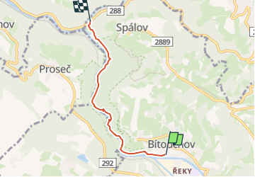
Tour Zu Fuß von 3,7 km verfügbar auf Nordosten, Reichenberger Region, Semil. Diese Tour wird von SityTrail - itinéraires balisés pédestres vorgeschlagen.
Beschreibung
Tour erstellt von cz:KČT.
Ort
Land:
Czech Republic
Region :
Nordosten
Abteilung/Provinz :
Reichenberger Region
Kommune :
Semil
Standort:
Unknown
Gehen Sie:(Dec)
Gehen Sie:(UTM)
522627 ; 5606995 (33U) N.
Kommentare
Touren in der Umgebung
![Tour Zu Fuß Chuchelna - [Ž] Tatobity (vodojem) - Kozákov - Photo](https://media.geolcdn.com/t/375/260/60a9145e-607c-4ea0-a933-69a7b1a00525.jpeg&format=jpg&maxdim=2)
![Zu Fuß Zu Fuß](https://static1.geolcdn.com/sitytour/trail-icons/100.png)
[Ž] Tatobity (vodojem) - Kozákov
Zu Fuß
Einfach
Chuchelna,
Nordosten,
Reichenberger Region,
Czech Republic
![](/images/other/stat-length.png)
3,1 km | 4,2 km-effort
56min
![](https://static1.geolcdn.com/siteimages/upload/files/16400158638029165_repeat_loop_refresh_sync_direction_icon.png)
Nein
![Tour Zu Fuß Mírová pod Kozákovem - NS Kozákov - Photo](https://media.geolcdn.com/t/375/260/30988289-477c-4312-8db4-29e06a5522c0.jpeg&format=jpg&maxdim=2)
![Zu Fuß Zu Fuß](https://static1.geolcdn.com/sitytour/trail-icons/100.png)
NS Kozákov
Zu Fuß
Einfach
Mírová pod Kozákovem,
Nordosten,
Reichenberger Region,
Czech Republic
![](/images/other/stat-length.png)
3,1 km | 5,9 km-effort
1h 21min
![](https://static1.geolcdn.com/siteimages/upload/files/16400158638029165_repeat_loop_refresh_sync_direction_icon.png)
Ja
![Tour Zu Fuß Semil - [Ž] Semily - Sejkorská kaple - Bitouchov - Photo](https://media.geolcdn.com/t/375/260/ad273ffb-8712-4976-94a1-7a2514a4e8d8.jpeg&format=jpg&maxdim=2)
![Zu Fuß Zu Fuß](https://static1.geolcdn.com/sitytour/trail-icons/100.png)
[Ž] Semily - Sejkorská kaple - Bitouchov
Zu Fuß
Einfach
Semil,
Nordosten,
Reichenberger Region,
Czech Republic
![](/images/other/stat-length.png)
8,1 km | 11 km-effort
2h 29min
![](https://static1.geolcdn.com/siteimages/upload/files/16400158638029165_repeat_loop_refresh_sync_direction_icon.png)
Nein
![Tour Zu Fuß Semil - [M] Semily - Nouzov - Photo](https://media.geolcdn.com/t/375/260/ad273ffb-8712-4976-94a1-7a2514a4e8d8.jpeg&format=jpg&maxdim=2)
![Zu Fuß Zu Fuß](https://static1.geolcdn.com/sitytour/trail-icons/100.png)
[M] Semily - Nouzov
Zu Fuß
Einfach
Semil,
Nordosten,
Reichenberger Region,
Czech Republic
![](/images/other/stat-length.png)
5,9 km | 8,6 km-effort
1h 56min
![](https://static1.geolcdn.com/siteimages/upload/files/16400158638029165_repeat_loop_refresh_sync_direction_icon.png)
Nein
![Tour Zu Fuß Boskau - NS Údolím Vošmendy - Photo](https://media.geolcdn.com/t/375/260/b95f7973-14a9-4ebe-8f71-115789124244.jpeg&format=jpg&maxdim=2)
![Zu Fuß Zu Fuß](https://static1.geolcdn.com/sitytour/trail-icons/100.png)
NS Údolím Vošmendy
Zu Fuß
Einfach
Boskau,
Nordosten,
Reichenberger Region,
Czech Republic
![](/images/other/stat-length.png)
4,3 km | 5,7 km-effort
1h 17min
![](https://static1.geolcdn.com/siteimages/upload/files/16400158638029165_repeat_loop_refresh_sync_direction_icon.png)
Nein
![Tour Zu Fuß Chuchelna - [Ž] Semily - U Krkavčí skály - Photo](https://media.geolcdn.com/t/375/260/a7e8cadb-e577-4017-bd0b-837334638646.jpeg&format=jpg&maxdim=2)
![Zu Fuß Zu Fuß](https://static1.geolcdn.com/sitytour/trail-icons/100.png)
[Ž] Semily - U Krkavčí skály
Zu Fuß
Einfach
Chuchelna,
Nordosten,
Reichenberger Region,
Czech Republic
![](/images/other/stat-length.png)
3,5 km | 4 km-effort
54min
![](https://static1.geolcdn.com/siteimages/upload/files/16400158638029165_repeat_loop_refresh_sync_direction_icon.png)
Nein
![Tour Zu Fuß Rostok - [Ž] Poniklá - Roztoky u Semil - Photo](https://media.geolcdn.com/t/375/260/84ad4702-43b8-450d-902b-9f2518462633.jpeg&format=jpg&maxdim=2)
![Zu Fuß Zu Fuß](https://static1.geolcdn.com/sitytour/trail-icons/100.png)
[Ž] Poniklá - Roztoky u Semil
Zu Fuß
Einfach
Rostok,
Nordosten,
Reichenberger Region,
Czech Republic
![](/images/other/stat-length.png)
10,4 km | 14,6 km-effort
3h 19min
![](https://static1.geolcdn.com/siteimages/upload/files/16400158638029165_repeat_loop_refresh_sync_direction_icon.png)
Nein
![Tour Zu Fuß Eisenbrod - [Z] Berany - Hrubá Horka - Photo](https://media.geolcdn.com/t/375/260/85b5fcbf-013c-4152-8474-e3ec21cfb00d.jpeg&format=jpg&maxdim=2)
![Zu Fuß Zu Fuß](https://static1.geolcdn.com/sitytour/trail-icons/100.png)
[Z] Berany - Hrubá Horka
Zu Fuß
Einfach
Eisenbrod,
Nordosten,
Reichenberger Region,
Czech Republic
![](/images/other/stat-length.png)
10,3 km | 17,6 km-effort
3h 59min
![](https://static1.geolcdn.com/siteimages/upload/files/16400158638029165_repeat_loop_refresh_sync_direction_icon.png)
Nein
![Tour Zu Fuß Eisenbrod - [M] Železný Brod - Bozkov - Photo](https://media.geolcdn.com/t/375/260/adb30047-d63e-4dac-9668-d1ce55b1c46f.jpeg&format=jpg&maxdim=2)
![Zu Fuß Zu Fuß](https://static1.geolcdn.com/sitytour/trail-icons/100.png)
[M] Železný Brod - Bozkov
Zu Fuß
Medium
Eisenbrod,
Nordosten,
Reichenberger Region,
Czech Republic
![](/images/other/stat-length.png)
17,1 km | 25 km-effort
5h 40min
![](https://static1.geolcdn.com/siteimages/upload/files/16400158638029165_repeat_loop_refresh_sync_direction_icon.png)
Nein