


8,8 km | 11,9 km-effort
![Tour Zu Fuß Frain an der Thaya - [Ž] Vranov nad Dyjí - okruh - Photo](https://media.geolcdn.com/t/1900/400/59f7bd35-0996-4a8b-b4dd-9275df0a0590.jpeg&format=pjpeg&maxdim=2)

Tous les sentiers balisés d’Europe GUIDE+


Kostenlosegpshiking-Anwendung
 SityTrail
IGN / Geografische Institute
SityTrail World
Die Welt öffnet sich für Sie
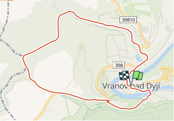
Tour Zu Fuß von 5,2 km verfügbar auf Südosten, Südmährische Region, Frain an der Thaya. Diese Tour wird von SityTrail - itinéraires balisés pédestres vorgeschlagen.
Tour erstellt von cz:KČT.
![Tour Zu Fuß Frain an der Thaya - [Ž] Vranov nad Dyjí - okruh - Photo 1](https://media.geolcdn.com/t/2048/auto/e94f6e44-16ce-41a9-93b5-d5c4c4a859f0.jpeg&format=jpg&maxdim=0 "Tour Zu Fuß Frain an der Thaya - [Ž] Vranov nad Dyjí - okruh - Photo 1")
![Tour Zu Fuß Frain an der Thaya - [Ž] Vranov nad Dyjí - okruh - Photo 2](https://media.geolcdn.com/t/2048/auto/1d2007e9-1b13-4156-a663-def8fd3579f6.jpeg&format=jpg&maxdim=0 "Tour Zu Fuß Frain an der Thaya - [Ž] Vranov nad Dyjí - okruh - Photo 2")
![Tour Zu Fuß Frain an der Thaya - [Ž] Vranov nad Dyjí - okruh - Photo 3](https://media.geolcdn.com/t/2048/auto/651aa3e6-83d4-4699-96d5-9be92b598e27.jpeg&format=jpg&maxdim=0 "Tour Zu Fuß Frain an der Thaya - [Ž] Vranov nad Dyjí - okruh - Photo 3")
![Tour Zu Fuß Frain an der Thaya - [Ž] Vranov nad Dyjí - okruh - Photo 4](https://media.geolcdn.com/t/2048/auto/ce037e42-f5e1-4bc8-b466-e140fc1af40f.jpeg&format=jpg&maxdim=0 "Tour Zu Fuß Frain an der Thaya - [Ž] Vranov nad Dyjí - okruh - Photo 4")
![Tour Zu Fuß Frain an der Thaya - [Ž] Vranov nad Dyjí - okruh - Photo 5](https://media.geolcdn.com/t/2048/auto/d878cfca-20d4-4680-ad3a-f19a78456472.jpeg&format=jpg&maxdim=0 "Tour Zu Fuß Frain an der Thaya - [Ž] Vranov nad Dyjí - okruh - Photo 5")
![Tour Zu Fuß Frain an der Thaya - [Ž] Vranov nad Dyjí - okruh - Photo 6](https://media.geolcdn.com/t/2048/auto/ca9151e2-7333-4e44-883d-767759caa06c.jpeg&format=jpg&maxdim=0 "Tour Zu Fuß Frain an der Thaya - [Ž] Vranov nad Dyjí - okruh - Photo 6")
![Tour Zu Fuß Frain an der Thaya - [Ž] Vranov nad Dyjí - okruh - Photo 7](https://media.geolcdn.com/t/2048/auto/b5e4db78-642a-434a-829f-8f757b12b7be.jpeg&format=jpg&maxdim=0 "Tour Zu Fuß Frain an der Thaya - [Ž] Vranov nad Dyjí - okruh - Photo 7")
![Tour Zu Fuß Frain an der Thaya - [Ž] Vranov nad Dyjí - okruh - Photo 8](https://media.geolcdn.com/t/2048/auto/fbd2799b-d5b4-4bd9-afb7-c876ec9401ce.jpeg&format=jpg&maxdim=0 "Tour Zu Fuß Frain an der Thaya - [Ž] Vranov nad Dyjí - okruh - Photo 8")
![Tour Zu Fuß Frain an der Thaya - [Ž] Vranov nad Dyjí - okruh - Photo 9](https://media.geolcdn.com/t/2048/auto/59f7bd35-0996-4a8b-b4dd-9275df0a0590.jpeg&format=jpg&maxdim=0 "Tour Zu Fuß Frain an der Thaya - [Ž] Vranov nad Dyjí - okruh - Photo 9")
![Tour Zu Fuß Frain an der Thaya - [Ž] Vranov nad Dyjí - okruh - Photo 10](https://media.geolcdn.com/t/2048/auto/1cc5f462-6505-4865-81f7-2cf1c12bc2ba.jpeg&format=jpg&maxdim=0 "Tour Zu Fuß Frain an der Thaya - [Ž] Vranov nad Dyjí - okruh - Photo 10")
Zu Fuß
![Tour Zu Fuß Gemeinde Hardegg - [M] Vranov nad Dyjí - Felling - Photo](https://media.geolcdn.com/t/375/260/e25aa64b-3028-4ec5-9b76-fe71ec93487f.jpeg&format=jpg&maxdim=2)
Zu Fuß
Zu Fuß
Zu Fuß
![Tour Zu Fuß Liliendorf - [Ž] Lesná - Ledové sluje - vyhlídka - Photo](https://media.geolcdn.com/t/375/260/ac13b2a6-a2a6-49b6-b151-4f6483ad5d2b.jpeg&format=jpg&maxdim=2)
Zu Fuß
![Tour Zu Fuß Schönwald - [M] Šumná - Hardegg - Photo](https://media.geolcdn.com/t/375/260/57463325-aa2b-454f-9571-0eca5929e103.jpeg&format=jpg&maxdim=2)
Zu Fuß
Zu Fuß