![](/images/other/stat-length.png)
![Tour Zu Fuß Lochnitz - [Ž] Lochenice - Probluz - Photo](https://media.geolcdn.com/t/1900/400/e0198ce6-f6ce-468c-878e-1878c36c0003.jpeg&format=pjpeg&maxdim=2)
[Ž] Lochenice - Probluz
SityTrail - itinéraires balisés pédestres
Tous les sentiers balisés d’Europe GUIDE+
![Länge](/images/other/stat-length.png)
Länge
14,5 km
![Maximale Höhe](https://static1.geolcdn.com/siteimages/upload/files/1508320355ic_sort_altitude_max_24dp.png)
Maximale Höhe
339 m
![Positive Höhendifferenz](https://static1.geolcdn.com/siteimages/upload/files/1508320355ic_sort_den_pos_24dp.png)
Positive Höhendifferenz
161 m
![Km-Effort](/images/other/stat-length.png)
Km-Effort
16,4 km
![Min. Höhe](https://static1.geolcdn.com/siteimages/upload/files/1508320355ic_sort_altitude_min_24dp.png)
Min. Höhe
238 m
![Negative Höhendifferenz](https://static1.geolcdn.com/siteimages/upload/files/1508320355ic_sort_den_neg_24dp.png)
Negative Höhendifferenz
102 m
![Boucle](https://static1.geolcdn.com/siteimages/upload/files/16400158638029165_repeat_loop_refresh_sync_direction_icon.png)
Boucle
Nein
Kennzeichnung
Erstellungsdatum :
2025-02-06 21:12:35.396
Letzte Änderung :
2025-02-06 21:12:35.396
![Zu Fuß](https://static1.geolcdn.com/sitytour/trail-icons/100.png)
3h43
Schwierigkeit : Einfach
![Scannen Sie diesen QR-Code, um die Tour in der SityTrail-Anwendung zu öffnen](https://capi.geolives.com/qq0zvz2zws4bq2lad0pu/sitytour/trails/4344100/qr.png?size=200)
Kostenlosegpshiking-Anwendung
Über SityTrail
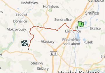
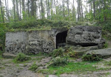
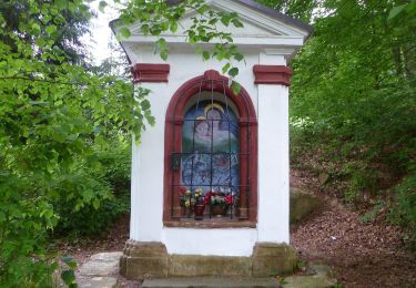
Tour Zu Fuß von 14,5 km verfügbar auf Nordosten, Königgrätzer Region, Lochnitz. Diese Tour wird von SityTrail - itinéraires balisés pédestres vorgeschlagen.
Beschreibung
Tour erstellt von cz:KČT.
Ort
Land:
Czech Republic
Region :
Nordosten
Abteilung/Provinz :
Königgrätzer Region
Kommune :
Lochnitz
Standort:
Unknown
Gehen Sie:(Dec)
Gehen Sie:(UTM)
559025 ; 5569273 (33U) N.
Kommentare
Touren in der Umgebung
![Tour Zu Fuß Horicka - Hořičky - Severní okruh - Photo](https://media.geolcdn.com/t/375/260/366b4ca6-f87c-4396-aca3-407199bc78bd.jpeg&format=jpg&maxdim=2)
![Zu Fuß Zu Fuß](https://static1.geolcdn.com/sitytour/trail-icons/100.png)
Hořičky - Severní okruh
Zu Fuß
Einfach
Horicka,
Nordosten,
Königgrätzer Region,
Czech Republic
![](/images/other/stat-length.png)
3,4 km | 4,2 km-effort
56min
![](https://static1.geolcdn.com/siteimages/upload/files/16400158638029165_repeat_loop_refresh_sync_direction_icon.png)
Nein
![Tour Zu Fuß Littitsch - [Z] Hřibojedy - Nouzov - Photo](https://media.geolcdn.com/t/375/260/8e4360c0-0f4f-4484-9216-784360d47d83.jpeg&format=jpg&maxdim=2)
![Zu Fuß Zu Fuß](https://static1.geolcdn.com/sitytour/trail-icons/100.png)
[Z] Hřibojedy - Nouzov
Zu Fuß
Einfach
Littitsch,
Nordosten,
Königgrätzer Region,
Czech Republic
![](/images/other/stat-length.png)
3,9 km | 5 km-effort
1h 7min
![](https://static1.geolcdn.com/siteimages/upload/files/16400158638029165_repeat_loop_refresh_sync_direction_icon.png)
Nein
![Tour Zu Fuß Brzitz - CZ-4223 - Photo](https://media.geolcdn.com/t/375/260/366b4ca6-f87c-4396-aca3-407199bc78bd.jpeg&format=jpg&maxdim=2)
![Zu Fuß Zu Fuß](https://static1.geolcdn.com/sitytour/trail-icons/100.png)
CZ-4223
Zu Fuß
Einfach
Brzitz,
Nordosten,
Königgrätzer Region,
Czech Republic
![](/images/other/stat-length.png)
4,5 km | 5,9 km-effort
1h 20min
![](https://static1.geolcdn.com/siteimages/upload/files/16400158638029165_repeat_loop_refresh_sync_direction_icon.png)
Nein
![Tour Zu Fuß Böhmisch Skalitz - Česká Skalice - Svinišťany - Josefov 1866 - Photo](https://media.geolcdn.com/t/375/260/b4df5250-43b7-4b5f-9efa-b68e3ac4f142.jpeg&format=jpg&maxdim=2)
![Zu Fuß Zu Fuß](https://static1.geolcdn.com/sitytour/trail-icons/100.png)
Česká Skalice - Svinišťany - Josefov 1866
Zu Fuß
Einfach
Böhmisch Skalitz,
Nordosten,
Königgrätzer Region,
Czech Republic
![](/images/other/stat-length.png)
8,2 km | 9 km-effort
2h 3min
![](https://static1.geolcdn.com/siteimages/upload/files/16400158638029165_repeat_loop_refresh_sync_direction_icon.png)
Nein
![Tour Zu Fuß Zábrodí - CZ-4324 - Photo](https://media.geolcdn.com/t/375/260/5d4bcf87-eb48-4a78-b732-6f7124147590.jpeg&format=jpg&maxdim=2)
![Zu Fuß Zu Fuß](https://static1.geolcdn.com/sitytour/trail-icons/100.png)
CZ-4324
Zu Fuß
Einfach
Zábrodí,
Nordosten,
Königgrätzer Region,
Czech Republic
![](/images/other/stat-length.png)
4,2 km | 5,1 km-effort
1h 9min
![](https://static1.geolcdn.com/siteimages/upload/files/16400158638029165_repeat_loop_refresh_sync_direction_icon.png)
Nein
![Tour Zu Fuß Sibojed - naučná stezka Půjdem spolu do Betléma - Photo](https://media.geolcdn.com/t/375/260/a28dc15f-6f5f-4147-bf39-8d53120be749.jpeg&format=jpg&maxdim=2)
![Zu Fuß Zu Fuß](https://static1.geolcdn.com/sitytour/trail-icons/100.png)
naučná stezka Půjdem spolu do Betléma
Zu Fuß
Einfach
Sibojed,
Nordosten,
Königgrätzer Region,
Czech Republic
![](/images/other/stat-length.png)
7 km | 9,4 km-effort
2h 8min
![](https://static1.geolcdn.com/siteimages/upload/files/16400158638029165_repeat_loop_refresh_sync_direction_icon.png)
Nein
![Tour Zu Fuß Slatina nad Úpou - CZ-1830 - Photo](https://media.geolcdn.com/t/375/260/ac4f7420-03bb-41f7-86bb-a90af4096779.jpeg&format=jpg&maxdim=2)
![Zu Fuß Zu Fuß](https://static1.geolcdn.com/sitytour/trail-icons/100.png)
CZ-1830
Zu Fuß
Einfach
Slatina nad Úpou,
Nordosten,
Königgrätzer Region,
Czech Republic
![](/images/other/stat-length.png)
7 km | 8,7 km-effort
1h 58min
![](https://static1.geolcdn.com/siteimages/upload/files/16400158638029165_repeat_loop_refresh_sync_direction_icon.png)
Nein
![Tour Zu Fuß Vysoká nad Labem - [M] Nový Hradec Králové-Vysoká nad Labem - Photo](https://media.geolcdn.com/t/375/260/fe4d283d-0a46-4154-ad92-734e8bea8231.jpeg&format=jpg&maxdim=2)
![Zu Fuß Zu Fuß](https://static1.geolcdn.com/sitytour/trail-icons/100.png)
[M] Nový Hradec Králové-Vysoká nad Labem
Zu Fuß
Einfach
Vysoká nad Labem,
Nordosten,
Königgrätzer Region,
Czech Republic
![](/images/other/stat-length.png)
3,3 km | 3,9 km-effort
53min
![](https://static1.geolcdn.com/siteimages/upload/files/16400158638029165_repeat_loop_refresh_sync_direction_icon.png)
Nein
![Tour Zu Fuß Miletin - Naučná stezka K. J. Erbena - Photo](https://media.geolcdn.com/t/375/260/8d2430ed-966b-4017-a7b5-596c580611aa.jpeg&format=jpg&maxdim=2)
![Zu Fuß Zu Fuß](https://static1.geolcdn.com/sitytour/trail-icons/100.png)
Naučná stezka K. J. Erbena
Zu Fuß
Einfach
Miletin,
Nordosten,
Königgrätzer Region,
Czech Republic
![](/images/other/stat-length.png)
5 km | 6,3 km-effort
1h 25min
![](https://static1.geolcdn.com/siteimages/upload/files/16400158638029165_repeat_loop_refresh_sync_direction_icon.png)
Ja