![](/images/other/stat-length.png)
![Tour Zu Fuß Postupice - [Z] Postupice - Bedřichovice - Photo](https://media.geolcdn.com/t/1900/400/2ce5b858-b6e4-44fe-855c-29dd5eeaffeb.jpeg&format=pjpeg&maxdim=2)
[Z] Postupice - Bedřichovice
SityTrail - itinéraires balisés pédestres
Tous les sentiers balisés d’Europe GUIDE+
![Länge](/images/other/stat-length.png)
Länge
8,6 km
![Maximale Höhe](https://static1.geolcdn.com/siteimages/upload/files/1508320355ic_sort_altitude_max_24dp.png)
Maximale Höhe
581 m
![Positive Höhendifferenz](https://static1.geolcdn.com/siteimages/upload/files/1508320355ic_sort_den_pos_24dp.png)
Positive Höhendifferenz
257 m
![Km-Effort](/images/other/stat-length.png)
Km-Effort
11,8 km
![Min. Höhe](https://static1.geolcdn.com/siteimages/upload/files/1508320355ic_sort_altitude_min_24dp.png)
Min. Höhe
411 m
![Negative Höhendifferenz](https://static1.geolcdn.com/siteimages/upload/files/1508320355ic_sort_den_neg_24dp.png)
Negative Höhendifferenz
177 m
![Boucle](https://static1.geolcdn.com/siteimages/upload/files/16400158638029165_repeat_loop_refresh_sync_direction_icon.png)
Boucle
Nein
Kennzeichnung
Erstellungsdatum :
2025-02-06 20:47:53.629
Letzte Änderung :
2025-02-06 20:47:53.629
![Zu Fuß](https://static1.geolcdn.com/sitytour/trail-icons/100.png)
2h40
Schwierigkeit : Einfach
![Scannen Sie diesen QR-Code, um die Tour in der SityTrail-Anwendung zu öffnen](https://capi.geolives.com/qq0zvz2zws4bq2lad0pu/sitytour/trails/4344065/qr.png?size=200)
Kostenlosegpshiking-Anwendung
Über SityTrail
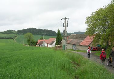
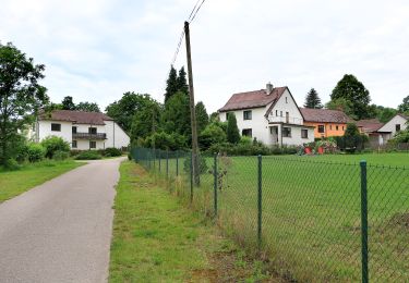
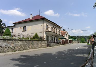
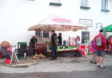
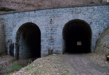
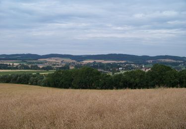
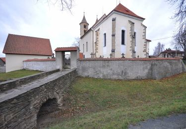
Tour Zu Fuß von 8,6 km verfügbar auf Mittelböhmen, Unbekannt, Postupice. Diese Tour wird von SityTrail - itinéraires balisés pédestres vorgeschlagen.
Beschreibung
Tour erstellt von cz:KČT.
Ort
Land:
Czech Republic
Region :
Mittelböhmen
Abteilung/Provinz :
Unbekannt
Kommune :
Postupice
Standort:
Unknown
Gehen Sie:(Dec)
Gehen Sie:(UTM)
484323 ; 5509533 (33U) N.
Kommentare
Touren in der Umgebung
![Tour Zu Fuß Wotitz - NS Kolem Votic za poznáním - Photo](https://media.geolcdn.com/t/375/260/f108630b-d984-4854-ab21-829e31ac2ddd.jpeg&format=jpg&maxdim=2)
![Zu Fuß Zu Fuß](https://static1.geolcdn.com/sitytour/trail-icons/100.png)
NS Kolem Votic za poznáním
Zu Fuß
Einfach
Wotitz,
Mittelböhmen,
Unbekannt,
Czech Republic
![](/images/other/stat-length.png)
8,5 km | 12,2 km-effort
2h 46min
![](https://static1.geolcdn.com/siteimages/upload/files/16400158638029165_repeat_loop_refresh_sync_direction_icon.png)
Ja
![Tour Zu Fuß Jankow - NS Po stopách bitvy u Jankova - Photo](https://media.geolcdn.com/t/375/260/fe4031eb-dcc3-4eed-9f5a-ddfe5ac821b0.jpeg&format=jpg&maxdim=2)
![Zu Fuß Zu Fuß](https://static1.geolcdn.com/sitytour/trail-icons/100.png)
NS Po stopách bitvy u Jankova
Zu Fuß
Einfach
Jankow,
Mittelböhmen,
Unbekannt,
Czech Republic
![](/images/other/stat-length.png)
6,3 km | 8,1 km-effort
1h 49min
![](https://static1.geolcdn.com/siteimages/upload/files/16400158638029165_repeat_loop_refresh_sync_direction_icon.png)
Nein
![Tour Zu Fuß Krehanitz - NS Podlešanský mlýn - Photo](https://media.geolcdn.com/t/375/260/522b6618-3dd2-4ca7-9890-82d009c8a7f8.jpeg&format=jpg&maxdim=2)
![Zu Fuß Zu Fuß](https://static1.geolcdn.com/sitytour/trail-icons/100.png)
NS Podlešanský mlýn
Zu Fuß
Einfach
Krehanitz,
Mittelböhmen,
Unbekannt,
Czech Republic
![](/images/other/stat-length.png)
5 km | 6,2 km-effort
1h 24min
![](https://static1.geolcdn.com/siteimages/upload/files/16400158638029165_repeat_loop_refresh_sync_direction_icon.png)
Nein
![Tour Zu Fuß Olbramovice - NS Po stopách Sidonie Nádherné - Photo](https://media.geolcdn.com/t/375/260/d6a401c2-a3e3-42a7-8ff6-5aeee2587c93.jpeg&format=jpg&maxdim=2)
![Zu Fuß Zu Fuß](https://static1.geolcdn.com/sitytour/trail-icons/100.png)
NS Po stopách Sidonie Nádherné
Zu Fuß
Einfach
Olbramovice,
Mittelböhmen,
Unbekannt,
Czech Republic
![](/images/other/stat-length.png)
5,8 km | 6,8 km-effort
1h 32min
![](https://static1.geolcdn.com/siteimages/upload/files/16400158638029165_repeat_loop_refresh_sync_direction_icon.png)
Nein
![Tour Zu Fuß Senochrab - NS Vodnické vycházky - Photo](https://media.geolcdn.com/t/375/260/fedbc7dd-c2ce-468c-a163-85e31b3912b2.jpeg&format=jpg&maxdim=2)
![Zu Fuß Zu Fuß](https://static1.geolcdn.com/sitytour/trail-icons/100.png)
NS Vodnické vycházky
Zu Fuß
Einfach
Senochrab,
Mittelböhmen,
Unbekannt,
Czech Republic
![](/images/other/stat-length.png)
3,1 km | 4,5 km-effort
1h 1min
![](https://static1.geolcdn.com/siteimages/upload/files/16400158638029165_repeat_loop_refresh_sync_direction_icon.png)
Nein
![Tour Zu Fuß Beneschau - [Č] Konopiště, okružní trasa - Photo](https://media.geolcdn.com/t/375/260/eef819f5-eaef-45e1-82ea-e15eb10f81b9.jpeg&format=jpg&maxdim=2)
![Zu Fuß Zu Fuß](https://static1.geolcdn.com/sitytour/trail-icons/100.png)
[Č] Konopiště, okružní trasa
Zu Fuß
Einfach
Beneschau,
Mittelböhmen,
Unbekannt,
Czech Republic
![](/images/other/stat-length.png)
5,3 km | 6,9 km-effort
1h 34min
![](https://static1.geolcdn.com/siteimages/upload/files/16400158638029165_repeat_loop_refresh_sync_direction_icon.png)
Ja
![Tour Zu Fuß Sedletz-Pertschitz - NS Od Vítkovské růže k zázračnému prameni - Photo](https://media.geolcdn.com/t/375/260/b72fcd34-8b1f-4eab-a4fb-be1234dc7033.jpeg&format=jpg&maxdim=2)
![Zu Fuß Zu Fuß](https://static1.geolcdn.com/sitytour/trail-icons/100.png)
NS Od Vítkovské růže k zázračnému prameni
Zu Fuß
Einfach
Sedletz-Pertschitz,
Mittelböhmen,
Unbekannt,
Czech Republic
![](/images/other/stat-length.png)
6,9 km | 8 km-effort
1h 48min
![](https://static1.geolcdn.com/siteimages/upload/files/16400158638029165_repeat_loop_refresh_sync_direction_icon.png)
Ja
![Tour Zu Fuß Kondrac - NS S rytířem na Blaník - Photo](https://media.geolcdn.com/t/375/260/435c9133-6f34-4a0b-bc1f-a004f98d7294.jpeg&format=jpg&maxdim=2)
![Zu Fuß Zu Fuß](https://static1.geolcdn.com/sitytour/trail-icons/100.png)
NS S rytířem na Blaník
Zu Fuß
Einfach
Kondrac,
Mittelböhmen,
Unbekannt,
Czech Republic
![](/images/other/stat-length.png)
3,5 km | 6,1 km-effort
1h 23min
![](https://static1.geolcdn.com/siteimages/upload/files/16400158638029165_repeat_loop_refresh_sync_direction_icon.png)
Nein
![Tour Zu Fuß Načeradec - [Ž] Načeradec - Dolní Královice - Photo](https://media.geolcdn.com/t/375/260/abc587a4-d8ff-40b4-bfd6-900f9bef250f.jpeg&format=jpg&maxdim=2)
![Zu Fuß Zu Fuß](https://static1.geolcdn.com/sitytour/trail-icons/100.png)
[Ž] Načeradec - Dolní Královice
Zu Fuß
Schwierig
Načeradec,
Mittelböhmen,
Unbekannt,
Czech Republic
![](/images/other/stat-length.png)
26 km | 33 km-effort
7h 28min
![](https://static1.geolcdn.com/siteimages/upload/files/16400158638029165_repeat_loop_refresh_sync_direction_icon.png)
Nein