![](/images/other/stat-length.png)
![Tour Zu Fuß Trnau - NS Jíloviště - Cukrák - Photo](https://media.geolcdn.com/t/1900/400/b4c50bf3-118e-42f6-aafb-28d2d3bc79a4.jpeg&format=pjpeg&maxdim=2)
NS Jíloviště - Cukrák
SityTrail - itinéraires balisés pédestres
Tous les sentiers balisés d’Europe GUIDE+
![Länge](/images/other/stat-length.png)
Länge
4,4 km
![Maximale Höhe](https://static1.geolcdn.com/siteimages/upload/files/1508320355ic_sort_altitude_max_24dp.png)
Maximale Höhe
403 m
![Positive Höhendifferenz](https://static1.geolcdn.com/siteimages/upload/files/1508320355ic_sort_den_pos_24dp.png)
Positive Höhendifferenz
196 m
![Km-Effort](/images/other/stat-length.png)
Km-Effort
6,6 km
![Min. Höhe](https://static1.geolcdn.com/siteimages/upload/files/1508320355ic_sort_altitude_min_24dp.png)
Min. Höhe
221 m
![Negative Höhendifferenz](https://static1.geolcdn.com/siteimages/upload/files/1508320355ic_sort_den_neg_24dp.png)
Negative Höhendifferenz
67 m
![Boucle](https://static1.geolcdn.com/siteimages/upload/files/16400158638029165_repeat_loop_refresh_sync_direction_icon.png)
Boucle
Nein
Kennzeichnung
Erstellungsdatum :
2025-02-06 20:43:28.618
Letzte Änderung :
2025-02-06 20:43:28.618
![Zu Fuß](https://static1.geolcdn.com/sitytour/trail-icons/100.png)
1h30
Schwierigkeit : Einfach
![Scannen Sie diesen QR-Code, um die Tour in der SityTrail-Anwendung zu öffnen](https://capi.geolives.com/qq0zvz2zws4bq2lad0pu/sitytour/trails/4344058/qr.png?size=200)
Kostenlosegpshiking-Anwendung
Über SityTrail
Tour Zu Fuß von 4,4 km verfügbar auf Mittelböhmen, Unbekannt, Trnau. Diese Tour wird von SityTrail - itinéraires balisés pédestres vorgeschlagen.
Beschreibung
Tour erstellt von local.
jíloviště;cukrák;?
Ort
Land:
Czech Republic
Region :
Mittelböhmen
Abteilung/Provinz :
Unbekannt
Kommune :
Trnau
Standort:
Unknown
Gehen Sie:(Dec)
Gehen Sie:(UTM)
454762 ; 5530442 (33U) N.
Kommentare
Touren in der Umgebung
![Tour Zu Fuß Tschernolitz - NS Putování Černolickem - Photo](https://media.geolcdn.com/t/375/260/3d6ca1f7-5098-486f-a0ff-96334a205635.jpeg&format=jpg&maxdim=2)
![Zu Fuß Zu Fuß](https://static1.geolcdn.com/sitytour/trail-icons/100.png)
NS Putování Černolickem
Zu Fuß
Einfach
Tschernolitz,
Mittelböhmen,
Unbekannt,
Czech Republic
![](/images/other/stat-length.png)
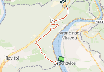
4,2 km | 6 km-effort
1h 21min
![](https://static1.geolcdn.com/siteimages/upload/files/16400158638029165_repeat_loop_refresh_sync_direction_icon.png)
Ja
![Tour Zu Fuß Miechenitz - [M] Měchenice - Všenory - Photo](https://media.geolcdn.com/t/375/260/06630537-e029-451b-a301-b274a78a918c.jpeg&format=jpg&maxdim=2)
![Zu Fuß Zu Fuß](https://static1.geolcdn.com/sitytour/trail-icons/100.png)
[M] Měchenice - Všenory
Zu Fuß
Einfach
Miechenitz,
Mittelböhmen,
Unbekannt,
Czech Republic
![](/images/other/stat-length.png)
8,2 km | 11,1 km-effort
2h 31min
![](https://static1.geolcdn.com/siteimages/upload/files/16400158638029165_repeat_loop_refresh_sync_direction_icon.png)
Nein
![Tour Zu Fuß Jilowischt - [Z] Jíloviště - Všenory - Photo](https://media.geolcdn.com/t/375/260/06630537-e029-451b-a301-b274a78a918c.jpeg&format=jpg&maxdim=2)
![Zu Fuß Zu Fuß](https://static1.geolcdn.com/sitytour/trail-icons/100.png)
[Z] Jíloviště - Všenory
Zu Fuß
Einfach
Jilowischt,
Mittelböhmen,
Unbekannt,
Czech Republic
![](/images/other/stat-length.png)
4,1 km | 5,5 km-effort
1h 14min
![](https://static1.geolcdn.com/siteimages/upload/files/16400158638029165_repeat_loop_refresh_sync_direction_icon.png)
Nein
![Tour Zu Fuß Jilowischt - [Ž] Jíloviště - Černošice - Photo](https://media.geolcdn.com/t/375/260/658263c1-3fcf-44eb-9c17-2cb3a74b2689.jpeg&format=jpg&maxdim=2)
![Zu Fuß Zu Fuß](https://static1.geolcdn.com/sitytour/trail-icons/100.png)
[Ž] Jíloviště - Černošice
Zu Fuß
Einfach
Jilowischt,
Mittelböhmen,
Unbekannt,
Czech Republic
![](/images/other/stat-length.png)
6,3 km | 7,9 km-effort
1h 48min
![](https://static1.geolcdn.com/siteimages/upload/files/16400158638029165_repeat_loop_refresh_sync_direction_icon.png)
Nein
![Tour Zu Fuß Bschesowa - [Ž] Na Dolech-Psáry - Photo](https://media.geolcdn.com/t/375/260/5eaa306a-6bcd-49ff-9f66-a7c38f811023.jpeg&format=jpg&maxdim=2)
![Zu Fuß Zu Fuß](https://static1.geolcdn.com/sitytour/trail-icons/100.png)
[Ž] Na Dolech-Psáry
Zu Fuß
Einfach
Bschesowa,
Mittelböhmen,
Unbekannt,
Czech Republic
![](/images/other/stat-length.png)
10,3 km | 13 km-effort
2h 57min
![](https://static1.geolcdn.com/siteimages/upload/files/16400158638029165_repeat_loop_refresh_sync_direction_icon.png)
Nein
![Tour Zu Fuß Swoll - [Ž] Vrané - Ohrobská - Photo](https://media.geolcdn.com/t/375/260/2b998145-2f51-4216-98cc-0d1c0929ad72.jpeg&format=jpg&maxdim=2)
![Zu Fuß Zu Fuß](https://static1.geolcdn.com/sitytour/trail-icons/100.png)
[Ž] Vrané - Ohrobská
Zu Fuß
Einfach
Swoll,
Mittelböhmen,
Unbekannt,
Czech Republic
![](/images/other/stat-length.png)
4,2 km | 4,9 km-effort
1h 7min
![](https://static1.geolcdn.com/siteimages/upload/files/16400158638029165_repeat_loop_refresh_sync_direction_icon.png)
Nein
![Tour Zu Fuß Dawle - [Ž] Davle - Jílové u P. - Photo](https://media.geolcdn.com/t/375/260/565e6ba4-c226-4a61-be53-789e63a62320.jpeg&format=jpg&maxdim=2)
![Zu Fuß Zu Fuß](https://static1.geolcdn.com/sitytour/trail-icons/100.png)
[Ž] Davle - Jílové u P.
Zu Fuß
Einfach
Dawle,
Mittelböhmen,
Unbekannt,
Czech Republic
![](/images/other/stat-length.png)
10,8 km | 14,9 km-effort
3h 22min
![](https://static1.geolcdn.com/siteimages/upload/files/16400158638029165_repeat_loop_refresh_sync_direction_icon.png)
Nein
![Tour Zu Fuß Tschisowitz - [Z] Bojov-Davle - Photo](https://media.geolcdn.com/t/375/260/0a1d902c-ad6e-40f3-ac52-7211c51fb088.jpeg&format=jpg&maxdim=2)
![Zu Fuß Zu Fuß](https://static1.geolcdn.com/sitytour/trail-icons/100.png)
[Z] Bojov-Davle
Zu Fuß
Einfach
Tschisowitz,
Mittelböhmen,
Unbekannt,
Czech Republic
![](/images/other/stat-length.png)
5 km | 6,4 km-effort
1h 27min
![](https://static1.geolcdn.com/siteimages/upload/files/16400158638029165_repeat_loop_refresh_sync_direction_icon.png)
Nein
![Tour Zu Fuß Cernositz - [M] Černošice - Dub sedmi bratří - Photo](https://media.geolcdn.com/t/375/260/b3245b35-2206-4973-a671-0f64caf56378.jpeg&format=jpg&maxdim=2)
![Zu Fuß Zu Fuß](https://static1.geolcdn.com/sitytour/trail-icons/100.png)
[M] Černošice - Dub sedmi bratří
Zu Fuß
Einfach
Cernositz,
Mittelböhmen,
Unbekannt,
Czech Republic
![](/images/other/stat-length.png)
11,8 km | 16 km-effort
3h 37min
![](https://static1.geolcdn.com/siteimages/upload/files/16400158638029165_repeat_loop_refresh_sync_direction_icon.png)
Nein