


8,3 km | 10,7 km-effort
![Tour Zu Fuß Engelsberg - [Ž] Ovčárna - Brantice - Photo](https://media.geolcdn.com/t/1900/400/56802721-ae92-4609-a4ba-e69adace9f31.jpeg&format=pjpeg&maxdim=2)

Tous les sentiers balisés d’Europe GUIDE+


Kostenlosegpshiking-Anwendung
 SityTrail
IGN / Geografische Institute
SityTrail World
Die Welt öffnet sich für Sie
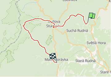
Tour Zu Fuß von 23 km verfügbar auf Mährisch-Schlesien, Mährisch-Schlesische Region, Engelsberg. Diese Tour wird von SityTrail - itinéraires balisés pédestres vorgeschlagen.
Tour erstellt von cz:KČT.
![Tour Zu Fuß Engelsberg - [Ž] Ovčárna - Brantice - Photo 1](https://media.geolcdn.com/t/2048/auto/f42836f1-fac9-4781-8615-13af5d0daca7.jpeg&format=jpg&maxdim=0 "Tour Zu Fuß Engelsberg - [Ž] Ovčárna - Brantice - Photo 1")
![Tour Zu Fuß Engelsberg - [Ž] Ovčárna - Brantice - Photo 2](https://media.geolcdn.com/t/2048/auto/09036e7d-00d8-4c99-8dfb-55fcde90da09.jpeg&format=jpg&maxdim=0 "Tour Zu Fuß Engelsberg - [Ž] Ovčárna - Brantice - Photo 2")
![Tour Zu Fuß Engelsberg - [Ž] Ovčárna - Brantice - Photo 3](https://media.geolcdn.com/t/2048/auto/fc42d528-6001-45ba-be52-11a89ea88fbd.jpeg&format=jpg&maxdim=0 "Tour Zu Fuß Engelsberg - [Ž] Ovčárna - Brantice - Photo 3")
![Tour Zu Fuß Engelsberg - [Ž] Ovčárna - Brantice - Photo 4](https://media.geolcdn.com/t/2048/auto/34b1cfb1-1acb-4e9d-9bb1-d1fec02132ee.jpeg&format=jpg&maxdim=0 "Tour Zu Fuß Engelsberg - [Ž] Ovčárna - Brantice - Photo 4")
![Tour Zu Fuß Engelsberg - [Ž] Ovčárna - Brantice - Photo 5](https://media.geolcdn.com/t/2048/auto/cb6af40d-e296-439b-933c-417a49b3c1d1.jpeg&format=jpg&maxdim=0 "Tour Zu Fuß Engelsberg - [Ž] Ovčárna - Brantice - Photo 5")
![Tour Zu Fuß Engelsberg - [Ž] Ovčárna - Brantice - Photo 6](https://media.geolcdn.com/t/2048/auto/5555d37b-3ee6-4e5e-a3f1-3e3c75dc251f.jpeg&format=jpg&maxdim=0 "Tour Zu Fuß Engelsberg - [Ž] Ovčárna - Brantice - Photo 6")
![Tour Zu Fuß Engelsberg - [Ž] Ovčárna - Brantice - Photo 7](https://media.geolcdn.com/t/2048/auto/50a9815d-34d7-4641-a70e-056fd5517a26.jpeg&format=jpg&maxdim=0 "Tour Zu Fuß Engelsberg - [Ž] Ovčárna - Brantice - Photo 7")
![Tour Zu Fuß Engelsberg - [Ž] Ovčárna - Brantice - Photo 8](https://media.geolcdn.com/t/2048/auto/8f1218a2-f146-49a7-b15e-990a73a615d8.jpeg&format=jpg&maxdim=0 "Tour Zu Fuß Engelsberg - [Ž] Ovčárna - Brantice - Photo 8")
![Tour Zu Fuß Engelsberg - [Ž] Ovčárna - Brantice - Photo 9](https://media.geolcdn.com/t/2048/auto/56802721-ae92-4609-a4ba-e69adace9f31.jpeg&format=jpg&maxdim=0 "Tour Zu Fuß Engelsberg - [Ž] Ovčárna - Brantice - Photo 9")
![Tour Zu Fuß Engelsberg - [Ž] Ovčárna - Brantice - Photo 10](https://media.geolcdn.com/t/2048/auto/5c29a5a5-0f85-41bd-aba3-362902d5eee2.jpeg&format=jpg&maxdim=0 "Tour Zu Fuß Engelsberg - [Ž] Ovčárna - Brantice - Photo 10")
![Tour Zu Fuß Karlsbrunn - [Č] Malá Morávka - Karlova Studánka - Photo](https://media.geolcdn.com/t/375/260/81acd68f-f183-4dc5-8d51-dbab62c604d5.jpeg&format=jpg&maxdim=2)
Zu Fuß
![Tour Zu Fuß Jägerndorf - [Č] okruh kolem Krnova - Photo](https://media.geolcdn.com/t/375/260/0c9d8cbf-3608-4e3b-bb39-83d0370a4b42.jpeg&format=jpg&maxdim=2)
Zu Fuß
Zu Fuß
![Tour Zu Fuß Milkendorf - [M] Milotice nad Opavou - Krnov - Photo](https://media.geolcdn.com/t/375/260/8e7566ad-25ee-42af-96bf-113d9a2183cc.jpeg&format=jpg&maxdim=2)
Zu Fuß
![Tour Zu Fuß Olbersdorf - [Ž] Albrechtice - Petrovy boudy - Photo](https://media.geolcdn.com/t/375/260/f4747928-09d6-4159-b288-1d744968c1cc.jpeg&format=jpg&maxdim=2)
Zu Fuß
![Tour Zu Fuß Nieder Lindewiese - [Č] Lázně Lipová - Dolní Lipová - Photo](https://media.geolcdn.com/t/375/260/89666500-85c0-4bea-897f-f89baf646252.jpeg&format=jpg&maxdim=2)
Zu Fuß
Zu Fuß
![Tour Zu Fuß Nieder Lindewiese - [Z] Ramzová - Obří skály - Photo](https://media.geolcdn.com/t/375/260/2e4c1233-6967-40e1-b71d-3baad939719d.jpeg&format=jpg&maxdim=2)
Zu Fuß
![Tour Zu Fuß Wermsdorf - [M] U Františkovy myslivny - Kosaře - Photo](https://media.geolcdn.com/t/375/260/43aa4f93-e934-4aa4-a34b-03b734430cad.jpeg&format=jpg&maxdim=2)
Zu Fuß