


13,9 km | 17,9 km-effort
![Tour Zu Fuß Kladruby nad Labem - [Č] Kladruby - Přelouč - Photo](https://media.geolcdn.com/t/1900/400/f96fe7b0-7312-4d06-9975-7d9efd906da9.jpeg&format=pjpeg&maxdim=2)

Tous les sentiers balisés d’Europe GUIDE+


Kostenlosegpshiking-Anwendung
 SityTrail
IGN / Geografische Institute
SityTrail World
Die Welt öffnet sich für Sie
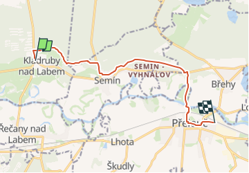
Tour Zu Fuß von 9,8 km verfügbar auf Nordosten, Pardubitzer Region, Kladruby nad Labem. Diese Tour wird von SityTrail - itinéraires balisés pédestres vorgeschlagen.
Tour erstellt von cz:KČT.
![Tour Zu Fuß Kladruby nad Labem - [Č] Kladruby - Přelouč - Photo 1](https://media.geolcdn.com/t/2048/auto/76b6b747-dd7a-49ed-bd84-35a99245bd03.jpeg&format=jpg&maxdim=0 "Tour Zu Fuß Kladruby nad Labem - [Č] Kladruby - Přelouč - Photo 1")
![Tour Zu Fuß Kladruby nad Labem - [Č] Kladruby - Přelouč - Photo 2](https://media.geolcdn.com/t/2048/auto/9425069a-6c73-4f88-a86b-616e1deb08be.jpeg&format=jpg&maxdim=0 "Tour Zu Fuß Kladruby nad Labem - [Č] Kladruby - Přelouč - Photo 2")
![Tour Zu Fuß Kladruby nad Labem - [Č] Kladruby - Přelouč - Photo 3](https://media.geolcdn.com/t/2048/auto/d93bc890-9664-4a85-9734-b8e6372f0f4c.jpeg&format=jpg&maxdim=0 "Tour Zu Fuß Kladruby nad Labem - [Č] Kladruby - Přelouč - Photo 3")
![Tour Zu Fuß Kladruby nad Labem - [Č] Kladruby - Přelouč - Photo 4](https://media.geolcdn.com/t/2048/auto/07c61952-eb52-4cd5-ba59-fdc75173ffda.jpeg&format=jpg&maxdim=0 "Tour Zu Fuß Kladruby nad Labem - [Č] Kladruby - Přelouč - Photo 4")
![Tour Zu Fuß Kladruby nad Labem - [Č] Kladruby - Přelouč - Photo 5](https://media.geolcdn.com/t/2048/auto/441ff76f-ccc7-473d-9c37-741ab50768be.jpeg&format=jpg&maxdim=0 "Tour Zu Fuß Kladruby nad Labem - [Č] Kladruby - Přelouč - Photo 5")
![Tour Zu Fuß Kladruby nad Labem - [Č] Kladruby - Přelouč - Photo 6](https://media.geolcdn.com/t/2048/auto/26f6c353-8eff-4d35-a809-1c51bd979c92.jpeg&format=jpg&maxdim=0 "Tour Zu Fuß Kladruby nad Labem - [Č] Kladruby - Přelouč - Photo 6")
![Tour Zu Fuß Kladruby nad Labem - [Č] Kladruby - Přelouč - Photo 7](https://media.geolcdn.com/t/2048/auto/281eb482-b36b-4fb0-a397-b585d050f8b1.jpeg&format=jpg&maxdim=0 "Tour Zu Fuß Kladruby nad Labem - [Č] Kladruby - Přelouč - Photo 7")
![Tour Zu Fuß Kladruby nad Labem - [Č] Kladruby - Přelouč - Photo 8](https://media.geolcdn.com/t/2048/auto/dd38d595-fcc3-4d71-9438-5d21a733d84d.jpeg&format=jpg&maxdim=0 "Tour Zu Fuß Kladruby nad Labem - [Č] Kladruby - Přelouč - Photo 8")
![Tour Zu Fuß Kladruby nad Labem - [Č] Kladruby - Přelouč - Photo 9](https://media.geolcdn.com/t/2048/auto/2e2e34ff-3bae-4bcd-9b57-a01406bd20d3.jpeg&format=jpg&maxdim=0 "Tour Zu Fuß Kladruby nad Labem - [Č] Kladruby - Přelouč - Photo 9")
![Tour Zu Fuß Kladruby nad Labem - [Č] Kladruby - Přelouč - Photo 10](https://media.geolcdn.com/t/2048/auto/f96fe7b0-7312-4d06-9975-7d9efd906da9.jpeg&format=jpg&maxdim=0 "Tour Zu Fuß Kladruby nad Labem - [Č] Kladruby - Přelouč - Photo 10")
![Tour Zu Fuß Semtěš - [Ž] Konopáč - Semtěš - Photo](https://media.geolcdn.com/t/375/260/4b4cb51a-3f87-4840-8d60-7e3ab3cd869f.jpeg&format=jpg&maxdim=2)
Zu Fuß
![Tour Zu Fuß Tschaslau - [Z] Čáslav - Pod Tisou skálou - Photo](https://media.geolcdn.com/t/375/260/946bc21c-d4b8-4dc3-b551-c6568a399953.jpeg&format=jpg&maxdim=2)
Zu Fuß
![Tour Zu Fuß Kolin - [Ž] Kolín - Záboří nad Labem - Photo](https://media.geolcdn.com/t/375/260/c0f493d3-ec7c-413b-84d0-7134f36f4e1f.jpeg&format=jpg&maxdim=2)
Zu Fuß
![Tour Zu Fuß Rabštejnská Lhota - [Ž] Chrudim - Podhůra - Rabštejnská Lhota - Photo](https://media.geolcdn.com/t/375/260/a13872a9-b837-4337-b291-a43ad8f7a8bb.jpeg&format=jpg&maxdim=2)
Zu Fuß
![Tour Zu Fuß Vápenný Podol - [Z] Vápenný Podol - Lovětínská rokle - Photo](https://media.geolcdn.com/t/375/260/ed4a2dcc-90b9-41d4-a6f1-952f7b0de326.jpeg&format=jpg&maxdim=2)
Zu Fuß
![Tour Zu Fuß Chlístovice - [M] Kutná Hora - Sion - Photo](https://media.geolcdn.com/t/375/260/f7bd726a-99e7-4337-aabf-16f555628678.jpeg&format=jpg&maxdim=2)
Zu Fuß
Zu Fuß
![Tour Zu Fuß Zdechovice - [Ž] Morašice - Svojšice - Photo](https://media.geolcdn.com/t/375/260/f143d729-598a-40d2-b273-3cfaab803058.jpeg&format=jpg&maxdim=2)
Zu Fuß
![Tour Zu Fuß Valy - [Č] Heřmanův Městec - Lepějovice - Photo](https://media.geolcdn.com/t/375/260/54f32eee-5fd1-4854-b492-42524c595dd4.jpeg&format=jpg&maxdim=2)
Zu Fuß