


10,7 km | 14,1 km-effort
![Tour Zu Fuß Dawle - [Ž] Davle - Jílové u P. - Photo](https://media.geolcdn.com/t/1900/400/565e6ba4-c226-4a61-be53-789e63a62320.jpeg&format=pjpeg&maxdim=2)

Tous les sentiers balisés d’Europe GUIDE+


Kostenlosegpshiking-Anwendung
 SityTrail
IGN / Geografische Institute
SityTrail World
Die Welt öffnet sich für Sie
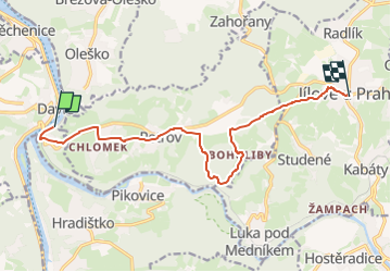
Tour Zu Fuß von 10,8 km verfügbar auf Mittelböhmen, Unbekannt, Dawle. Diese Tour wird von SityTrail - itinéraires balisés pédestres vorgeschlagen.
Tour erstellt von cz:KČT.
![Tour Zu Fuß Dawle - [Ž] Davle - Jílové u P. - Photo 1](https://media.geolcdn.com/t/2048/auto/f6968670-c94c-48d8-9978-735f8174a553.jpeg&format=jpg&maxdim=0 "Tour Zu Fuß Dawle - [Ž] Davle - Jílové u P. - Photo 1")
![Tour Zu Fuß Dawle - [Ž] Davle - Jílové u P. - Photo 2](https://media.geolcdn.com/t/2048/auto/6872ac25-2a2c-44f9-a83f-b22b78d89563.jpeg&format=jpg&maxdim=0 "Tour Zu Fuß Dawle - [Ž] Davle - Jílové u P. - Photo 2")
![Tour Zu Fuß Dawle - [Ž] Davle - Jílové u P. - Photo 3](https://media.geolcdn.com/t/2048/auto/bed0951f-5a4d-4eae-b0db-b14aa5e6d431.jpeg&format=jpg&maxdim=0 "Tour Zu Fuß Dawle - [Ž] Davle - Jílové u P. - Photo 3")
![Tour Zu Fuß Dawle - [Ž] Davle - Jílové u P. - Photo 4](https://media.geolcdn.com/t/2048/auto/6a66f9ec-e494-4a04-a7fe-d74e480863f3.jpeg&format=jpg&maxdim=0 "Tour Zu Fuß Dawle - [Ž] Davle - Jílové u P. - Photo 4")
![Tour Zu Fuß Dawle - [Ž] Davle - Jílové u P. - Photo 5](https://media.geolcdn.com/t/2048/auto/ccd6680e-bd04-4863-a9fa-13b996c74785.jpeg&format=jpg&maxdim=0 "Tour Zu Fuß Dawle - [Ž] Davle - Jílové u P. - Photo 5")
![Tour Zu Fuß Dawle - [Ž] Davle - Jílové u P. - Photo 6](https://media.geolcdn.com/t/2048/auto/ea5a9c8f-4e28-4dea-88b4-de0d6d85fce1.jpeg&format=jpg&maxdim=0 "Tour Zu Fuß Dawle - [Ž] Davle - Jílové u P. - Photo 6")
![Tour Zu Fuß Dawle - [Ž] Davle - Jílové u P. - Photo 7](https://media.geolcdn.com/t/2048/auto/3b733af8-a8e6-4205-ad88-c264515e004c.jpeg&format=jpg&maxdim=0 "Tour Zu Fuß Dawle - [Ž] Davle - Jílové u P. - Photo 7")
![Tour Zu Fuß Dawle - [Ž] Davle - Jílové u P. - Photo 8](https://media.geolcdn.com/t/2048/auto/7ccddace-9fa5-4ba0-a24c-308fe12fc25d.jpeg&format=jpg&maxdim=0 "Tour Zu Fuß Dawle - [Ž] Davle - Jílové u P. - Photo 8")
![Tour Zu Fuß Dawle - [Ž] Davle - Jílové u P. - Photo 9](https://media.geolcdn.com/t/2048/auto/565e6ba4-c226-4a61-be53-789e63a62320.jpeg&format=jpg&maxdim=0 "Tour Zu Fuß Dawle - [Ž] Davle - Jílové u P. - Photo 9")
![Tour Zu Fuß Dawle - [Ž] Davle - Jílové u P. - Photo 10](https://media.geolcdn.com/t/2048/auto/541524b6-3704-488a-bb8a-99430638a52f.jpeg&format=jpg&maxdim=0 "Tour Zu Fuß Dawle - [Ž] Davle - Jílové u P. - Photo 10")

Motorboot
![Tour Zu Fuß Bojanowitz - [Z] Štěchovice - Nový Knín - Photo](https://media.geolcdn.com/t/375/260/3abfdc1c-a054-4737-a058-bae860c04258.jpeg&format=jpg&maxdim=2)
Zu Fuß
![Tour Zu Fuß Tschisowitz - [M] Bojanovice-Slapy - Photo](https://media.geolcdn.com/t/375/260/06ccaf2e-01ad-4e7d-9e04-62528bef7565.jpeg&format=jpg&maxdim=2)
Zu Fuß
![Tour Zu Fuß Miechenitz - [M] Měchenice - Všenory - Photo](https://media.geolcdn.com/t/375/260/06630537-e029-451b-a301-b274a78a918c.jpeg&format=jpg&maxdim=2)
Zu Fuß
Zu Fuß
Zu Fuß
![Tour Zu Fuß Petrow - [Č] Jílovské vyhlídky - okruh - Photo](https://media.geolcdn.com/t/375/260/79529de6-ead8-47c9-94dd-a6d50a4da4ed.jpeg&format=jpg&maxdim=2)
Zu Fuß
![Tour Zu Fuß Krinian - [Z] Pikovice - Pod Třebsínem - Photo](https://media.geolcdn.com/t/375/260/9d973daa-efdc-425c-b30b-77795e7c71fa.jpeg&format=jpg&maxdim=2)
Zu Fuß
![Tour Zu Fuß Stiechowitz - [Z] Pod Homolí - Třebenice - Photo](https://media.geolcdn.com/t/375/260/f74490da-eba5-420f-ba19-f5f256693f47.jpeg&format=jpg&maxdim=2)
Zu Fuß