![](/images/other/stat-length.png)
![Tour Zu Fuß Außergefild - NS Nelesní krajina - Photo](https://media.geolcdn.com/t/1900/400/183df208-21a6-4425-9170-2bdde71cfec8.jpeg&format=pjpeg&maxdim=2)
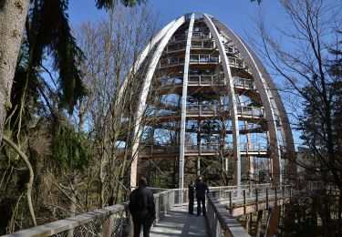
NS Nelesní krajina
SityTrail - itinéraires balisés pédestres
Tous les sentiers balisés d’Europe GUIDE+
![Länge](/images/other/stat-length.png)
Länge
6 km
![Maximale Höhe](https://static1.geolcdn.com/siteimages/upload/files/1508320355ic_sort_altitude_max_24dp.png)
Maximale Höhe
1149 m
![Positive Höhendifferenz](https://static1.geolcdn.com/siteimages/upload/files/1508320355ic_sort_den_pos_24dp.png)
Positive Höhendifferenz
181 m
![Km-Effort](/images/other/stat-length.png)
Km-Effort
8,4 km
![Min. Höhe](https://static1.geolcdn.com/siteimages/upload/files/1508320355ic_sort_altitude_min_24dp.png)
Min. Höhe
1031 m
![Negative Höhendifferenz](https://static1.geolcdn.com/siteimages/upload/files/1508320355ic_sort_den_neg_24dp.png)
Negative Höhendifferenz
185 m
![Boucle](https://static1.geolcdn.com/siteimages/upload/files/16400158638029165_repeat_loop_refresh_sync_direction_icon.png)
Boucle
Ja
Kennzeichnung
Erstellungsdatum :
2025-02-06 16:39:22.776
Letzte Änderung :
2025-02-06 16:39:22.776
![Zu Fuß](https://static1.geolcdn.com/sitytour/trail-icons/100.png)
1h54
Schwierigkeit : Einfach
![Scannen Sie diesen QR-Code, um die Tour in der SityTrail-Anwendung zu öffnen](https://capi.geolives.com/qq0zvz2zws4bq2lad0pu/sitytour/trails/4343631/qr.png?size=200)
Kostenlosegpshiking-Anwendung
Über SityTrail
Tour Zu Fuß von 6 km verfügbar auf Südwesten, Südböhmische Region, Außergefild. Diese Tour wird von SityTrail - itinéraires balisés pédestres vorgeschlagen.
Beschreibung
Tour erstellt von cz:KČT.
Ort
Land:
Czech Republic
Region :
Südwesten
Abteilung/Provinz :
Südböhmische Region
Kommune :
Außergefild
Standort:
Unknown
Gehen Sie:(Dec)
Gehen Sie:(UTM)
396012 ; 5429831 (33U) N.
Kommentare
Touren in der Umgebung
![Tour Zu Fuß Neuschönau - Dachs - Photo](https://media.geolcdn.com/t/375/260/bd4d4b66-a4a1-483f-a98d-2833317cd1dc.jpeg&format=jpg&maxdim=2)
![Zu Fuß Zu Fuß](https://static1.geolcdn.com/sitytour/trail-icons/100.png)
Dachs
Zu Fuß
Einfach
Neuschönau,
Bayern,
Landkreis Freyung-Grafenau,
Germany
![](/images/other/stat-length.png)
4,5 km | 5,7 km-effort
1h 17min
![](https://static1.geolcdn.com/siteimages/upload/files/16400158638029165_repeat_loop_refresh_sync_direction_icon.png)
Ja
![Tour Zu Fuß Neuschönau - Haustaube - Photo](https://media.geolcdn.com/t/375/260/78aeb269-300f-4d79-aaf4-32920732cb70.jpeg&format=jpg&maxdim=2)
![Zu Fuß Zu Fuß](https://static1.geolcdn.com/sitytour/trail-icons/100.png)
Haustaube
Zu Fuß
Einfach
Neuschönau,
Bayern,
Landkreis Freyung-Grafenau,
Germany
![](/images/other/stat-length.png)
6,8 km | 9,5 km-effort
2h 8min
![](https://static1.geolcdn.com/siteimages/upload/files/16400158638029165_repeat_loop_refresh_sync_direction_icon.png)
Ja
![Tour Zu Fuß Grafenau - Bärenpfad - Photo](https://media.geolcdn.com/t/375/260/5eafdca3-2c73-440b-a078-a897ca2e98e6.jpeg&format=jpg&maxdim=2)
![Zu Fuß Zu Fuß](https://static1.geolcdn.com/sitytour/trail-icons/100.png)
Bärenpfad
Zu Fuß
Medium
Grafenau,
Bayern,
Landkreis Freyung-Grafenau,
Germany
![](/images/other/stat-length.png)
15,3 km | 21 km-effort
4h 49min
![](https://static1.geolcdn.com/siteimages/upload/files/16400158638029165_repeat_loop_refresh_sync_direction_icon.png)
Nein
![Tour Zu Fuß Neuschönau - Laubbaum - Photo](https://media.geolcdn.com/t/375/260/99fba781-b2ad-4f50-a612-eecb0bdb3442.jpeg&format=jpg&maxdim=2)
![Zu Fuß Zu Fuß](https://static1.geolcdn.com/sitytour/trail-icons/100.png)
Laubbaum
Zu Fuß
Einfach
Neuschönau,
Bayern,
Landkreis Freyung-Grafenau,
Germany
![](/images/other/stat-length.png)
4,7 km | 7,4 km-effort
1h 41min
![](https://static1.geolcdn.com/siteimages/upload/files/16400158638029165_repeat_loop_refresh_sync_direction_icon.png)
Nein
![Tour Zu Fuß Neuschönau - Rehbock - Photo](https://media.geolcdn.com/t/375/260/a41e7fd9-4ee4-4705-9a63-55b242f33cfa.jpeg&format=jpg&maxdim=2)
![Zu Fuß Zu Fuß](https://static1.geolcdn.com/sitytour/trail-icons/100.png)
Rehbock
Zu Fuß
Einfach
Neuschönau,
Bayern,
Landkreis Freyung-Grafenau,
Germany
![](/images/other/stat-length.png)
5,6 km | 7,3 km-effort
1h 39min
![](https://static1.geolcdn.com/siteimages/upload/files/16400158638029165_repeat_loop_refresh_sync_direction_icon.png)
Ja
![Tour Zu Fuß Sankt Oswald-Riedlhütte - Fichte - Photo](https://media.geolcdn.com/t/375/260/99fba781-b2ad-4f50-a612-eecb0bdb3442.jpeg&format=jpg&maxdim=2)
![Zu Fuß Zu Fuß](https://static1.geolcdn.com/sitytour/trail-icons/100.png)
Fichte
Zu Fuß
Einfach
Sankt Oswald-Riedlhütte,
Bayern,
Landkreis Freyung-Grafenau,
Germany
![](/images/other/stat-length.png)
6,6 km | 9,7 km-effort
2h 12min
![](https://static1.geolcdn.com/siteimages/upload/files/16400158638029165_repeat_loop_refresh_sync_direction_icon.png)
Nein
![Tour Zu Fuß Sankt Oswald-Riedlhütte - Fuchs - Photo](https://media.geolcdn.com/t/375/260/5bc774a9-20a4-4408-ac3e-051dfcdb162a.jpeg&format=jpg&maxdim=2)
![Zu Fuß Zu Fuß](https://static1.geolcdn.com/sitytour/trail-icons/100.png)
Fuchs
Zu Fuß
Einfach
Sankt Oswald-Riedlhütte,
Bayern,
Landkreis Freyung-Grafenau,
Germany
![](/images/other/stat-length.png)
8,3 km | 11 km-effort
2h 29min
![](https://static1.geolcdn.com/siteimages/upload/files/16400158638029165_repeat_loop_refresh_sync_direction_icon.png)
Ja
![Tour Zu Fuß Waldhäuser Wald - Ranne - Photo](https://media.geolcdn.com/t/375/260/8c452737-ba5c-48cf-946c-b9516cf7a468.jpeg&format=jpg&maxdim=2)
![Zu Fuß Zu Fuß](https://static1.geolcdn.com/sitytour/trail-icons/100.png)
Ranne
Zu Fuß
Einfach
Waldhäuser Wald,
Bayern,
Landkreis Freyung-Grafenau,
Germany
![](/images/other/stat-length.png)
4,7 km | 9,8 km-effort
2h 13min
![](https://static1.geolcdn.com/siteimages/upload/files/16400158638029165_repeat_loop_refresh_sync_direction_icon.png)
Nein
![Tour Zu Fuß Neuschönau - Luchs - Photo](https://media.geolcdn.com/t/375/260/8c452737-ba5c-48cf-946c-b9516cf7a468.jpeg&format=jpg&maxdim=2)
![Zu Fuß Zu Fuß](https://static1.geolcdn.com/sitytour/trail-icons/100.png)
Luchs
Zu Fuß
Einfach
Neuschönau,
Bayern,
Landkreis Freyung-Grafenau,
Germany
![](/images/other/stat-length.png)
5,7 km | 9,1 km-effort
2h 3min
![](https://static1.geolcdn.com/siteimages/upload/files/16400158638029165_repeat_loop_refresh_sync_direction_icon.png)
Nein