![](/images/other/stat-length.png)
![Tour Zu Fuß Bezirk Puchau - Náučný chodník Mesteckým chotárom - Photo](https://media.geolcdn.com/t/1900/400/ext.pjpeg?maxdim=2&url=https%3A%2F%2Fstatic1.geolcdn.com%2Fsiteimages%2Fupload%2Ffiles%2F1545311037marcheuse_200dpi.jpg)
Náučný chodník Mesteckým chotárom
SityTrail - itinéraires balisés pédestres
Tous les sentiers balisés d’Europe GUIDE+
![Länge](/images/other/stat-length.png)
Länge
3,1 km
![Maximale Höhe](https://static1.geolcdn.com/siteimages/upload/files/1508320355ic_sort_altitude_max_24dp.png)
Maximale Höhe
398 m
![Positive Höhendifferenz](https://static1.geolcdn.com/siteimages/upload/files/1508320355ic_sort_den_pos_24dp.png)
Positive Höhendifferenz
90 m
![Km-Effort](/images/other/stat-length.png)
Km-Effort
4,1 km
![Min. Höhe](https://static1.geolcdn.com/siteimages/upload/files/1508320355ic_sort_altitude_min_24dp.png)
Min. Höhe
309 m
![Negative Höhendifferenz](https://static1.geolcdn.com/siteimages/upload/files/1508320355ic_sort_den_neg_24dp.png)
Negative Höhendifferenz
23 m
![Boucle](https://static1.geolcdn.com/siteimages/upload/files/16400158638029165_repeat_loop_refresh_sync_direction_icon.png)
Boucle
Nein
Kennzeichnung
Erstellungsdatum :
2025-02-06 14:43:53.468
Letzte Änderung :
2025-02-06 14:43:53.468
![Zu Fuß](https://static1.geolcdn.com/sitytour/trail-icons/100.png)
55m
Schwierigkeit : Einfach
![Scannen Sie diesen QR-Code, um die Tour in der SityTrail-Anwendung zu öffnen](https://capi.geolives.com/qq0zvz2zws4bq2lad0pu/sitytour/trails/4343217/qr.png?size=200)
Kostenlosegpshiking-Anwendung
Über SityTrail
Tour Zu Fuß von 3,1 km verfügbar auf Trentschiner Landschaftsverband, Unbekannt, Bezirk Puchau. Diese Tour wird von SityTrail - itinéraires balisés pédestres vorgeschlagen.
Beschreibung
Symbol: education
Ort
Land:
Slovakia
Region :
Trentschiner Landschaftsverband
Abteilung/Provinz :
Unbekannt
Kommune :
Bezirk Puchau
Standort:
Mestečko
Gehen Sie:(Dec)
Gehen Sie:(UTM)
300249 ; 5450730 (34U) N.
Kommentare
Touren in der Umgebung
![Tour Laufen okres Považská Bystrica - Povazska - Gino Palace - 10/04/2019 - Photo](https://media.geolcdn.com/t/375/260/ext.jpg?maxdim=2&url=https%3A%2F%2Fstatic1.geolcdn.com%2Fsiteimages%2Fupload%2Ffiles%2F1524743154running.jpg)
![Laufen Laufen](https://static1.geolcdn.com/sitytour/trail-icons/103.png)
Povazska - Gino Palace - 10/04/2019
Laufen
Medium
okres Považská Bystrica,
Trentschiner Landschaftsverband,
Unbekannt,
Slovakia
![](/images/other/stat-length.png)
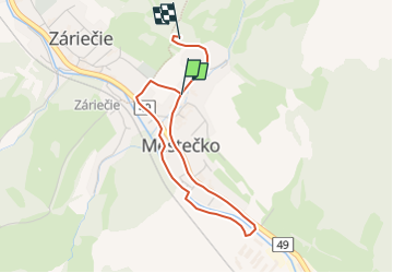
8,9 km | 13,8 km-effort
1h 0min
![](https://static1.geolcdn.com/siteimages/upload/files/16400158638029165_repeat_loop_refresh_sync_direction_icon.png)
Ja
![Tour Zu Fuß Walachisch Klobouk - Naučná stezka Královec - Photo](https://media.geolcdn.com/t/375/260/e77b9c97-4a24-4f58-a17e-bf071e796436.jpeg&format=jpg&maxdim=2)
![Zu Fuß Zu Fuß](https://static1.geolcdn.com/sitytour/trail-icons/100.png)
Naučná stezka Královec
Zu Fuß
Einfach
Walachisch Klobouk,
Mittelmähren,
Region Zlin,
Czech Republic
![](/images/other/stat-length.png)
5,5 km | 8,8 km-effort
2h 0min
![](https://static1.geolcdn.com/siteimages/upload/files/16400158638029165_repeat_loop_refresh_sync_direction_icon.png)
Ja
![Tour Zu Fuß Halenkov - [Z] Provazné - Vsacký Cáb - Photo](https://media.geolcdn.com/t/375/260/1b623b19-8a51-4b12-84ef-c96839aa8d55.jpeg&format=jpg&maxdim=2)
![Zu Fuß Zu Fuß](https://static1.geolcdn.com/sitytour/trail-icons/100.png)
[Z] Provazné - Vsacký Cáb
Zu Fuß
Einfach
Halenkov,
Mittelmähren,
Region Zlin,
Czech Republic
![](/images/other/stat-length.png)
10,4 km | 14,7 km-effort
3h 20min
![](https://static1.geolcdn.com/siteimages/upload/files/16400158638029165_repeat_loop_refresh_sync_direction_icon.png)
Nein
![Tour Zu Fuß okres Považská Bystrica - SK-Local marking made by village Slopna. There are guidepost with defined color for paths, but without physical marking. There are no guideposts outside the Slopna territory even if the path is ending elsewhere. - Photo](https://media.geolcdn.com/t/375/260/c7c1c3c4-4fca-4c0a-906b-a25ff26e4233.jpeg&format=jpg&maxdim=2)
![Zu Fuß Zu Fuß](https://static1.geolcdn.com/sitytour/trail-icons/100.png)
SK-Local marking made by village Slopna. There are guidepost with defined col...
Zu Fuß
Einfach
okres Považská Bystrica,
Trentschiner Landschaftsverband,
Unbekannt,
Slovakia
![](/images/other/stat-length.png)
4,1 km | 9,8 km-effort
2h 14min
![](https://static1.geolcdn.com/siteimages/upload/files/16400158638029165_repeat_loop_refresh_sync_direction_icon.png)
Nein
![Tour Zu Fuß okres Považská Bystrica - Náučný chodník](https://media.geolcdn.com/t/375/260/50322a2f-fdc5-4a64-bc75-23d4093510c8.jpeg&format=jpg&maxdim=2)
![Zu Fuß Zu Fuß](https://static1.geolcdn.com/sitytour/trail-icons/100.png)
Náučný chodník "Obec Papradno"
Zu Fuß
Einfach
okres Považská Bystrica,
Trentschiner Landschaftsverband,
Unbekannt,
Slovakia
![](/images/other/stat-length.png)
4,5 km | 6,7 km-effort
1h 31min
![](https://static1.geolcdn.com/siteimages/upload/files/16400158638029165_repeat_loop_refresh_sync_direction_icon.png)
Nein
![Tour Zu Fuß okres Považská Bystrica - Náučný chodník Milochov - Photo](https://media.geolcdn.com/t/375/260/85de62c4-aafa-497b-9e63-32ff024ca68a.jpeg&format=jpg&maxdim=2)
![Zu Fuß Zu Fuß](https://static1.geolcdn.com/sitytour/trail-icons/100.png)
Náučný chodník Milochov
Zu Fuß
Einfach
okres Považská Bystrica,
Trentschiner Landschaftsverband,
Unbekannt,
Slovakia
![](/images/other/stat-length.png)
5,7 km | 9,3 km-effort
2h 6min
![](https://static1.geolcdn.com/siteimages/upload/files/16400158638029165_repeat_loop_refresh_sync_direction_icon.png)
Nein
![Tour Zu Fuß Bezirk Illau - Náučný chodník](https://media.geolcdn.com/t/375/260/1feded15-0b63-4b62-b9f0-07b7e3b9d500.jpeg&format=jpg&maxdim=2)
![Zu Fuß Zu Fuß](https://static1.geolcdn.com/sitytour/trail-icons/100.png)
Náučný chodník "Okolo Vršatca - koruny Bielych Karpát"
Zu Fuß
Einfach
Bezirk Illau,
Trentschiner Landschaftsverband,
Unbekannt,
Slovakia
![](/images/other/stat-length.png)
5,9 km | 10,3 km-effort
2h 20min
![](https://static1.geolcdn.com/siteimages/upload/files/16400158638029165_repeat_loop_refresh_sync_direction_icon.png)
Ja
![Tour Zu Fuß Bezirk Illau - Lesnícky náučný chodník Bolešov - Krivoklát - Photo](https://media.geolcdn.com/t/375/260/27195c61-194f-4d9a-9868-57e3ca866c7a.jpeg&format=jpg&maxdim=2)
![Zu Fuß Zu Fuß](https://static1.geolcdn.com/sitytour/trail-icons/100.png)
Lesnícky náučný chodník Bolešov - Krivoklát
Zu Fuß
Einfach
Bezirk Illau,
Trentschiner Landschaftsverband,
Unbekannt,
Slovakia
![](/images/other/stat-length.png)
8,2 km | 11,2 km-effort
2h 33min
![](https://static1.geolcdn.com/siteimages/upload/files/16400158638029165_repeat_loop_refresh_sync_direction_icon.png)
Nein