![](/images/other/stat-length.png)
![Tour Zu Fuß Unbekannt - The Sugar Loaf Way - Photo](https://media.geolcdn.com/t/1900/400/16c72303-970b-49d8-80b1-81de04133254.jpeg&format=pjpeg&maxdim=2)
The Sugar Loaf Way
SityTrail - itinéraires balisés pédestres
Tous les sentiers balisés d’Europe GUIDE+
![Länge](/images/other/stat-length.png)
Länge
4,5 km
![Maximale Höhe](https://static1.geolcdn.com/siteimages/upload/files/1508320355ic_sort_altitude_max_24dp.png)
Maximale Höhe
374 m
![Positive Höhendifferenz](https://static1.geolcdn.com/siteimages/upload/files/1508320355ic_sort_den_pos_24dp.png)
Positive Höhendifferenz
286 m
![Km-Effort](/images/other/stat-length.png)
Km-Effort
7,6 km
![Min. Höhe](https://static1.geolcdn.com/siteimages/upload/files/1508320355ic_sort_altitude_min_24dp.png)
Min. Höhe
89 m
![Negative Höhendifferenz](https://static1.geolcdn.com/siteimages/upload/files/1508320355ic_sort_den_neg_24dp.png)
Negative Höhendifferenz
77 m
![Boucle](https://static1.geolcdn.com/siteimages/upload/files/16400158638029165_repeat_loop_refresh_sync_direction_icon.png)
Boucle
Nein
Kennzeichnung
Erstellungsdatum :
2025-02-06 12:58:23.881
Letzte Änderung :
2025-02-06 12:58:23.881
![Zu Fuß](https://static1.geolcdn.com/sitytour/trail-icons/100.png)
1h43
Schwierigkeit : Einfach
![Scannen Sie diesen QR-Code, um die Tour in der SityTrail-Anwendung zu öffnen](https://capi.geolives.com/qq0zvz2zws4bq2lad0pu/sitytour/trails/4342926/qr.png?size=200)
Kostenlosegpshiking-Anwendung
Über SityTrail
Tour Zu Fuß von 4,5 km verfügbar auf Unbekannt, Unbekannt, Unbekannt. Diese Tour wird von SityTrail - itinéraires balisés pédestres vorgeschlagen.
Beschreibung
Tour erstellt von Wicklow Uplands Council.
Symbol: Yellow Hiker
Website: http://www.wicklowuplands.ie/the-sugar-loaf-way-3/
Ort
Land:
Ireland
Region :
Unbekannt
Abteilung/Provinz :
Unbekannt
Kommune :
Unbekannt
Standort:
Glencullen ED
Gehen Sie:(Dec)
Gehen Sie:(UTM)
691352 ; 5894783 (29U) N.
Kommentare
Touren in der Umgebung
![Tour Zu Fuß Unbekannt - De Buitléar Way - Photo](https://media.geolcdn.com/t/375/260/588ab67d-a6be-4dac-b07a-6a4d9f7b2c05.jpeg&format=jpg&maxdim=2)
![Zu Fuß Zu Fuß](https://static1.geolcdn.com/sitytour/trail-icons/100.png)
De Buitléar Way
Zu Fuß
Einfach
Unbekannt,
Unbekannt,
Unbekannt,
Ireland
![](/images/other/stat-length.png)
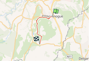
4 km | 6,1 km-effort
1h 23min
![](https://static1.geolcdn.com/siteimages/upload/files/16400158638029165_repeat_loop_refresh_sync_direction_icon.png)
Ja
![Tour Zu Fuß Unbekannt - Bray Greystones Cliff Walk - Photo](https://media.geolcdn.com/t/375/260/a9b1a281-1b41-4857-a0a2-b3252faa0045.jpeg&format=jpg&maxdim=2)
![Zu Fuß Zu Fuß](https://static1.geolcdn.com/sitytour/trail-icons/100.png)
Bray Greystones Cliff Walk
Zu Fuß
Einfach
Unbekannt,
Unbekannt,
Unbekannt,
Ireland
![](/images/other/stat-length.png)
5,8 km | 7,2 km-effort
1h 38min
![](https://static1.geolcdn.com/siteimages/upload/files/16400158638029165_repeat_loop_refresh_sync_direction_icon.png)
Nein
![Tour Zu Fuß The Municipal District of Greystones - Delgany Heritage Trail - Photo](https://media.geolcdn.com/t/375/260/05db524d-a294-4fbf-b3d1-1d3660b1ac69.jpeg&format=jpg&maxdim=2)
![Zu Fuß Zu Fuß](https://static1.geolcdn.com/sitytour/trail-icons/100.png)
Delgany Heritage Trail
Zu Fuß
Einfach
The Municipal District of Greystones,
Unbekannt,
County Wicklow,
Ireland
![](/images/other/stat-length.png)
4,6 km | 6,1 km-effort
1h 22min
![](https://static1.geolcdn.com/siteimages/upload/files/16400158638029165_repeat_loop_refresh_sync_direction_icon.png)
Ja
![Tour Wandern Unbekannt - The Sugarloaf - Photo](https://media.geolcdn.com/t/375/260/ext.jpg?maxdim=2&url=https%3A%2F%2Fstatic1.geolcdn.com%2Fsiteimages%2Fupload%2Ffiles%2F1553511878bg_sport_marche.png)
![Wandern Wandern](https://static1.geolcdn.com/sitytour/trail-icons/101.png)
The Sugarloaf
Wandern
Sehr leicht
Unbekannt,
Unbekannt,
Unbekannt,
Ireland
![](/images/other/stat-length.png)
6,3 km | 11,5 km-effort
Unbekannt
![](https://static1.geolcdn.com/siteimages/upload/files/16400158638029165_repeat_loop_refresh_sync_direction_icon.png)
Nein
![Tour Wandern The Municipal District of Bray - waterfall - Photo](https://media.geolcdn.com/t/375/260/66d40481-bca1-4038-ac65-694f933ef808.jpg&format=jpg&maxdim=2)
![Wandern Wandern](https://static1.geolcdn.com/sitytour/trail-icons/101.png)
waterfall
Wandern
Sehr leicht
The Municipal District of Bray,
Unbekannt,
County Wicklow,
Ireland
![](/images/other/stat-length.png)
961 m | 1,3 km-effort
27min
![](https://static1.geolcdn.com/siteimages/upload/files/16400158638029165_repeat_loop_refresh_sync_direction_icon.png)
Ja