![](/images/other/stat-length.png)
![Tour Zu Fuß Tralee Municipal District - Slí na Sláinte Tralee - Photo](https://media.geolcdn.com/t/1900/400/07816d22-8b72-45aa-aff6-c5903ee3b0bf.jpeg&format=pjpeg&maxdim=2)
Slí na Sláinte Tralee
SityTrail - itinéraires balisés pédestres
Tous les sentiers balisés d’Europe GUIDE+
![Länge](/images/other/stat-length.png)
Länge
9,7 km
![Maximale Höhe](https://static1.geolcdn.com/siteimages/upload/files/1508320355ic_sort_altitude_max_24dp.png)
Maximale Höhe
53 m
![Positive Höhendifferenz](https://static1.geolcdn.com/siteimages/upload/files/1508320355ic_sort_den_pos_24dp.png)
Positive Höhendifferenz
62 m
![Km-Effort](/images/other/stat-length.png)
Km-Effort
10,5 km
![Min. Höhe](https://static1.geolcdn.com/siteimages/upload/files/1508320355ic_sort_altitude_min_24dp.png)
Min. Höhe
0 m
![Negative Höhendifferenz](https://static1.geolcdn.com/siteimages/upload/files/1508320355ic_sort_den_neg_24dp.png)
Negative Höhendifferenz
64 m
![Boucle](https://static1.geolcdn.com/siteimages/upload/files/16400158638029165_repeat_loop_refresh_sync_direction_icon.png)
Boucle
Ja
Kennzeichnung
Erstellungsdatum :
2025-02-06 12:54:21.219
Letzte Änderung :
2025-02-06 12:54:21.219
![Zu Fuß](https://static1.geolcdn.com/sitytour/trail-icons/100.png)
2h23
Schwierigkeit : Einfach
![Scannen Sie diesen QR-Code, um die Tour in der SityTrail-Anwendung zu öffnen](https://capi.geolives.com/qq0zvz2zws4bq2lad0pu/sitytour/trails/4342915/qr.png?size=200)
Kostenlosegpshiking-Anwendung
Über SityTrail
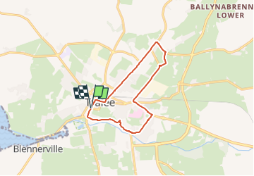
Tour Zu Fuß von 9,7 km verfügbar auf Unbekannt, County Kerry, Tralee Municipal District. Diese Tour wird von SityTrail - itinéraires balisés pédestres vorgeschlagen.
Beschreibung
Tour erstellt von Slí na Sláinte - Irish Heart Foundation.
Route is recommended as a day time walk only
Ort
Land:
Ireland
Region :
Unbekannt
Abteilung/Provinz :
County Kerry
Kommune :
Tralee Municipal District
Standort:
Tralee Urban
Gehen Sie:(Dec)
Gehen Sie:(UTM)
451583 ; 5791016 (29U) N.
Kommentare
Touren in der Umgebung
![Tour Auto Tralee Municipal District - retour - Photo](https://media.geolcdn.com/t/375/260/ext.jpg?maxdim=2&url=https%3A%2F%2Fstatic1.geolcdn.com%2Fsiteimages%2Fupload%2Ffiles%2F15247431544x4.jpg)
![Auto Auto](https://static1.geolcdn.com/sitytour/trail-icons/401.png)
retour
Auto
Sehr leicht
Tralee Municipal District,
Unbekannt,
County Kerry,
Ireland
![](/images/other/stat-length.png)
306 km | 349 km-effort
3h 41min
![](https://static1.geolcdn.com/siteimages/upload/files/16400158638029165_repeat_loop_refresh_sync_direction_icon.png)
Nein
![Tour Elektrofahrrad Tralee Municipal District - de talent à kilarney - Photo](https://media.geolcdn.com/t/375/260/ext.jpg?maxdim=2&url=https%3A%2F%2Fstatic1.geolcdn.com%2Fsiteimages%2Fupload%2Ffiles%2F1524743154velo.jpg)
![Elektrofahrrad Elektrofahrrad](https://static1.geolcdn.com/sitytour/trail-icons/205.png)
de talent à kilarney
Elektrofahrrad
Einfach
Tralee Municipal District,
Unbekannt,
County Kerry,
Ireland
![](/images/other/stat-length.png)
141 km | 155 km-effort
6h 42min
![](https://static1.geolcdn.com/siteimages/upload/files/16400158638029165_repeat_loop_refresh_sync_direction_icon.png)
Nein
![Tour Auto Tralee Municipal District - j03-4 - Photo](https://media.geolcdn.com/t/375/260/ext.jpg?maxdim=2&url=https%3A%2F%2Fstatic1.geolcdn.com%2Fsiteimages%2Fupload%2Ffiles%2F15247431544x4.jpg)
![Auto Auto](https://static1.geolcdn.com/sitytour/trail-icons/401.png)
j03-4
Auto
Sehr leicht
Tralee Municipal District,
Unbekannt,
County Kerry,
Ireland
![](/images/other/stat-length.png)
43 km | 47 km-effort
39min
![](https://static1.geolcdn.com/siteimages/upload/files/16400158638029165_repeat_loop_refresh_sync_direction_icon.png)
Nein
![Tour Wandern Tralee Municipal District - Samen winkelen in Tralee - Photo](https://media.geolcdn.com/t/375/260/ext.jpg?maxdim=2&url=https%3A%2F%2Fstatic1.geolcdn.com%2Fsiteimages%2Fupload%2Ffiles%2F1553511878bg_sport_marche.png)
![Wandern Wandern](https://static1.geolcdn.com/sitytour/trail-icons/101.png)
Samen winkelen in Tralee
Wandern
Tralee Municipal District,
Unbekannt,
County Kerry,
Ireland
![](/images/other/stat-length.png)
30 km | 32 km-effort
38min
![](https://static1.geolcdn.com/siteimages/upload/files/16400158638029165_repeat_loop_refresh_sync_direction_icon.png)
Nein
![Tour Wandern Tralee Municipal District - DW01 - Tralee - Camp - Photo](https://media.geolcdn.com/t/375/260/ext.jpg?maxdim=2&url=https%3A%2F%2Fstatic1.geolcdn.com%2Fsiteimages%2Fupload%2Ffiles%2F1553511878bg_sport_marche.png)
![Wandern Wandern](https://static1.geolcdn.com/sitytour/trail-icons/101.png)
DW01 - Tralee - Camp
Wandern
Medium
Tralee Municipal District,
Unbekannt,
County Kerry,
Ireland
![](/images/other/stat-length.png)
19,6 km | 25 km-effort
5h 18min
![](https://static1.geolcdn.com/siteimages/upload/files/16400158638029165_repeat_loop_refresh_sync_direction_icon.png)
Nein
![Tour Wandern Tralee Municipal District - Tralee - Photo](https://media.geolcdn.com/t/375/260/ext.jpg?maxdim=2&url=https%3A%2F%2Fstatic1.geolcdn.com%2Fsiteimages%2Fupload%2Ffiles%2F1553511878bg_sport_marche.png)
![Wandern Wandern](https://static1.geolcdn.com/sitytour/trail-icons/101.png)
Tralee
Wandern
Tralee Municipal District,
Unbekannt,
County Kerry,
Ireland
![](/images/other/stat-length.png)
1,7 km | 1,7 km-effort
1h 47min
![](https://static1.geolcdn.com/siteimages/upload/files/16400158638029165_repeat_loop_refresh_sync_direction_icon.png)
Ja