![](/images/other/stat-length.png)
![Tour Wandern Valloire-sur-Cisse - BBR 2025-01-29 Coulanges - Chouzy-sur-Cisse 15 km - Photo](https://media.geolcdn.com/t/1900/400/ext.pjpeg?maxdim=2&url=https%3A%2F%2Fstatic1.geolcdn.com%2Fsiteimages%2Fupload%2Ffiles%2F1553511878bg_sport_marche.png)
BBR 2025-01-29 Coulanges - Chouzy-sur-Cisse 15 km
marionneau
Benutzer
![Länge](/images/other/stat-length.png)
Länge
14,4 km
![Maximale Höhe](https://static1.geolcdn.com/siteimages/upload/files/1508320355ic_sort_altitude_max_24dp.png)
Maximale Höhe
123 m
![Positive Höhendifferenz](https://static1.geolcdn.com/siteimages/upload/files/1508320355ic_sort_den_pos_24dp.png)
Positive Höhendifferenz
152 m
![Km-Effort](/images/other/stat-length.png)
Km-Effort
16,4 km
![Min. Höhe](https://static1.geolcdn.com/siteimages/upload/files/1508320355ic_sort_altitude_min_24dp.png)
Min. Höhe
63 m
![Negative Höhendifferenz](https://static1.geolcdn.com/siteimages/upload/files/1508320355ic_sort_den_neg_24dp.png)
Negative Höhendifferenz
154 m
![Boucle](https://static1.geolcdn.com/siteimages/upload/files/16400158638029165_repeat_loop_refresh_sync_direction_icon.png)
Boucle
Ja
Erstellungsdatum :
2025-01-28 21:16:59.344
Letzte Änderung :
2025-01-28 21:18:30.384
![Wandern](https://static1.geolcdn.com/sitytour/trail-icons/101.png)
3h03
Schwierigkeit : Medium
![Scannen Sie diesen QR-Code, um die Tour in der SityTrail-Anwendung zu öffnen](https://capi.geolives.com/qq0zvz2zws4bq2lad0pu/sitytour/trails/4333243/qr.png?size=200)
Kostenlosegpshiking-Anwendung
Über SityTrail
Tour Wandern von 14,4 km verfügbar auf Zentrum-Loiretal, Loir-et-Cher, Valloire-sur-Cisse. Diese Tour wird von marionneau vorgeschlagen.
Beschreibung
D'après reconnaissance faite le dimanche 26-01-2025 Mireille - Catherine - Patrick
Puis nouvelles modifications après fortes pluies lundi 27 et mardi 28 ! (le bord de Cisse est complètement impraticable)
Ort
Land:
France
Region :
Zentrum-Loiretal
Abteilung/Provinz :
Loir-et-Cher
Kommune :
Valloire-sur-Cisse
Standort:
Unknown
Gehen Sie:(Dec)
Gehen Sie:(UTM)
366367 ; 5266875 (31T) N.
Kommentare
Touren in der Umgebung
![Tour Wandern Valencisse - Circuit n°4 de Moulineuf - Photo](https://media.geolcdn.com/t/375/260/ext.jpg?maxdim=2&url=https%3A%2F%2Fservices.sitytrail.com%2FGeolivesWS%2FDownloadMedia.ashx%3FTrailID%3D317925%26Media%3D17343_6.jpg)
![Wandern Wandern](https://static1.geolcdn.com/sitytour/trail-icons/101.png)
Circuit n°4 de Moulineuf
Wandern
Medium
(1)
Valencisse,
Zentrum-Loiretal,
Loir-et-Cher,
France
![](/images/other/stat-length.png)
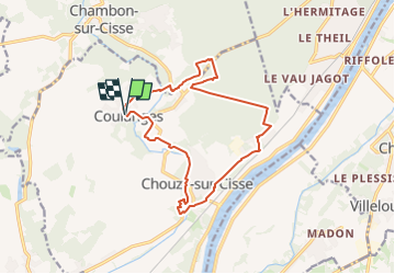
15 km | 18,4 km-effort
3h 45min
![](https://static1.geolcdn.com/siteimages/upload/files/16400158638029165_repeat_loop_refresh_sync_direction_icon.png)
Ja
![Tour Mountainbike Valloire-sur-Cisse - Vignoble et Cisse - Chouzy sur Cisse - Photo](https://media.geolcdn.com/t/375/260/ext.jpg?maxdim=2&url=https%3A%2F%2Fservices.sitytrail.com%2FGeolivesWS%2FDownloadMedia.ashx%3FTrailID%3D317889%26Media%3D17292_6.jpg)
![Mountainbike Mountainbike](https://static1.geolcdn.com/sitytour/trail-icons/202.png)
Vignoble et Cisse - Chouzy sur Cisse
Mountainbike
Medium
(2)
Valloire-sur-Cisse,
Zentrum-Loiretal,
Loir-et-Cher,
France
![](/images/other/stat-length.png)
18,8 km | 21 km-effort
1h 30min
![](https://static1.geolcdn.com/siteimages/upload/files/16400158638029165_repeat_loop_refresh_sync_direction_icon.png)
Ja
![Tour Wandern Valencisse - BBR 2025-02-01 Valentine de Milan 10km - Photo](https://media.geolcdn.com/t/375/260/ext.jpg?maxdim=2&url=https%3A%2F%2Fstatic1.geolcdn.com%2Fsiteimages%2Fupload%2Ffiles%2F1553511878bg_sport_marche.png)
![Wandern Wandern](https://static1.geolcdn.com/sitytour/trail-icons/101.png)
BBR 2025-02-01 Valentine de Milan 10km
Wandern
Medium
(1)
Valencisse,
Zentrum-Loiretal,
Loir-et-Cher,
France
![](/images/other/stat-length.png)
10,7 km | 12 km-effort
1h 35min
![](https://static1.geolcdn.com/siteimages/upload/files/16400158638029165_repeat_loop_refresh_sync_direction_icon.png)
Ja
![Tour Wandern Candé-sur-Beuvron - BBR 2024-07-30 Candé-sur-Beuvron Valaire Boucle 15 Km - Photo](https://media.geolcdn.com/t/375/260/ext.jpg?maxdim=2&url=https%3A%2F%2Fstatic1.geolcdn.com%2Fsiteimages%2Fupload%2Ffiles%2F1553511878bg_sport_marche.png)
![Wandern Wandern](https://static1.geolcdn.com/sitytour/trail-icons/101.png)
BBR 2024-07-30 Candé-sur-Beuvron Valaire Boucle 15 Km
Wandern
Medium
(1)
Candé-sur-Beuvron,
Zentrum-Loiretal,
Loir-et-Cher,
France
![](/images/other/stat-length.png)
15,2 km | 17,2 km-effort
3h 54min
![](https://static1.geolcdn.com/siteimages/upload/files/16400158638029165_repeat_loop_refresh_sync_direction_icon.png)
Ja
![Tour Wandern Veuzain-sur-Loire - Onzain - GR3 Chouzy-sur-Cisse GR353B - 24.7km 250m 5h45 (30mn) - 2022 09 18 - Photo](https://media.geolcdn.com/t/375/260/7be7e1ff-5ac8-493b-b202-21094f0fc660.jpg&format=jpg&maxdim=2)
![Wandern Wandern](https://static1.geolcdn.com/sitytour/trail-icons/101.png)
Onzain - GR3 Chouzy-sur-Cisse GR353B - 24.7km 250m 5h45 (30mn) - 2022 09 18
Wandern
Medium
Veuzain-sur-Loire,
Zentrum-Loiretal,
Loir-et-Cher,
France
![](/images/other/stat-length.png)
25 km | 28 km-effort
5h 45min
![](https://static1.geolcdn.com/siteimages/upload/files/16400158638029165_repeat_loop_refresh_sync_direction_icon.png)
Ja
![Tour Zu Fuß Valencisse - Chambon-Molineuf par Champigny - Photo](https://media.geolcdn.com/t/375/260/ext.jpg?maxdim=2&url=https%3A%2F%2Fstatic1.geolcdn.com%2Fsiteimages%2Fupload%2Ffiles%2F1545311037marcheuse_200dpi.jpg)
![Zu Fuß Zu Fuß](https://static1.geolcdn.com/sitytour/trail-icons/100.png)
Chambon-Molineuf par Champigny
Zu Fuß
Einfach
(1)
Valencisse,
Zentrum-Loiretal,
Loir-et-Cher,
France
![](/images/other/stat-length.png)
14,7 km | 18,1 km-effort
Unbekannt
![](https://static1.geolcdn.com/siteimages/upload/files/16400158638029165_repeat_loop_refresh_sync_direction_icon.png)
Ja
![Tour Wandern Valencisse - les rinceaux - Photo](https://media.geolcdn.com/t/375/260/5ccb405d-d4f6-4381-9494-3cfd59f9f42e.jpg&format=jpg&maxdim=2)
![Wandern Wandern](https://static1.geolcdn.com/sitytour/trail-icons/101.png)
les rinceaux
Wandern
Medium
Valencisse,
Zentrum-Loiretal,
Loir-et-Cher,
France
![](/images/other/stat-length.png)
9,1 km | 10,8 km-effort
3h 13min
![](https://static1.geolcdn.com/siteimages/upload/files/16400158638029165_repeat_loop_refresh_sync_direction_icon.png)
Ja
![Tour Wandern Valloire-sur-Cisse - Randonnée BBR du 18 novembre 2020 - Photo](https://media.geolcdn.com/t/375/260/d5721fd4-941b-4b90-8a20-e6d5dc2dbd16.jpg&format=jpg&maxdim=2)
![Wandern Wandern](https://static1.geolcdn.com/sitytour/trail-icons/101.png)
Randonnée BBR du 18 novembre 2020
Wandern
Sehr leicht
Valloire-sur-Cisse,
Zentrum-Loiretal,
Loir-et-Cher,
France
![](/images/other/stat-length.png)
13,8 km | 15,5 km-effort
2h 50min
![](https://static1.geolcdn.com/siteimages/upload/files/16400158638029165_repeat_loop_refresh_sync_direction_icon.png)
Ja
![Tour Wandern Valencisse - Circuit n°3 de Molineuf - Photo](https://media.geolcdn.com/t/375/260/ext.jpg?maxdim=2&url=https%3A%2F%2Fservices.sitytrail.com%2FGeolivesWS%2FDownloadMedia.ashx%3FTrailID%3D317924%26Media%3D17342_5.jpg)
![Wandern Wandern](https://static1.geolcdn.com/sitytour/trail-icons/101.png)
Circuit n°3 de Molineuf
Wandern
Medium
Valencisse,
Zentrum-Loiretal,
Loir-et-Cher,
France
![](/images/other/stat-length.png)
12,3 km | 14,6 km-effort
3h 0min
![](https://static1.geolcdn.com/siteimages/upload/files/16400158638029165_repeat_loop_refresh_sync_direction_icon.png)
Ja