![](/images/other/stat-length.png)
![Tour Andere Aktivitäten Marly - 522/Marly Grand-Pré/Bourguillon-Manège-Roule-Grotte/R - Photo](https://media.geolcdn.com/t/1900/400/ext.pjpeg?maxdim=2&url=https%3A%2F%2Fstatic1.geolcdn.com%2Fsiteimages%2Fupload%2Ffiles%2F1545311037marcheuse_200dpi.jpg)
522/Marly Grand-Pré/Bourguillon-Manège-Roule-Grotte/R
nordicmarly
Benutzer
![Länge](/images/other/stat-length.png)
Länge
10,2 km
![Maximale Höhe](https://static1.geolcdn.com/siteimages/upload/files/1508320355ic_sort_altitude_max_24dp.png)
Maximale Höhe
756 m
![Positive Höhendifferenz](https://static1.geolcdn.com/siteimages/upload/files/1508320355ic_sort_den_pos_24dp.png)
Positive Höhendifferenz
206 m
![Km-Effort](/images/other/stat-length.png)
Km-Effort
13 km
![Min. Höhe](https://static1.geolcdn.com/siteimages/upload/files/1508320355ic_sort_altitude_min_24dp.png)
Min. Höhe
616 m
![Negative Höhendifferenz](https://static1.geolcdn.com/siteimages/upload/files/1508320355ic_sort_den_neg_24dp.png)
Negative Höhendifferenz
206 m
![Boucle](https://static1.geolcdn.com/siteimages/upload/files/16400158638029165_repeat_loop_refresh_sync_direction_icon.png)
Boucle
Ja
Erstellungsdatum :
2014-12-10 00:00:00.0
Letzte Änderung :
2014-12-10 00:00:00.0
![Andere Aktivitäten](https://static1.geolcdn.com/sitytour/trail-icons/900.png)
--
Schwierigkeit : Unbekannt
![Scannen Sie diesen QR-Code, um die Tour in der SityTrail-Anwendung zu öffnen](https://capi.geolives.com/qq0zvz2zws4bq2lad0pu/sitytour/trails/43277/qr.png?size=200)
Kostenlosegpshiking-Anwendung
Über SityTrail
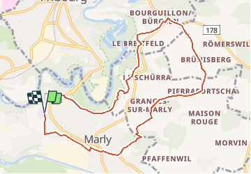
Tour Andere Aktivitäten von 10,2 km verfügbar auf Freiburg, District de la Sarine, Marly. Diese Tour wird von nordicmarly vorgeschlagen.
Beschreibung
Grand Pré
Chemin des Falaises
Sentier Botanique
Bourgillon
Route de Lac Noir
Chemin de Brünisberg
Pierrafortscha
Manège
Bois du Roule
Grotte
Route des Préalpes
Chemin des Epinettes
Entre les fermes
Grand Pré
Ort
Land:
Switzerland
Region :
Freiburg
Abteilung/Provinz :
District de la Sarine
Kommune :
Marly
Standort:
Unknown
Gehen Sie:(Dec)
Gehen Sie:(UTM)
358536 ; 5182753 (32T) N.
Kommentare
Touren in der Umgebung
![Tour Zu Fuß Glanewiler - Tour des trois rivières - Photo](https://media.geolcdn.com/t/375/260/50fb974f-7178-4c1e-8fa3-33696ba9387d.jpeg&format=jpg&maxdim=2)
![Zu Fuß Zu Fuß](https://static1.geolcdn.com/sitytour/trail-icons/100.png)
Tour des trois rivières
Zu Fuß
Einfach
Glanewiler,
Freiburg,
District de la Sarine,
Switzerland
![](/images/other/stat-length.png)
5,1 km | 7,1 km-effort
1h 36min
![](https://static1.geolcdn.com/siteimages/upload/files/16400158638029165_repeat_loop_refresh_sync_direction_icon.png)
Nein
![Tour Zu Fuß Hauterive (FR) - Circuit Hauterive - Photo](https://media.geolcdn.com/t/375/260/0d2a055c-cfc9-4111-95d9-78b65bbb9d7b.jpeg&format=jpg&maxdim=2)
![Zu Fuß Zu Fuß](https://static1.geolcdn.com/sitytour/trail-icons/100.png)
Circuit Hauterive
Zu Fuß
Einfach
Hauterive (FR),
Freiburg,
District de la Sarine,
Switzerland
![](/images/other/stat-length.png)
5 km | 6,7 km-effort
1h 31min
![](https://static1.geolcdn.com/siteimages/upload/files/16400158638029165_repeat_loop_refresh_sync_direction_icon.png)
Nein
![Tour Zu Fuß Hauterive (FR) - Hauterive - La Tuffière - Photo](https://media.geolcdn.com/t/375/260/0d2a055c-cfc9-4111-95d9-78b65bbb9d7b.jpeg&format=jpg&maxdim=2)
![Zu Fuß Zu Fuß](https://static1.geolcdn.com/sitytour/trail-icons/100.png)
Hauterive - La Tuffière
Zu Fuß
Einfach
Hauterive (FR),
Freiburg,
District de la Sarine,
Switzerland
![](/images/other/stat-length.png)
5 km | 6,6 km-effort
1h 30min
![](https://static1.geolcdn.com/siteimages/upload/files/16400158638029165_repeat_loop_refresh_sync_direction_icon.png)
Nein
![Tour Zu Fuß Matran - Matran - Noréaz - Photo](https://media.geolcdn.com/t/375/260/7a2244db-87fb-4c17-aec0-e64a7984f7bf.jpeg&format=jpg&maxdim=2)
![Zu Fuß Zu Fuß](https://static1.geolcdn.com/sitytour/trail-icons/100.png)
Matran - Noréaz
Zu Fuß
Einfach
Matran,
Freiburg,
District de la Sarine,
Switzerland
![](/images/other/stat-length.png)
5,9 km | 7,2 km-effort
1h 38min
![](https://static1.geolcdn.com/siteimages/upload/files/16400158638029165_repeat_loop_refresh_sync_direction_icon.png)
Nein
![Tour Zu Fuß Hauterive (FR) - Circuit de La Tuffière - Photo](https://media.geolcdn.com/t/375/260/0d2a055c-cfc9-4111-95d9-78b65bbb9d7b.jpeg&format=jpg&maxdim=2)
![Zu Fuß Zu Fuß](https://static1.geolcdn.com/sitytour/trail-icons/100.png)
Circuit de La Tuffière
Zu Fuß
Einfach
Hauterive (FR),
Freiburg,
District de la Sarine,
Switzerland
![](/images/other/stat-length.png)
6,2 km | 8,2 km-effort
1h 52min
![](https://static1.geolcdn.com/siteimages/upload/files/16400158638029165_repeat_loop_refresh_sync_direction_icon.png)
Nein
![Tour Zu Fuß Hauterive (FR) - Grangeneuve - La Tuffière - Photo](https://media.geolcdn.com/t/375/260/a63f5649-2efe-45fa-bfef-a4d56ef9f525.jpeg&format=jpg&maxdim=2)
![Zu Fuß Zu Fuß](https://static1.geolcdn.com/sitytour/trail-icons/100.png)
Grangeneuve - La Tuffière
Zu Fuß
Einfach
Hauterive (FR),
Freiburg,
District de la Sarine,
Switzerland
![](/images/other/stat-length.png)
5 km | 6,6 km-effort
1h 29min
![](https://static1.geolcdn.com/siteimages/upload/files/16400158638029165_repeat_loop_refresh_sync_direction_icon.png)
Nein
![Tour Zu Fuß Freiburg - Bourguillon - Schürmatt - Photo](https://media.geolcdn.com/t/375/260/c072d18f-e4ff-49d2-980f-d857947059bb.jpeg&format=jpg&maxdim=2)
![Zu Fuß Zu Fuß](https://static1.geolcdn.com/sitytour/trail-icons/100.png)
Bourguillon - Schürmatt
Zu Fuß
Einfach
Freiburg,
Freiburg,
District de la Sarine,
Switzerland
![](/images/other/stat-length.png)
3,9 km | 5,5 km-effort
1h 14min
![](https://static1.geolcdn.com/siteimages/upload/files/16400158638029165_repeat_loop_refresh_sync_direction_icon.png)
Nein
![Tour Zu Fuß Freiburg - Freiburg - Fribourg (Jura) - Photo](https://media.geolcdn.com/t/375/260/bd747e02-b2c4-4e8d-9274-ea5285c3be0a.jpeg&format=jpg&maxdim=2)
![Zu Fuß Zu Fuß](https://static1.geolcdn.com/sitytour/trail-icons/100.png)
Freiburg - Fribourg (Jura)
Zu Fuß
Einfach
Freiburg,
Freiburg,
District de la Sarine,
Switzerland
![](/images/other/stat-length.png)
3,8 km | 5,5 km-effort
1h 15min
![](https://static1.geolcdn.com/siteimages/upload/files/16400158638029165_repeat_loop_refresh_sync_direction_icon.png)
Nein
![Tour Zu Fuß Freiburg - Freiburg / Fribourg Balm / La Palme - Maggenberg - Photo](https://media.geolcdn.com/t/375/260/7a71c5bd-8e93-4c9f-9085-6acad23f2d78.jpeg&format=jpg&maxdim=2)
![Zu Fuß Zu Fuß](https://static1.geolcdn.com/sitytour/trail-icons/100.png)
Freiburg / Fribourg Balm / La Palme - Maggenberg
Zu Fuß
Einfach
Freiburg,
Freiburg,
District de la Sarine,
Switzerland
![](/images/other/stat-length.png)
4,5 km | 7 km-effort
1h 35min
![](https://static1.geolcdn.com/siteimages/upload/files/16400158638029165_repeat_loop_refresh_sync_direction_icon.png)
Nein