![](/images/other/stat-length.png)
![Tour Andere Aktivitäten Marly - 524/Marly Grand-Pré/Passerelle du Port-Bois des Morts-Ritter-Pisciculture/R - Photo](https://media.geolcdn.com/t/1900/400/ext.pjpeg?maxdim=2&url=https%3A%2F%2Fstatic1.geolcdn.com%2Fsiteimages%2Fupload%2Ffiles%2F1545311037marcheuse_200dpi.jpg)
524/Marly Grand-Pré/Passerelle du Port-Bois des Morts-Ritter-Pisciculture/R
nordicmarly
Benutzer
![Länge](/images/other/stat-length.png)
![Maximale Höhe](https://static1.geolcdn.com/siteimages/upload/files/1508320355ic_sort_altitude_max_24dp.png)
![Positive Höhendifferenz](https://static1.geolcdn.com/siteimages/upload/files/1508320355ic_sort_den_pos_24dp.png)
![Km-Effort](/images/other/stat-length.png)
![Min. Höhe](https://static1.geolcdn.com/siteimages/upload/files/1508320355ic_sort_altitude_min_24dp.png)
![Negative Höhendifferenz](https://static1.geolcdn.com/siteimages/upload/files/1508320355ic_sort_den_neg_24dp.png)
![Boucle](https://static1.geolcdn.com/siteimages/upload/files/16400158638029165_repeat_loop_refresh_sync_direction_icon.png)
![Andere Aktivitäten](https://static1.geolcdn.com/sitytour/trail-icons/900.png)
--
Schwierigkeit : Unbekannt
![Scannen Sie diesen QR-Code, um die Tour in der SityTrail-Anwendung zu öffnen](https://capi.geolives.com/qq0zvz2zws4bq2lad0pu/sitytour/trails/43260/qr.png?size=200)
Kostenlosegpshiking-Anwendung
Über SityTrail
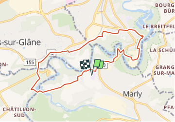
Tour Andere Aktivitäten von 9,1 km verfügbar auf Freiburg, District de la Sarine, Marly. Diese Tour wird von nordicmarly vorgeschlagen.
Beschreibung
Marly Grand Pré
Rte de Fribourg
Dessous le pont de Pérolles
Pisciculture
Sentier Schoch
Bois de Pérolles
G. Ritter
Traverser Bv. de Pérolles
Chocolat Villars (ne pas s''arrêter !!)
Ch. des Cliniques
St-Nicolas-de-Flüe
Bois des Morts
Planafaye
Rte de la Glâne
Pont de la Glâne
Descendre (ou monter jeudi)nouvelle passerelle du Port
Rte de la Gérine
Riedelet
Marly Grand pré
Ort
Kommentare
Touren in der Umgebung
![Tour Zu Fuß Glanewiler - Tour des trois rivières - Photo](https://media.geolcdn.com/t/375/260/50fb974f-7178-4c1e-8fa3-33696ba9387d.jpeg&format=jpg&maxdim=2)
![Zu Fuß Zu Fuß](https://static1.geolcdn.com/sitytour/trail-icons/100.png)
Zu Fuß
![](/images/other/stat-length.png)
![](https://static1.geolcdn.com/siteimages/upload/files/16400158638029165_repeat_loop_refresh_sync_direction_icon.png)
![Tour Zu Fuß Hauterive (FR) - Circuit Hauterive - Photo](https://media.geolcdn.com/t/375/260/0d2a055c-cfc9-4111-95d9-78b65bbb9d7b.jpeg&format=jpg&maxdim=2)
![Zu Fuß Zu Fuß](https://static1.geolcdn.com/sitytour/trail-icons/100.png)
Zu Fuß
![](/images/other/stat-length.png)
![](https://static1.geolcdn.com/siteimages/upload/files/16400158638029165_repeat_loop_refresh_sync_direction_icon.png)
![Tour Zu Fuß Hauterive (FR) - Hauterive - La Tuffière - Photo](https://media.geolcdn.com/t/375/260/0d2a055c-cfc9-4111-95d9-78b65bbb9d7b.jpeg&format=jpg&maxdim=2)
![Zu Fuß Zu Fuß](https://static1.geolcdn.com/sitytour/trail-icons/100.png)
Zu Fuß
![](/images/other/stat-length.png)
![](https://static1.geolcdn.com/siteimages/upload/files/16400158638029165_repeat_loop_refresh_sync_direction_icon.png)
![Tour Zu Fuß Matran - Matran - Noréaz - Photo](https://media.geolcdn.com/t/375/260/7a2244db-87fb-4c17-aec0-e64a7984f7bf.jpeg&format=jpg&maxdim=2)
![Zu Fuß Zu Fuß](https://static1.geolcdn.com/sitytour/trail-icons/100.png)
Zu Fuß
![](/images/other/stat-length.png)
![](https://static1.geolcdn.com/siteimages/upload/files/16400158638029165_repeat_loop_refresh_sync_direction_icon.png)
![Tour Zu Fuß Hauterive (FR) - Circuit de La Tuffière - Photo](https://media.geolcdn.com/t/375/260/0d2a055c-cfc9-4111-95d9-78b65bbb9d7b.jpeg&format=jpg&maxdim=2)
![Zu Fuß Zu Fuß](https://static1.geolcdn.com/sitytour/trail-icons/100.png)
Zu Fuß
![](/images/other/stat-length.png)
![](https://static1.geolcdn.com/siteimages/upload/files/16400158638029165_repeat_loop_refresh_sync_direction_icon.png)
![Tour Zu Fuß Hauterive (FR) - Grangeneuve - La Tuffière - Photo](https://media.geolcdn.com/t/375/260/a63f5649-2efe-45fa-bfef-a4d56ef9f525.jpeg&format=jpg&maxdim=2)
![Zu Fuß Zu Fuß](https://static1.geolcdn.com/sitytour/trail-icons/100.png)
Zu Fuß
![](/images/other/stat-length.png)
![](https://static1.geolcdn.com/siteimages/upload/files/16400158638029165_repeat_loop_refresh_sync_direction_icon.png)
![Tour Zu Fuß Freiburg - Bourguillon - Schürmatt - Photo](https://media.geolcdn.com/t/375/260/c072d18f-e4ff-49d2-980f-d857947059bb.jpeg&format=jpg&maxdim=2)
![Zu Fuß Zu Fuß](https://static1.geolcdn.com/sitytour/trail-icons/100.png)
Zu Fuß
![](/images/other/stat-length.png)
![](https://static1.geolcdn.com/siteimages/upload/files/16400158638029165_repeat_loop_refresh_sync_direction_icon.png)
![Tour Zu Fuß Freiburg - Freiburg - Fribourg (Jura) - Photo](https://media.geolcdn.com/t/375/260/bd747e02-b2c4-4e8d-9274-ea5285c3be0a.jpeg&format=jpg&maxdim=2)
![Zu Fuß Zu Fuß](https://static1.geolcdn.com/sitytour/trail-icons/100.png)
Zu Fuß
![](/images/other/stat-length.png)
![](https://static1.geolcdn.com/siteimages/upload/files/16400158638029165_repeat_loop_refresh_sync_direction_icon.png)
![Tour Zu Fuß Freiburg - Freiburg / Fribourg Balm / La Palme - Maggenberg - Photo](https://media.geolcdn.com/t/375/260/7a71c5bd-8e93-4c9f-9085-6acad23f2d78.jpeg&format=jpg&maxdim=2)
![Zu Fuß Zu Fuß](https://static1.geolcdn.com/sitytour/trail-icons/100.png)
Zu Fuß
![](/images/other/stat-length.png)
![](https://static1.geolcdn.com/siteimages/upload/files/16400158638029165_repeat_loop_refresh_sync_direction_icon.png)