![](/images/other/stat-length.png)
![Tour Andere Aktivitäten Freiburg - 101/Bourguillon/Ameismühle/M - Photo](https://media.geolcdn.com/t/1900/400/ext.pjpeg?maxdim=2&url=https%3A%2F%2Fstatic1.geolcdn.com%2Fsiteimages%2Fupload%2Ffiles%2F1545311037marcheuse_200dpi.jpg)
101/Bourguillon/Ameismühle/M
nordicmarly
Benutzer
![Länge](/images/other/stat-length.png)
Länge
8,9 km
![Maximale Höhe](https://static1.geolcdn.com/siteimages/upload/files/1508320355ic_sort_altitude_max_24dp.png)
Maximale Höhe
751 m
![Positive Höhendifferenz](https://static1.geolcdn.com/siteimages/upload/files/1508320355ic_sort_den_pos_24dp.png)
Positive Höhendifferenz
204 m
![Km-Effort](/images/other/stat-length.png)
Km-Effort
11,6 km
![Min. Höhe](https://static1.geolcdn.com/siteimages/upload/files/1508320355ic_sort_altitude_min_24dp.png)
Min. Höhe
631 m
![Negative Höhendifferenz](https://static1.geolcdn.com/siteimages/upload/files/1508320355ic_sort_den_neg_24dp.png)
Negative Höhendifferenz
205 m
![Boucle](https://static1.geolcdn.com/siteimages/upload/files/16400158638029165_repeat_loop_refresh_sync_direction_icon.png)
Boucle
Ja
Erstellungsdatum :
2014-12-10 00:00:00.0
Letzte Änderung :
2014-12-10 00:00:00.0
![Andere Aktivitäten](https://static1.geolcdn.com/sitytour/trail-icons/900.png)
--
Schwierigkeit : Unbekannt
![Scannen Sie diesen QR-Code, um die Tour in der SityTrail-Anwendung zu öffnen](https://capi.geolives.com/qq0zvz2zws4bq2lad0pu/sitytour/trails/43217/qr.png?size=200)
Kostenlosegpshiking-Anwendung
Über SityTrail
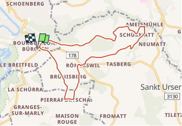
Tour Andere Aktivitäten von 8,9 km verfügbar auf Freiburg, District de la Sarine, Freiburg. Diese Tour wird von nordicmarly vorgeschlagen.
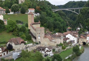
Beschreibung
Bourguillon
Brünisberg
Pierrafortscha
Römerswil
Balterswil
Ameismühle
Schürmatt
Tannholz
Bürglenholz
Bourguillon
Ort
Land:
Switzerland
Region :
Freiburg
Abteilung/Provinz :
District de la Sarine
Kommune :
Freiburg
Standort:
Unknown
Gehen Sie:(Dec)
Gehen Sie:(UTM)
360819 ; 5184408 (32T) N.
Kommentare
Touren in der Umgebung
![Tour Zu Fuß Glanewiler - Tour des trois rivières - Photo](https://media.geolcdn.com/t/375/260/50fb974f-7178-4c1e-8fa3-33696ba9387d.jpeg&format=jpg&maxdim=2)
![Zu Fuß Zu Fuß](https://static1.geolcdn.com/sitytour/trail-icons/100.png)
Tour des trois rivières
Zu Fuß
Einfach
Glanewiler,
Freiburg,
District de la Sarine,
Switzerland
![](/images/other/stat-length.png)
5,1 km | 7,1 km-effort
1h 36min
![](https://static1.geolcdn.com/siteimages/upload/files/16400158638029165_repeat_loop_refresh_sync_direction_icon.png)
Nein
![Tour Zu Fuß Hauterive (FR) - Circuit Hauterive - Photo](https://media.geolcdn.com/t/375/260/0d2a055c-cfc9-4111-95d9-78b65bbb9d7b.jpeg&format=jpg&maxdim=2)
![Zu Fuß Zu Fuß](https://static1.geolcdn.com/sitytour/trail-icons/100.png)
Circuit Hauterive
Zu Fuß
Einfach
Hauterive (FR),
Freiburg,
District de la Sarine,
Switzerland
![](/images/other/stat-length.png)
5 km | 6,7 km-effort
1h 31min
![](https://static1.geolcdn.com/siteimages/upload/files/16400158638029165_repeat_loop_refresh_sync_direction_icon.png)
Nein
![Tour Zu Fuß Hauterive (FR) - Hauterive - La Tuffière - Photo](https://media.geolcdn.com/t/375/260/0d2a055c-cfc9-4111-95d9-78b65bbb9d7b.jpeg&format=jpg&maxdim=2)
![Zu Fuß Zu Fuß](https://static1.geolcdn.com/sitytour/trail-icons/100.png)
Hauterive - La Tuffière
Zu Fuß
Einfach
Hauterive (FR),
Freiburg,
District de la Sarine,
Switzerland
![](/images/other/stat-length.png)
5 km | 6,6 km-effort
1h 30min
![](https://static1.geolcdn.com/siteimages/upload/files/16400158638029165_repeat_loop_refresh_sync_direction_icon.png)
Nein
![Tour Zu Fuß Hauterive (FR) - Circuit de La Tuffière - Photo](https://media.geolcdn.com/t/375/260/0d2a055c-cfc9-4111-95d9-78b65bbb9d7b.jpeg&format=jpg&maxdim=2)
![Zu Fuß Zu Fuß](https://static1.geolcdn.com/sitytour/trail-icons/100.png)
Circuit de La Tuffière
Zu Fuß
Einfach
Hauterive (FR),
Freiburg,
District de la Sarine,
Switzerland
![](/images/other/stat-length.png)
6,2 km | 8,2 km-effort
1h 52min
![](https://static1.geolcdn.com/siteimages/upload/files/16400158638029165_repeat_loop_refresh_sync_direction_icon.png)
Nein
![Tour Zu Fuß Hauterive (FR) - Grangeneuve - La Tuffière - Photo](https://media.geolcdn.com/t/375/260/a63f5649-2efe-45fa-bfef-a4d56ef9f525.jpeg&format=jpg&maxdim=2)
![Zu Fuß Zu Fuß](https://static1.geolcdn.com/sitytour/trail-icons/100.png)
Grangeneuve - La Tuffière
Zu Fuß
Einfach
Hauterive (FR),
Freiburg,
District de la Sarine,
Switzerland
![](/images/other/stat-length.png)
5 km | 6,6 km-effort
1h 29min
![](https://static1.geolcdn.com/siteimages/upload/files/16400158638029165_repeat_loop_refresh_sync_direction_icon.png)
Nein
![Tour Zu Fuß Freiburg - Bourguillon - Schürmatt - Photo](https://media.geolcdn.com/t/375/260/c072d18f-e4ff-49d2-980f-d857947059bb.jpeg&format=jpg&maxdim=2)
![Zu Fuß Zu Fuß](https://static1.geolcdn.com/sitytour/trail-icons/100.png)
Bourguillon - Schürmatt
Zu Fuß
Einfach
Freiburg,
Freiburg,
District de la Sarine,
Switzerland
![](/images/other/stat-length.png)
3,9 km | 5,5 km-effort
1h 14min
![](https://static1.geolcdn.com/siteimages/upload/files/16400158638029165_repeat_loop_refresh_sync_direction_icon.png)
Nein
![Tour Zu Fuß Freiburg - Freiburg - Fribourg (Jura) - Photo](https://media.geolcdn.com/t/375/260/bd747e02-b2c4-4e8d-9274-ea5285c3be0a.jpeg&format=jpg&maxdim=2)
![Zu Fuß Zu Fuß](https://static1.geolcdn.com/sitytour/trail-icons/100.png)
Freiburg - Fribourg (Jura)
Zu Fuß
Einfach
Freiburg,
Freiburg,
District de la Sarine,
Switzerland
![](/images/other/stat-length.png)
3,8 km | 5,5 km-effort
1h 15min
![](https://static1.geolcdn.com/siteimages/upload/files/16400158638029165_repeat_loop_refresh_sync_direction_icon.png)
Nein
![Tour Zu Fuß Freiburg - Freiburg / Fribourg Balm / La Palme - Maggenberg - Photo](https://media.geolcdn.com/t/375/260/7a71c5bd-8e93-4c9f-9085-6acad23f2d78.jpeg&format=jpg&maxdim=2)
![Zu Fuß Zu Fuß](https://static1.geolcdn.com/sitytour/trail-icons/100.png)
Freiburg / Fribourg Balm / La Palme - Maggenberg
Zu Fuß
Einfach
Freiburg,
Freiburg,
District de la Sarine,
Switzerland
![](/images/other/stat-length.png)
4,5 km | 7 km-effort
1h 35min
![](https://static1.geolcdn.com/siteimages/upload/files/16400158638029165_repeat_loop_refresh_sync_direction_icon.png)
Nein
![Tour Zu Fuß Freiburg - Schönberg - Maggenberg - Photo](https://media.geolcdn.com/t/375/260/2a02c6be-792d-4440-9c76-1cd93d1db29b.jpeg&format=jpg&maxdim=2)
![Zu Fuß Zu Fuß](https://static1.geolcdn.com/sitytour/trail-icons/100.png)
Schönberg - Maggenberg
Zu Fuß
Einfach
Freiburg,
Freiburg,
District de la Sarine,
Switzerland
![](/images/other/stat-length.png)
3,8 km | 5,1 km-effort
1h 8min
![](https://static1.geolcdn.com/siteimages/upload/files/16400158638029165_repeat_loop_refresh_sync_direction_icon.png)
Nein