![](/images/other/stat-length.png)
![Tour Wandern Saint-Hubert - St Hubert 31 km - Photo](https://media.geolcdn.com/t/1900/400/ext.pjpeg?maxdim=2&url=https%3A%2F%2Fstatic1.geolcdn.com%2Fsiteimages%2Fupload%2Ffiles%2F1553511878bg_sport_marche.png)
St Hubert 31 km
rvapeldo
Benutzer GUIDE
![Länge](/images/other/stat-length.png)
Länge
31 km
![Maximale Höhe](https://static1.geolcdn.com/siteimages/upload/files/1508320355ic_sort_altitude_max_24dp.png)
Maximale Höhe
586 m
![Positive Höhendifferenz](https://static1.geolcdn.com/siteimages/upload/files/1508320355ic_sort_den_pos_24dp.png)
Positive Höhendifferenz
671 m
![Km-Effort](/images/other/stat-length.png)
Km-Effort
39 km
![Min. Höhe](https://static1.geolcdn.com/siteimages/upload/files/1508320355ic_sort_altitude_min_24dp.png)
Min. Höhe
412 m
![Negative Höhendifferenz](https://static1.geolcdn.com/siteimages/upload/files/1508320355ic_sort_den_neg_24dp.png)
Negative Höhendifferenz
673 m
![Boucle](https://static1.geolcdn.com/siteimages/upload/files/16400158638029165_repeat_loop_refresh_sync_direction_icon.png)
Boucle
Ja
Erstellungsdatum :
2018-10-06 08:30:15.703
Letzte Änderung :
2018-10-06 08:30:15.791
![Wandern](https://static1.geolcdn.com/sitytour/trail-icons/101.png)
8h20
Schwierigkeit : Medium
![Scannen Sie diesen QR-Code, um die Tour in der SityTrail-Anwendung zu öffnen](https://capi.geolives.com/qq0zvz2zws4bq2lad0pu/sitytour/trails/430820/qr.png?size=200)
Kostenlosegpshiking-Anwendung
Über SityTrail
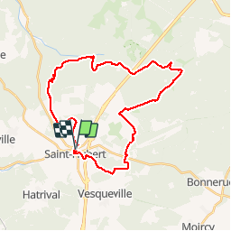
Tour Wandern von 31 km verfügbar auf Wallonien, Luxemburg, Saint-Hubert. Diese Tour wird von rvapeldo vorgeschlagen.
Beschreibung
Très belle boucle avec un passage dans la fagne de Borne, la forêt du roi Albert, le parc à gibier avant la descente vers Saint-Hubert. Dénivelés plutôt doux, chemins aisés.
Ort
Land:
Belgium
Region :
Wallonien
Abteilung/Provinz :
Luxemburg
Kommune :
Saint-Hubert
Standort:
Saint-Hubert
Gehen Sie:(Dec)
Gehen Sie:(UTM)
670101 ; 5544403 (31U) N.
Kommentare
Touren in der Umgebung
![Tour Wandern Saint-Hubert - Saint-Hubert - La Borne (SH07) - Photo](https://media.geolcdn.com/t/375/260/ext.jpg?maxdim=2&url=https%3A%2F%2Fservices.sitytrail.com%2FGeolivesWS%2FDownloadMedia.ashx%3FTrailID%3D334588%26Media%3D91d6a6a6-ea9a-437b-8504-44eab9898f8f.JPG)
![Wandern Wandern](https://static1.geolcdn.com/sitytour/trail-icons/101.png)
Saint-Hubert - La Borne (SH07)
Wandern
Schwierig
(9)
Saint-Hubert,
Wallonien,
Luxemburg,
Belgium
![](/images/other/stat-length.png)
13,9 km | 17,6 km-effort
3h 47min
![](https://static1.geolcdn.com/siteimages/upload/files/16400158638029165_repeat_loop_refresh_sync_direction_icon.png)
Ja
![Tour Wandern Saint-Hubert - Hatrival - Banalbois (SH13) - Photo](https://media.geolcdn.com/t/375/260/ext.jpg?maxdim=2&url=https%3A%2F%2Fservices.sitytrail.com%2FGeolivesWS%2FDownloadMedia.ashx%3FTrailID%3D334467%26Media%3D16828998-416a-43a0-960f-95ce479e5d6d.jpg)
![Wandern Wandern](https://static1.geolcdn.com/sitytour/trail-icons/101.png)
Hatrival - Banalbois (SH13)
Wandern
Medium
(6)
Saint-Hubert,
Wallonien,
Luxemburg,
Belgium
![](/images/other/stat-length.png)
7,5 km | 9,5 km-effort
2h 2min
![](https://static1.geolcdn.com/siteimages/upload/files/16400158638029165_repeat_loop_refresh_sync_direction_icon.png)
Ja
![Wandern Wandern](https://static1.geolcdn.com/sitytour/trail-icons/101.png)
RB-Lu-26_Saint-Hubert_via-racc-1-et-2
Wandern
Sehr leicht
(8)
Saint-Hubert,
Wallonien,
Luxemburg,
Belgium
![](/images/other/stat-length.png)
14,6 km | 19,5 km-effort
4h 15min
![](https://static1.geolcdn.com/siteimages/upload/files/16400158638029165_repeat_loop_refresh_sync_direction_icon.png)
Ja
![Tour Wandern Saint-Hubert - Vesqueville - Vesqueville (SH09) - Photo](https://media.geolcdn.com/t/375/260/ext.jpg?maxdim=2&url=https%3A%2F%2Fservices.sitytrail.com%2FGeolivesWS%2FDownloadMedia.ashx%3FTrailID%3D334610%26Media%3D79c980a9-bd48-4f1e-9150-6b805f1400ff.jpg)
![Wandern Wandern](https://static1.geolcdn.com/sitytour/trail-icons/101.png)
Vesqueville - Vesqueville (SH09)
Wandern
Schwierig
(6)
Saint-Hubert,
Wallonien,
Luxemburg,
Belgium
![](/images/other/stat-length.png)
15,6 km | 19,4 km-effort
4h 9min
![](https://static1.geolcdn.com/siteimages/upload/files/16400158638029165_repeat_loop_refresh_sync_direction_icon.png)
Ja
![Tour Wandern Saint-Hubert - Saint-Hubert - Les Abanages (SH03) - Photo](https://media.geolcdn.com/t/375/260/ext.jpg?maxdim=2&url=https%3A%2F%2Fservices.sitytrail.com%2FGeolivesWS%2FDownloadMedia.ashx%3FTrailID%3D334550%26Media%3D8af2823f-59d0-452e-b66b-4a477ca4facd.JPG)
![Wandern Wandern](https://static1.geolcdn.com/sitytour/trail-icons/101.png)
Saint-Hubert - Les Abanages (SH03)
Wandern
Schwierig
(13)
Saint-Hubert,
Wallonien,
Luxemburg,
Belgium
![](/images/other/stat-length.png)
9,8 km | 13,1 km-effort
2h 49min
![](https://static1.geolcdn.com/siteimages/upload/files/16400158638029165_repeat_loop_refresh_sync_direction_icon.png)
Ja
![Tour Wandern Saint-Hubert - Saint-Hubert - Les Gottes (SH02) - Photo](https://media.geolcdn.com/t/375/260/ext.jpg?maxdim=2&url=https%3A%2F%2Fservices.sitytrail.com%2FGeolivesWS%2FDownloadMedia.ashx%3FTrailID%3D334532%26Media%3D483dd5de-c3cc-4d3d-acb4-87fceee0aac0.JPG)
![Wandern Wandern](https://static1.geolcdn.com/sitytour/trail-icons/101.png)
Saint-Hubert - Les Gottes (SH02)
Wandern
Medium
(17)
Saint-Hubert,
Wallonien,
Luxemburg,
Belgium
![](/images/other/stat-length.png)
6,9 km | 8,6 km-effort
1h 52min
![](https://static1.geolcdn.com/siteimages/upload/files/16400158638029165_repeat_loop_refresh_sync_direction_icon.png)
Ja
![Tour Wandern Saint-Hubert - Marche ADEPS Arville - Photo](https://media.geolcdn.com/t/375/260/3bbd3001-2495-4fe0-a9c1-b38774f0038e.jpg&format=jpg&maxdim=2)
![Wandern Wandern](https://static1.geolcdn.com/sitytour/trail-icons/101.png)
Marche ADEPS Arville
Wandern
Medium
(1)
Saint-Hubert,
Wallonien,
Luxemburg,
Belgium
![](/images/other/stat-length.png)
10,2 km | 13,6 km-effort
2h 13min
![](https://static1.geolcdn.com/siteimages/upload/files/16400158638029165_repeat_loop_refresh_sync_direction_icon.png)
Ja
![Tour Wandern Saint-Hubert - ADEPS Saint Hubert - Photo](https://media.geolcdn.com/t/375/260/018b420c-08b1-4fdb-919c-55acbcd603df.jpg&format=jpg&maxdim=2)
![Wandern Wandern](https://static1.geolcdn.com/sitytour/trail-icons/101.png)
ADEPS Saint Hubert
Wandern
Schwierig
(1)
Saint-Hubert,
Wallonien,
Luxemburg,
Belgium
![](/images/other/stat-length.png)
10,8 km | 13,7 km-effort
1h 57min
![](https://static1.geolcdn.com/siteimages/upload/files/16400158638029165_repeat_loop_refresh_sync_direction_icon.png)
Ja
![Wandern Wandern](https://static1.geolcdn.com/sitytour/trail-icons/101.png)
RB-Lu-26_Saint-Hubert
Wandern
Sehr leicht
(7)
Saint-Hubert,
Wallonien,
Luxemburg,
Belgium
![](/images/other/stat-length.png)
25 km | 33 km-effort
7h 2min
![](https://static1.geolcdn.com/siteimages/upload/files/16400158638029165_repeat_loop_refresh_sync_direction_icon.png)
Ja