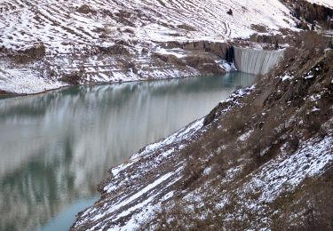
Tour Wandern Bourg-Saint-Pierre - Pointe des planards - Photo
 verbier
verbier

Benutzer

© OpenStreetMap contributors
Länge
Länge
8,4 km
Maximale Höhe
Maximale Höhe
2837 m
Positive Höhendifferenz
1134 m
Km-Effort
Km-Effort  
19,8 km
Min. Höhe
Min. Höhe
1731 m
Negative Höhendifferenz
40 m
Boucle
Boucle
Nein
Erstellungsdatum :
2014-12-10 00:00:00.0
Letzte Änderung :
2014-12-10 00:00:00.0

(0 Nachricht)

Wandern
Wandern
3h27
Schwierigkeit : Unbekannt

Scannen Sie diesen QR-Code, um die Tour in der SityTrail-Anwendung zu öffnen

Kostenlosegpshiking-Anwendung

Logo SityTrail SityTrail

IGN / Geografische Institute

SityTrail aus dem App Store herunterladen SityTrail von Google Play herunterladen

Logo SityTrail SityTrail World

Die Welt öffnet sich für Sie

SityTrail aus dem App Store herunterladen SityTrail von Google Play herunterladen SityTrail auf Huawei AppGallery herunterladen

Über SityTrail

Tour Wandern von 8,4 km verfügbar auf Wallis, Entremont, Bourg-Saint-Pierre. Diese Tour wird von verbier vorgeschlagen.

Beschreibung

At the departure point of the Toules dam, take a suitable way for motor vehicles, which goes up to the top of the dam wall.  Go on above the high mountain pasture “La Lettaz”. The path goes on the top of the pasture called “Fournoutze”, then through several small lakes as far as the “Gouille du Dragon” lake, which is the biggest water place of the area. From the “Gouille du Dragon”, the last section on the ridge will take you to the Pointe des Planards, for a magnificent sightseeing view on the Combe de l’A.

Höhenprofil

POIs

POI Bourg-Saint-Pierre -  Pointe des planards  - Photo
verbier
BOURG-SAINT-PIERRE 
POI Bourg-Saint-Pierre - Barrage des Toules - Photo
verbier
BOURG-SAINT-PIERRE 
POI Bourg-Saint-Pierre - Gouille du dragon - Photo
verbier
BOURG-SAINT-PIERRE 

Ort

Land:
Switzerland
Region :
Wallis
Abteilung/Provinz :
Entremont
Kommune :
Bourg-Saint-Pierre
Standort:
Unknown
Gehen Sie:(Dec)
Gehen Sie:(UTM)
360574 ; 5087619 (32T) N.

Touren in der Umgebung

Tour Zu Fuß Bourg-Saint-Pierre - Tour du Lac des Toules - Photo
Zu Fuß
GUIDE+

Zu Fuß

Medium
Bourg-Saint-Pierre, Wallis, Entremont, Switzerland
14,4 km | 25 km-effort
5h 44min
Ja
Tour Skiwanderen Bourg-Saint-Pierre - col du Grand st Bernard  - Photo
Skiwanderen
mdvdr

Skiwanderen

Sehr leicht
Bourg-Saint-Pierre, Wallis, Entremont, Switzerland
5,1 km | 10,5 km-effort
2h 15min
Nein
Tour Wandern Bourg-Saint-Pierre - Tour des Combins - Photo
Wandern
rpf

Wandern

Sehr leicht
Bourg-Saint-Pierre, Wallis, Entremont, Switzerland
97 km | 180 km-effort
43h 16min
Ja
Tour Wandern Bourg-Saint-Pierre - Bourg-St-Pierre, Cabane du Vélan - Photo
Wandern
rpf

Wandern

Sehr leicht
Bourg-Saint-Pierre, Wallis, Entremont, Switzerland
9,5 km | 19,8 km-effort
5h 30min
Ja
Tour Wandern Bourg-Saint-Pierre - Bourg-St-Pierre, Becca Colinte - Photo
Wandern
rpf

Wandern

Sehr leicht
Bourg-Saint-Pierre, Wallis, Entremont, Switzerland
5 km | 10,5 km-effort
2h 30min
Ja
Tour Schneeschuhwandern Bourg-Saint-Pierre - Bourg-St-Pierre, Sentier Raquettes n° 9, L''Oratoire - Photo
Schneeschuhwandern
verbier

Schneeschuhwandern

Sehr leicht
Bourg-Saint-Pierre, Wallis, Entremont, Switzerland
7,2 km | 9,8 km-effort
3h 0min
Nein
Tour Schneeschuhwandern Bourg-Saint-Pierre - Bourg-St-Pierre, Sentier Raquettes n° 11, Le Guide - Photo
Schneeschuhwandern
verbier

Schneeschuhwandern

Sehr leicht
Bourg-Saint-Pierre, Wallis, Entremont, Switzerland
3,9 km | 5,6 km-effort
1h 20min
Ja
Tour Schneeschuhwandern Bourg-Saint-Pierre - Bourg-St-Pierre, Sentier Raquettes n° 4, La Rare  - Photo
Schneeschuhwandern
verbier

Schneeschuhwandern

Sehr leicht
Bourg-Saint-Pierre, Wallis, Entremont, Switzerland
5 km | 6 km-effort
1h 0min
Nein
Tour Schneeschuhwandern Bourg-Saint-Pierre - Bourg-St-Pierre, Sentier Raquettes n° 5, La Petite Niord - Photo
Schneeschuhwandern
verbier

Schneeschuhwandern

Sehr leicht
Bourg-Saint-Pierre, Wallis, Entremont, Switzerland
9,8 km | 15 km-effort
4h 30min
Nein


Schließen
Meine Abonnements