![](/images/other/stat-length.png)
![Tour Wandern Massegros Causses Gorges - Almières-Le Rozier - Photo](https://media.geolcdn.com/t/1900/400/ext.pjpeg?maxdim=2&url=https%3A%2F%2Fstatic1.geolcdn.com%2Fsiteimages%2Fupload%2Ffiles%2F1553511878bg_sport_marche.png)
Almières-Le Rozier
mozzipsc
Benutzer
![Länge](/images/other/stat-length.png)
Länge
18,5 km
![Maximale Höhe](https://static1.geolcdn.com/siteimages/upload/files/1508320355ic_sort_altitude_max_24dp.png)
Maximale Höhe
914 m
![Positive Höhendifferenz](https://static1.geolcdn.com/siteimages/upload/files/1508320355ic_sort_den_pos_24dp.png)
Positive Höhendifferenz
333 m
![Km-Effort](/images/other/stat-length.png)
Km-Effort
25 km
![Min. Höhe](https://static1.geolcdn.com/siteimages/upload/files/1508320355ic_sort_altitude_min_24dp.png)
Min. Höhe
389 m
![Negative Höhendifferenz](https://static1.geolcdn.com/siteimages/upload/files/1508320355ic_sort_den_neg_24dp.png)
Negative Höhendifferenz
825 m
![Boucle](https://static1.geolcdn.com/siteimages/upload/files/16400158638029165_repeat_loop_refresh_sync_direction_icon.png)
Boucle
Nein
Erstellungsdatum :
2015-06-04 00:00:00.0
Letzte Änderung :
2015-06-04 00:00:00.0
![Wandern](https://static1.geolcdn.com/sitytour/trail-icons/101.png)
5h10
Schwierigkeit : Schwierig
![Scannen Sie diesen QR-Code, um die Tour in der SityTrail-Anwendung zu öffnen](https://capi.geolives.com/qq0zvz2zws4bq2lad0pu/sitytour/trails/429390/qr.png?size=200)
Kostenlosegpshiking-Anwendung
Über SityTrail
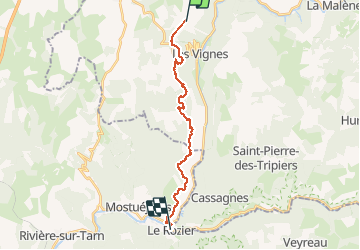
Tour Wandern von 18,5 km verfügbar auf Okzitanien, Lozère, Massegros Causses Gorges. Diese Tour wird von mozzipsc vorgeschlagen.
Beschreibung
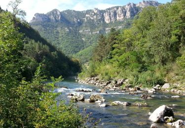
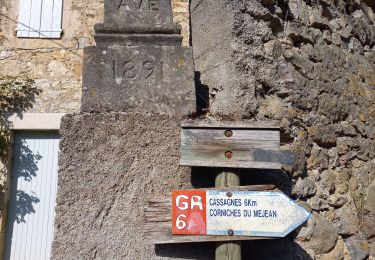
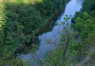
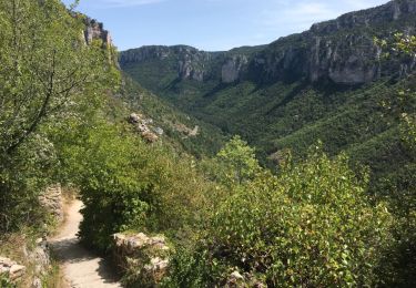
GRp Sauveterre - Bcp plus interessant que le GR6 au bord du Tarn, par ce GRp on se trouve au bord des gorges avec une vue magnifique, aigles et vautours à portée de main !
Traversée de bois et grosse descente sur Rozier.
Ort
Land:
France
Region :
Okzitanien
Abteilung/Provinz :
Lozère
Kommune :
Massegros Causses Gorges
Standort:
Saint-Rome-de-Dolan
Gehen Sie:(Dec)
Gehen Sie:(UTM)
517401 ; 4904583 (31T) N.
Kommentare
Touren in der Umgebung
![Tour Wandern Massegros Causses Gorges - Grands Causses - Gorges du Tarn - Les Vignes - Photo](https://media.geolcdn.com/t/375/260/ext.jpg?maxdim=2&url=https%3A%2F%2Fservices.sitytrail.com%2FGeolivesWS%2FDownloadMedia.ashx%3FTrailID%3D344246%26Media%3Dfix__20140910115908.jpg)
![Wandern Wandern](https://static1.geolcdn.com/sitytour/trail-icons/101.png)
Grands Causses - Gorges du Tarn - Les Vignes
Wandern
Einfach
(1)
Massegros Causses Gorges,
Okzitanien,
Lozère,
France
![](/images/other/stat-length.png)
19 km | 25 km-effort
5h 5min
![](https://static1.geolcdn.com/siteimages/upload/files/16400158638029165_repeat_loop_refresh_sync_direction_icon.png)
Ja
![Tour Wandern Massegros Causses Gorges - GR DE PAYS Causse Mejean et Gorges du Tarn - Photo](https://media.geolcdn.com/t/375/260/efb2823f-4969-4f73-a04b-f5db2dcf4048.jpg&format=jpg&maxdim=2)
![Wandern Wandern](https://static1.geolcdn.com/sitytour/trail-icons/101.png)
GR DE PAYS Causse Mejean et Gorges du Tarn
Wandern
Medium
Massegros Causses Gorges,
Okzitanien,
Lozère,
France
![](/images/other/stat-length.png)
12,4 km | 16,4 km-effort
3h 13min
![](https://static1.geolcdn.com/siteimages/upload/files/16400158638029165_repeat_loop_refresh_sync_direction_icon.png)
Nein
![Tour Nordic Walking Massegros Causses Gorges - Point sublime et tour du Causse de Sauveterre - Photo](https://media.geolcdn.com/t/375/260/f033d6a5-1a5d-4b52-99a8-1b25dd85c5db.jpg&format=jpg&maxdim=2)
![Nordic Walking Nordic Walking](https://static1.geolcdn.com/sitytour/trail-icons/102.png)
Point sublime et tour du Causse de Sauveterre
Nordic Walking
Medium
Massegros Causses Gorges,
Okzitanien,
Lozère,
France
![](/images/other/stat-length.png)
14,9 km | 20 km-effort
4h 56min
![](https://static1.geolcdn.com/siteimages/upload/files/16400158638029165_repeat_loop_refresh_sync_direction_icon.png)
Ja
![Tour Wandern Massegros Causses Gorges - J6: Les Vignes-Mostuéjouls - Photo](https://media.geolcdn.com/t/375/260/38cdeed1-dbeb-493e-97fc-b16032422b0d.jpg&format=jpg&maxdim=2)
![Wandern Wandern](https://static1.geolcdn.com/sitytour/trail-icons/101.png)
J6: Les Vignes-Mostuéjouls
Wandern
Medium
Massegros Causses Gorges,
Okzitanien,
Lozère,
France
![](/images/other/stat-length.png)
15,8 km | 21 km-effort
4h 51min
![](https://static1.geolcdn.com/siteimages/upload/files/16400158638029165_repeat_loop_refresh_sync_direction_icon.png)
Nein
![Tour Wandern Massegros Causses Gorges - Le Massegros, Point Sublime, Soulages - Photo](https://media.geolcdn.com/t/375/260/ext.jpg?maxdim=2&url=https%3A%2F%2Fservices.sitytrail.com%2FGeolivesWS%2FDownloadMedia.ashx%3FTrailID%3D104994%26Media%3D8557_6.jpg)
![Wandern Wandern](https://static1.geolcdn.com/sitytour/trail-icons/101.png)
Le Massegros, Point Sublime, Soulages
Wandern
Schwierig
Massegros Causses Gorges,
Okzitanien,
Lozère,
France
![](/images/other/stat-length.png)
23 km | 31 km-effort
6h 0min
![](https://static1.geolcdn.com/siteimages/upload/files/16400158638029165_repeat_loop_refresh_sync_direction_icon.png)
Ja
![Tour Kanufahren - Kajakfahren Massegros Causses Gorges - GR6 jour 8 Le Rozier - Photo](https://media.geolcdn.com/t/375/260/9ed4a276-f7c4-4a6a-b8e0-54ddbc0ac77b.jpg&format=jpg&maxdim=2)
![Kanufahren - Kajakfahren Kanufahren - Kajakfahren](https://static1.geolcdn.com/sitytour/trail-icons/703.png)
GR6 jour 8 Le Rozier
Kanufahren - Kajakfahren
Sehr leicht
Massegros Causses Gorges,
Okzitanien,
Lozère,
France
![](/images/other/stat-length.png)
12,7 km | 14,4 km-effort
5h 54min
![](https://static1.geolcdn.com/siteimages/upload/files/16400158638029165_repeat_loop_refresh_sync_direction_icon.png)
Nein
![Tour Wandern Massegros Causses Gorges - clauvel /Eglazine/St marcelin - Photo](https://media.geolcdn.com/t/375/260/eeecc672-803f-4bb6-bcc0-7e614c851ac7.jpg&format=jpg&maxdim=2)
![Wandern Wandern](https://static1.geolcdn.com/sitytour/trail-icons/101.png)
clauvel /Eglazine/St marcelin
Wandern
Medium
Massegros Causses Gorges,
Okzitanien,
Lozère,
France
![](/images/other/stat-length.png)
14,1 km | 21 km-effort
5h 23min
![](https://static1.geolcdn.com/siteimages/upload/files/16400158638029165_repeat_loop_refresh_sync_direction_icon.png)
Ja
![Tour sport Massegros Causses Gorges - 2022-04-21_14h46m01_Cirkwi-Voyage_entre_gorges_et_causses_au_pays_des_vautours - Photo](https://media.geolcdn.com/t/375/260/ext.jpg?maxdim=2&url=https%3A%2F%2Fsecurestorage.geolives.com%2Fsitytour%2Ftrail-bg%2Fdefault.jpg)
2022-04-21_14h46m01_Cirkwi-Voyage_entre_gorges_et_causses_au_pays_des_vautours
sport
Sehr leicht
Massegros Causses Gorges,
Okzitanien,
Lozère,
France
![](/images/other/stat-length.png)
50 km | 72 km-effort
Unbekannt
![](https://static1.geolcdn.com/siteimages/upload/files/16400158638029165_repeat_loop_refresh_sync_direction_icon.png)
Ja
![Tour Andere Aktivitäten Massegros Causses Gorges - Atlamed Les Vignes - St Pierre des Tripiers - Photo](https://media.geolcdn.com/t/375/260/ext.jpg?maxdim=2&url=https%3A%2F%2Fservices.sitytrail.com%2FGeolivesWS%2FDownloadMedia.ashx%3FTrailID%3D814306%26Media%3D20170819135905.jpg)
![Andere Aktivitäten Andere Aktivitäten](https://static1.geolcdn.com/sitytour/trail-icons/900.png)
Atlamed Les Vignes - St Pierre des Tripiers
Andere Aktivitäten
Sehr leicht
Massegros Causses Gorges,
Okzitanien,
Lozère,
France
![](/images/other/stat-length.png)
23 km | 34 km-effort
5h 41min
![](https://static1.geolcdn.com/siteimages/upload/files/16400158638029165_repeat_loop_refresh_sync_direction_icon.png)
Nein