![](/images/other/stat-length.png)
![Tour Wandern Comines-Warneton - Le BIZET, la Lys et la zone frontalière version 11km - Photo](https://media.geolcdn.com/t/1900/400/ext.pjpeg?maxdim=2&url=https%3A%2F%2Fstatic1.geolcdn.com%2Fsiteimages%2Fupload%2Ffiles%2F1553511878bg_sport_marche.png)
Le BIZET, la Lys et la zone frontalière version 11km
fif59280
Benutzer
![Länge](/images/other/stat-length.png)
![Maximale Höhe](https://static1.geolcdn.com/siteimages/upload/files/1508320355ic_sort_altitude_max_24dp.png)
![Positive Höhendifferenz](https://static1.geolcdn.com/siteimages/upload/files/1508320355ic_sort_den_pos_24dp.png)
![Km-Effort](/images/other/stat-length.png)
![Min. Höhe](https://static1.geolcdn.com/siteimages/upload/files/1508320355ic_sort_altitude_min_24dp.png)
![Negative Höhendifferenz](https://static1.geolcdn.com/siteimages/upload/files/1508320355ic_sort_den_neg_24dp.png)
![Boucle](https://static1.geolcdn.com/siteimages/upload/files/16400158638029165_repeat_loop_refresh_sync_direction_icon.png)
![Wandern](https://static1.geolcdn.com/sitytour/trail-icons/101.png)
2h37
Schwierigkeit : Medium
![Scannen Sie diesen QR-Code, um die Tour in der SityTrail-Anwendung zu öffnen](https://capi.geolives.com/qq0zvz2zws4bq2lad0pu/sitytour/trails/4280862/qr.png?size=200)
Kostenlosegpshiking-Anwendung
Über SityTrail
Tour Wandern von 10,9 km verfügbar auf Wallonien, Hennegau, Comines-Warneton. Diese Tour wird von fif59280 vorgeschlagen.
Beschreibung
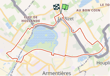
Coordonnées de départ : N 50°42'28.763" E2°53'3,792"
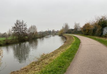
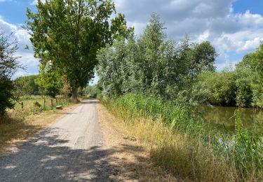
A partir du parking du Bizet, longer la frontière vers le cimetière d'Armentières mais en raison de travaux prendre à gauche avant les abords du cimetière. Arrivé à la Lys, la suivre vers l'ouest jusqu'au nouveau pont proche de l'ancienne brasserie. Suivre ce chemin à droite après avoir franchi le pont et rejoindre le Pont de Nieppe (azimut 25°) puis en longeant la frontière Franco-belge rejoindre le point de départ.
Ort
Kommentare
Touren in der Umgebung
![Tour Wandern Comines-Warneton - Ploegsteert2 - Photo](https://media.geolcdn.com/t/375/260/a18aaf3b-b0bc-4f4e-b927-dc13a3158e1c.jpg&format=jpg&maxdim=2)
![Wandern Wandern](https://static1.geolcdn.com/sitytour/trail-icons/101.png)
Wandern
![](/images/other/stat-length.png)
![](https://static1.geolcdn.com/siteimages/upload/files/16400158638029165_repeat_loop_refresh_sync_direction_icon.png)
![Tour Zu Fuß Heuvelland - Geuzen wandelroute - Photo](https://media.geolcdn.com/t/375/260/a748d58f-6dfe-4ad8-b887-8505015b63cc.jpeg&format=jpg&maxdim=2)
![Zu Fuß Zu Fuß](https://static1.geolcdn.com/sitytour/trail-icons/100.png)
Zu Fuß
![](/images/other/stat-length.png)
![](https://static1.geolcdn.com/siteimages/upload/files/16400158638029165_repeat_loop_refresh_sync_direction_icon.png)
![Tour Wandern Deûlémont - de la base de loisir de Deulemont à Toufflers. - Photo](https://media.geolcdn.com/t/375/260/5ac53abb-339d-4e2a-9cbd-7a169a52403a.jpg&format=jpg&maxdim=2)
![Wandern Wandern](https://static1.geolcdn.com/sitytour/trail-icons/101.png)
Wandern
![](/images/other/stat-length.png)
![](https://static1.geolcdn.com/siteimages/upload/files/16400158638029165_repeat_loop_refresh_sync_direction_icon.png)
![Tour Wandern Frelinghien - Frelinghien 10,9 km - Photo](https://media.geolcdn.com/t/375/260/e9892460-75c9-49f2-9a9a-96bdb62e1fb4.jpg&format=jpg&maxdim=2)
![Wandern Wandern](https://static1.geolcdn.com/sitytour/trail-icons/101.png)
Wandern
![](/images/other/stat-length.png)
![](https://static1.geolcdn.com/siteimages/upload/files/16400158638029165_repeat_loop_refresh_sync_direction_icon.png)
![Tour Wandern Armentières - Armantiere 11 km - Photo](https://media.geolcdn.com/t/375/260/2b4ca994-85f8-4e5f-b7cf-d67b61642113.jpg&format=jpg&maxdim=2)
![Wandern Wandern](https://static1.geolcdn.com/sitytour/trail-icons/101.png)
Wandern
![](/images/other/stat-length.png)
![](https://static1.geolcdn.com/siteimages/upload/files/16400158638029165_repeat_loop_refresh_sync_direction_icon.png)
![Tour Wandern Warneton - Warneton 10,6 km - Photo](https://media.geolcdn.com/t/375/260/f885a358-29e3-4e03-aa6f-0a93c653f8bf.jpg&format=jpg&maxdim=2)
![Wandern Wandern](https://static1.geolcdn.com/sitytour/trail-icons/101.png)
Wandern
![](/images/other/stat-length.png)
![](https://static1.geolcdn.com/siteimages/upload/files/16400158638029165_repeat_loop_refresh_sync_direction_icon.png)
![Tour Wandern Frelinghien - Frelinghien Deule 13 km - Photo](https://media.geolcdn.com/t/375/260/d8d1bfc7-e840-48a0-817e-fbeb606f87c9.jpg&format=jpg&maxdim=2)
![Wandern Wandern](https://static1.geolcdn.com/sitytour/trail-icons/101.png)
Wandern
![](/images/other/stat-length.png)
![](https://static1.geolcdn.com/siteimages/upload/files/16400158638029165_repeat_loop_refresh_sync_direction_icon.png)
![Tour Wandern Heuvelland - Nieuwekerke Bailleul 17,5 km - Photo](https://media.geolcdn.com/t/375/260/9e8e5b67-08f2-434d-8359-01cf5462426a.jpg&format=jpg&maxdim=2)
![Wandern Wandern](https://static1.geolcdn.com/sitytour/trail-icons/101.png)
Wandern
![](/images/other/stat-length.png)
![](https://static1.geolcdn.com/siteimages/upload/files/16400158638029165_repeat_loop_refresh_sync_direction_icon.png)
![Tour Wandern Armentières - Au fil de l''eau - Armentières - Photo](https://media.geolcdn.com/t/375/260/ext.jpg?maxdim=2&url=https%3A%2F%2Fservices.sitytrail.com%2FGeolivesWS%2FDownloadMedia.ashx%3FTrailID%3D215297%26Media%3D15829_6.jpg)
![Wandern Wandern](https://static1.geolcdn.com/sitytour/trail-icons/101.png)
Wandern
![](/images/other/stat-length.png)
![](https://static1.geolcdn.com/siteimages/upload/files/16400158638029165_repeat_loop_refresh_sync_direction_icon.png)