![](/images/other/stat-length.png)
![Tour Wandern Prunet-et-Belpuig - BOULE d'AMONT - La TRINITE - Photo](https://media.geolcdn.com/t/1900/400/63148342-eaf9-42f9-af5b-21ab9e845710.jpg&format=pjpeg&maxdim=2)
BOULE d'AMONT - La TRINITE
MarcOBRECHT
Benutzer
![Länge](/images/other/stat-length.png)
Länge
12,4 km
![Maximale Höhe](https://static1.geolcdn.com/siteimages/upload/files/1508320355ic_sort_altitude_max_24dp.png)
Maximale Höhe
686 m
![Positive Höhendifferenz](https://static1.geolcdn.com/siteimages/upload/files/1508320355ic_sort_den_pos_24dp.png)
Positive Höhendifferenz
348 m
![Km-Effort](/images/other/stat-length.png)
Km-Effort
17 km
![Min. Höhe](https://static1.geolcdn.com/siteimages/upload/files/1508320355ic_sort_altitude_min_24dp.png)
Min. Höhe
408 m
![Negative Höhendifferenz](https://static1.geolcdn.com/siteimages/upload/files/1508320355ic_sort_den_neg_24dp.png)
Negative Höhendifferenz
349 m
![Boucle](https://static1.geolcdn.com/siteimages/upload/files/16400158638029165_repeat_loop_refresh_sync_direction_icon.png)
Boucle
Ja
Erstellungsdatum :
2024-11-21 09:19:37.689
Letzte Änderung :
2024-11-23 22:04:10.391
![Wandern](https://static1.geolcdn.com/sitytour/trail-icons/101.png)
3h20
Schwierigkeit : Medium
![Scannen Sie diesen QR-Code, um die Tour in der SityTrail-Anwendung zu öffnen](https://capi.geolives.com/qq0zvz2zws4bq2lad0pu/sitytour/trails/4276879/qr.png?size=200)
Kostenlosegpshiking-Anwendung
Über SityTrail
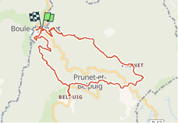
Tour Wandern von 12,4 km verfügbar auf Okzitanien, Ostpyrenäen, Prunet-et-Belpuig. Diese Tour wird von MarcOBRECHT vorgeschlagen.
Beschreibung
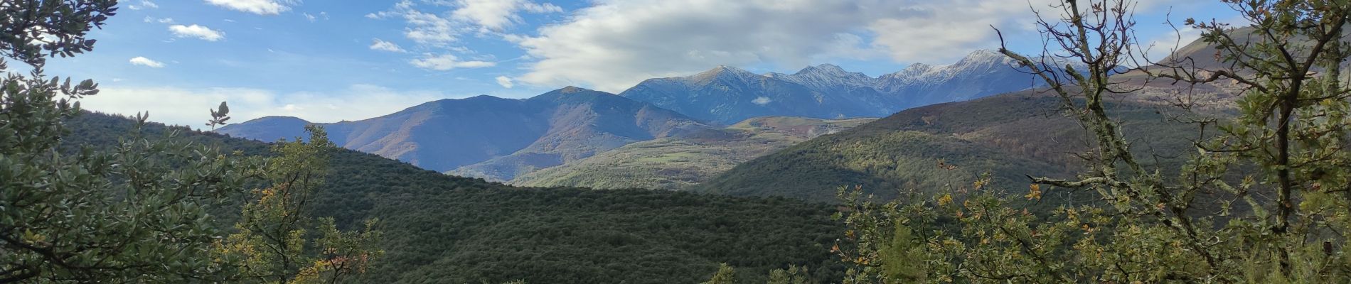
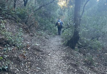
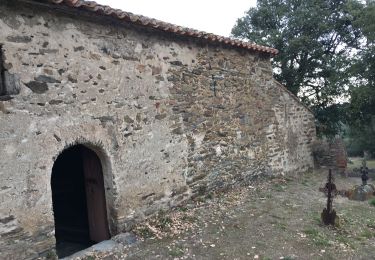
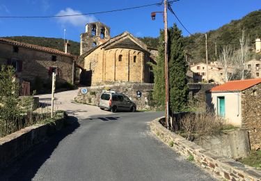
Depuis boule d'amont en montant vers la chapelle de Prunet.
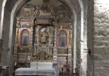
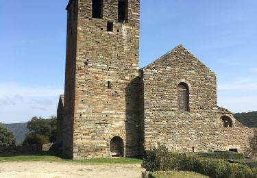
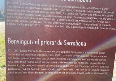
Direction la Trinité puis montée aux ruines du chateau et visite de l'église.
Descente et retour
Ort
Land:
France
Region :
Okzitanien
Abteilung/Provinz :
Ostpyrenäen
Kommune :
Prunet-et-Belpuig
Standort:
Unknown
Gehen Sie:(Dec)
Gehen Sie:(UTM)
468496 ; 4714212 (31T) N.
Kommentare
Touren in der Umgebung
![Tour Wandern Casefabre - Casefabre 66 - Photo](https://media.geolcdn.com/t/375/260/fda5b463-42b5-4e8b-9ebd-458b38a5ec57.jpg&format=jpg&maxdim=2)
![Wandern Wandern](https://static1.geolcdn.com/sitytour/trail-icons/101.png)
Casefabre 66
Wandern
Medium
Casefabre,
Okzitanien,
Ostpyrenäen,
France
![](/images/other/stat-length.png)
10,4 km | 14,8 km-effort
3h 19min
![](https://static1.geolcdn.com/siteimages/upload/files/16400158638029165_repeat_loop_refresh_sync_direction_icon.png)
Ja
![Tour Wandern Prunet-et-Belpuig - Boule d’amont /Chapelle de la Trinité / Prunet - Photo](https://media.geolcdn.com/t/375/260/68eed7a9-ae13-40d7-8c91-a7b1707b93bf.jpg&format=jpg&maxdim=2)
![Wandern Wandern](https://static1.geolcdn.com/sitytour/trail-icons/101.png)
Boule d’amont /Chapelle de la Trinité / Prunet
Wandern
Einfach
Prunet-et-Belpuig,
Okzitanien,
Ostpyrenäen,
France
![](/images/other/stat-length.png)
11,2 km | 16 km-effort
3h 6min
![](https://static1.geolcdn.com/siteimages/upload/files/16400158638029165_repeat_loop_refresh_sync_direction_icon.png)
Ja
![Tour Wandern Boule-d'Amont - 20240104 Tour depuis le prieuré de Serrabonne - Photo](https://media.geolcdn.com/t/375/260/a082747f-89ab-4e46-8caf-fd728589230f.jpg&format=jpg&maxdim=2)
![Wandern Wandern](https://static1.geolcdn.com/sitytour/trail-icons/101.png)
20240104 Tour depuis le prieuré de Serrabonne
Wandern
Medium
Boule-d'Amont,
Okzitanien,
Ostpyrenäen,
France
![](/images/other/stat-length.png)
15,2 km | 26 km-effort
4h 37min
![](https://static1.geolcdn.com/siteimages/upload/files/16400158638029165_repeat_loop_refresh_sync_direction_icon.png)
Ja
![Tour Wandern Boule-d'Amont - Serrabone /le roc rouge(le rocher du dragon):itinéraire 2 - Photo](https://media.geolcdn.com/t/375/260/26b43676-9e75-4b0d-befc-d44645d8fbe1.jpg&format=jpg&maxdim=2)
![Wandern Wandern](https://static1.geolcdn.com/sitytour/trail-icons/101.png)
Serrabone /le roc rouge(le rocher du dragon):itinéraire 2
Wandern
Medium
Boule-d'Amont,
Okzitanien,
Ostpyrenäen,
France
![](/images/other/stat-length.png)
10,1 km | 17,5 km-effort
3h 32min
![](https://static1.geolcdn.com/siteimages/upload/files/16400158638029165_repeat_loop_refresh_sync_direction_icon.png)
Ja
![Tour Wandern Boule-d'Amont - Serra une - Photo](https://media.geolcdn.com/t/375/260/40936afc-9b58-415d-9be4-e3356895329e.jpg&format=jpg&maxdim=2)
![Wandern Wandern](https://static1.geolcdn.com/sitytour/trail-icons/101.png)
Serra une
Wandern
Medium
Boule-d'Amont,
Okzitanien,
Ostpyrenäen,
France
![](/images/other/stat-length.png)
10,4 km | 17,8 km-effort
3h 44min
![](https://static1.geolcdn.com/siteimages/upload/files/16400158638029165_repeat_loop_refresh_sync_direction_icon.png)
Ja
![Tour Wandern Boule-d'Amont - 20210321 Boule d’Amont - Serrabone - Photo](https://media.geolcdn.com/t/375/260/16b44598-e6b8-4fe8-87e4-5112a1cd140b.jpg&format=jpg&maxdim=2)
![Wandern Wandern](https://static1.geolcdn.com/sitytour/trail-icons/101.png)
20210321 Boule d’Amont - Serrabone
Wandern
Medium
Boule-d'Amont,
Okzitanien,
Ostpyrenäen,
France
![](/images/other/stat-length.png)
13,4 km | 23 km-effort
3h 58min
![](https://static1.geolcdn.com/siteimages/upload/files/16400158638029165_repeat_loop_refresh_sync_direction_icon.png)
Ja
![Tour Wandern Boule-d'Amont - Serrabonne autour du prieuré - Photo](https://media.geolcdn.com/t/375/260/24231eed-2f48-4061-8c52-7dd0f6f55a72.jpg&format=jpg&maxdim=2)
![Wandern Wandern](https://static1.geolcdn.com/sitytour/trail-icons/101.png)
Serrabonne autour du prieuré
Wandern
Medium
Boule-d'Amont,
Okzitanien,
Ostpyrenäen,
France
![](/images/other/stat-length.png)
9,3 km | 16,2 km-effort
4h 27min
![](https://static1.geolcdn.com/siteimages/upload/files/16400158638029165_repeat_loop_refresh_sync_direction_icon.png)
Ja
![Tour Wandern Caixas - Fontcouverte 3 chapelles - Photo](https://media.geolcdn.com/t/375/260/af49db35-9ffa-47e6-b836-be8e544cfc79.jpg&format=jpg&maxdim=2)
![Wandern Wandern](https://static1.geolcdn.com/sitytour/trail-icons/101.png)
Fontcouverte 3 chapelles
Wandern
Schwierig
Caixas,
Okzitanien,
Ostpyrenäen,
France
![](/images/other/stat-length.png)
28 km | 38 km-effort
3h 46min
![](https://static1.geolcdn.com/siteimages/upload/files/16400158638029165_repeat_loop_refresh_sync_direction_icon.png)
Nein
![Tour Wandern Prunet-et-Belpuig - Boule d’amont Prunet-et-Belpuig la Trinité - Photo](https://media.geolcdn.com/t/375/260/a989c071-b899-4092-a76b-68c708add189.jpg&format=jpg&maxdim=2)
![Wandern Wandern](https://static1.geolcdn.com/sitytour/trail-icons/101.png)
Boule d’amont Prunet-et-Belpuig la Trinité
Wandern
Schwierig
Prunet-et-Belpuig,
Okzitanien,
Ostpyrenäen,
France
![](/images/other/stat-length.png)
13,7 km | 19,4 km-effort
3h 25min
![](https://static1.geolcdn.com/siteimages/upload/files/16400158638029165_repeat_loop_refresh_sync_direction_icon.png)
Ja