![](/images/other/stat-length.png)
![Tour Wandern Héry - Sougère Héry - Photo](https://media.geolcdn.com/t/1900/400/ext.pjpeg?maxdim=2&url=https%3A%2F%2Fstatic1.geolcdn.com%2Fsiteimages%2Fupload%2Ffiles%2F1553511878bg_sport_marche.png)
Sougère Héry
JMC89
Benutzer
![Länge](/images/other/stat-length.png)
Länge
8,3 km
![Maximale Höhe](https://static1.geolcdn.com/siteimages/upload/files/1508320355ic_sort_altitude_max_24dp.png)
Maximale Höhe
173 m
![Positive Höhendifferenz](https://static1.geolcdn.com/siteimages/upload/files/1508320355ic_sort_den_pos_24dp.png)
Positive Höhendifferenz
82 m
![Km-Effort](/images/other/stat-length.png)
Km-Effort
9,4 km
![Min. Höhe](https://static1.geolcdn.com/siteimages/upload/files/1508320355ic_sort_altitude_min_24dp.png)
Min. Höhe
118 m
![Negative Höhendifferenz](https://static1.geolcdn.com/siteimages/upload/files/1508320355ic_sort_den_neg_24dp.png)
Negative Höhendifferenz
79 m
![Boucle](https://static1.geolcdn.com/siteimages/upload/files/16400158638029165_repeat_loop_refresh_sync_direction_icon.png)
Boucle
Ja
Erstellungsdatum :
2024-11-11 15:40:39.301
Letzte Änderung :
2024-11-11 16:55:49.985
![Wandern](https://static1.geolcdn.com/sitytour/trail-icons/101.png)
2h07
Schwierigkeit : Medium
![Scannen Sie diesen QR-Code, um die Tour in der SityTrail-Anwendung zu öffnen](https://capi.geolives.com/qq0zvz2zws4bq2lad0pu/sitytour/trails/4261768/qr.png?size=200)
Kostenlosegpshiking-Anwendung
Über SityTrail
Tour Wandern von 8,3 km verfügbar auf Burgund und Freigrafschaft, Yonne, Héry. Diese Tour wird von JMC89 vorgeschlagen.
Beschreibung
Départ du Parking de la Grande Allée à 1 km de Sougère sur Sinotte, direction ouest, remontée vers Héry et redescente par l'est du bois pour rattraper la grande allée.
Ort
Land:
France
Region :
Burgund und Freigrafschaft
Abteilung/Provinz :
Yonne
Kommune :
Héry
Standort:
Unknown
Gehen Sie:(Dec)
Gehen Sie:(UTM)
546977 ; 5302583 (31T) N.
Kommentare
Touren in der Umgebung
![Tour Wandern Montigny-la-Resle - Randonnée Montigny la Resle - Photo](https://media.geolcdn.com/t/375/260/1f607010-ae8f-40b5-959b-769cec615d7a.jpg&format=jpg&maxdim=2)
![Wandern Wandern](https://static1.geolcdn.com/sitytour/trail-icons/101.png)
Randonnée Montigny la Resle
Wandern
Einfach
Montigny-la-Resle,
Burgund und Freigrafschaft,
Yonne,
France
![](/images/other/stat-length.png)
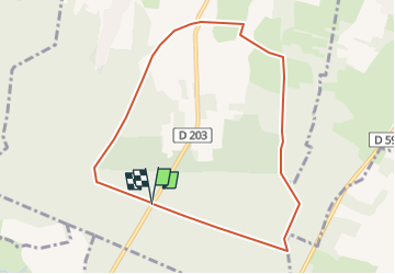
12,4 km | 14,5 km-effort
2h 54min
![](https://static1.geolcdn.com/siteimages/upload/files/16400158638029165_repeat_loop_refresh_sync_direction_icon.png)
Ja
![Tour Wandern Montigny-la-Resle - ZB9 et ZB10 - Bornage 1728 - 13022024 - Photo](https://media.geolcdn.com/t/375/260/73aa85f0-a874-4032-9b16-848bef49981d.jpg&format=jpg&maxdim=2)
![Wandern Wandern](https://static1.geolcdn.com/sitytour/trail-icons/101.png)
ZB9 et ZB10 - Bornage 1728 - 13022024
Wandern
Einfach
Montigny-la-Resle,
Burgund und Freigrafschaft,
Yonne,
France
![](/images/other/stat-length.png)
2,6 km | 3,1 km-effort
42min
![](https://static1.geolcdn.com/siteimages/upload/files/16400158638029165_repeat_loop_refresh_sync_direction_icon.png)
Ja
![Tour Wandern Monéteau - Monéteau le petit Pien - le Grand Pien - Photo](https://media.geolcdn.com/t/375/260/ext.jpg?maxdim=2&url=https%3A%2F%2Fstatic1.geolcdn.com%2Fsiteimages%2Fupload%2Ffiles%2F1553511878bg_sport_marche.png)
![Wandern Wandern](https://static1.geolcdn.com/sitytour/trail-icons/101.png)
Monéteau le petit Pien - le Grand Pien
Wandern
Medium
Monéteau,
Burgund und Freigrafschaft,
Yonne,
France
![](/images/other/stat-length.png)
7,7 km | 9,1 km-effort
2h 4min
![](https://static1.geolcdn.com/siteimages/upload/files/16400158638029165_repeat_loop_refresh_sync_direction_icon.png)
Ja
![Tour Wandern Vergigny - ZC 18 - Borne 250624 - Photo](https://media.geolcdn.com/t/375/260/661ebb77-f694-42ee-bd18-cc3e3a277366.jpg&format=jpg&maxdim=2)
![Wandern Wandern](https://static1.geolcdn.com/sitytour/trail-icons/101.png)
ZC 18 - Borne 250624
Wandern
Einfach
Vergigny,
Burgund und Freigrafschaft,
Yonne,
France
![](/images/other/stat-length.png)
905 m | 965 m-effort
19min
![](https://static1.geolcdn.com/siteimages/upload/files/16400158638029165_repeat_loop_refresh_sync_direction_icon.png)
Nein
![Tour Wandern Rouvray - Borne ZB13 - Photo](https://media.geolcdn.com/t/375/260/fe8a09f5-0312-4202-a609-6f832137858f.jpg&format=jpg&maxdim=2)
![Wandern Wandern](https://static1.geolcdn.com/sitytour/trail-icons/101.png)
Borne ZB13
Wandern
Einfach
Rouvray,
Burgund und Freigrafschaft,
Yonne,
France
![](/images/other/stat-length.png)
440 m | 496 m-effort
22min
![](https://static1.geolcdn.com/siteimages/upload/files/16400158638029165_repeat_loop_refresh_sync_direction_icon.png)
Ja
![Tour Wandern Venouse - 200224-Bornes NON trouvées - Photo](https://media.geolcdn.com/t/375/260/06ee59ee-9a8f-4635-8a45-b2b505f04eac.jpg&format=jpg&maxdim=2)
![Wandern Wandern](https://static1.geolcdn.com/sitytour/trail-icons/101.png)
200224-Bornes NON trouvées
Wandern
Einfach
Venouse,
Burgund und Freigrafschaft,
Yonne,
France
![](/images/other/stat-length.png)
1,6 km | 1,8 km-effort
42min
![](https://static1.geolcdn.com/siteimages/upload/files/16400158638029165_repeat_loop_refresh_sync_direction_icon.png)
Ja
![Tour Zu Fuß Monéteau - le Grand Pien - Photo](https://media.geolcdn.com/t/375/260/ext.jpg?maxdim=2&url=https%3A%2F%2Fstatic1.geolcdn.com%2Fsiteimages%2Fupload%2Ffiles%2F1545311037marcheuse_200dpi.jpg)
![Zu Fuß Zu Fuß](https://static1.geolcdn.com/sitytour/trail-icons/100.png)
le Grand Pien
Zu Fuß
Einfach
Monéteau,
Burgund und Freigrafschaft,
Yonne,
France
![](/images/other/stat-length.png)
8,6 km | 10,2 km-effort
2h 19min
![](https://static1.geolcdn.com/siteimages/upload/files/16400158638029165_repeat_loop_refresh_sync_direction_icon.png)
Ja
![Tour Zu Fuß Monéteau - Monéteau Gurgy - Photo](https://media.geolcdn.com/t/375/260/ext.jpg?maxdim=2&url=https%3A%2F%2Fstatic1.geolcdn.com%2Fsiteimages%2Fupload%2Ffiles%2F1545311037marcheuse_200dpi.jpg)
![Zu Fuß Zu Fuß](https://static1.geolcdn.com/sitytour/trail-icons/100.png)
Monéteau Gurgy
Zu Fuß
Einfach
Monéteau,
Burgund und Freigrafschaft,
Yonne,
France
![](/images/other/stat-length.png)
8,9 km | 9,8 km-effort
2h 13min
![](https://static1.geolcdn.com/siteimages/upload/files/16400158638029165_repeat_loop_refresh_sync_direction_icon.png)
Ja
![Tour Wandern Villeneuve-Saint-Salves - Villeneuve St salve - Photo](https://media.geolcdn.com/t/375/260/ext.jpg?maxdim=2&url=https%3A%2F%2Fstatic1.geolcdn.com%2Fsiteimages%2Fupload%2Ffiles%2F1553511878bg_sport_marche.png)
![Wandern Wandern](https://static1.geolcdn.com/sitytour/trail-icons/101.png)
Villeneuve St salve
Wandern
Medium
Villeneuve-Saint-Salves,
Burgund und Freigrafschaft,
Yonne,
France
![](/images/other/stat-length.png)
8,4 km | 10,2 km-effort
2h 17min
![](https://static1.geolcdn.com/siteimages/upload/files/16400158638029165_repeat_loop_refresh_sync_direction_icon.png)
Ja