![](/images/other/stat-length.png)
![Tour Wandern Ballancourt-sur-Essonne - Rando Ballancourt 15 km BM - Photo](https://media.geolcdn.com/t/1900/400/8977c33c-1145-4a4f-97a7-a064e00deb0b.jpg&format=pjpeg&maxdim=2)
Rando Ballancourt 15 km BM
jeanmarcMasson
Benutzer GUIDE
![Länge](/images/other/stat-length.png)
Länge
14,8 km
![Maximale Höhe](https://static1.geolcdn.com/siteimages/upload/files/1508320355ic_sort_altitude_max_24dp.png)
Maximale Höhe
151 m
![Positive Höhendifferenz](https://static1.geolcdn.com/siteimages/upload/files/1508320355ic_sort_den_pos_24dp.png)
Positive Höhendifferenz
152 m
![Km-Effort](/images/other/stat-length.png)
Km-Effort
16,9 km
![Min. Höhe](https://static1.geolcdn.com/siteimages/upload/files/1508320355ic_sort_altitude_min_24dp.png)
Min. Höhe
47 m
![Negative Höhendifferenz](https://static1.geolcdn.com/siteimages/upload/files/1508320355ic_sort_den_neg_24dp.png)
Negative Höhendifferenz
152 m
![Boucle](https://static1.geolcdn.com/siteimages/upload/files/16400158638029165_repeat_loop_refresh_sync_direction_icon.png)
Boucle
Ja
Erstellungsdatum :
2024-11-03 09:11:36.433
Letzte Änderung :
2024-11-12 21:20:50.695
![Wandern](https://static1.geolcdn.com/sitytour/trail-icons/101.png)
3h50
Schwierigkeit : Schwierig
![Scannen Sie diesen QR-Code, um die Tour in der SityTrail-Anwendung zu öffnen](https://capi.geolives.com/qq0zvz2zws4bq2lad0pu/sitytour/trails/4246073/qr.png?size=200)
Kostenlosegpshiking-Anwendung
Über SityTrail
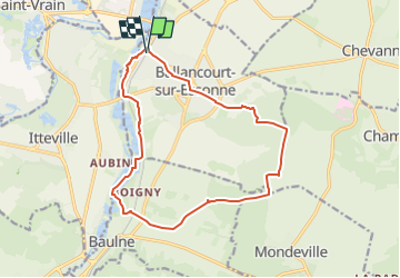
Tour Wandern von 14,8 km verfügbar auf Île-de-France, Essonne, Ballancourt-sur-Essonne. Diese Tour wird von jeanmarcMasson vorgeschlagen.
Beschreibung
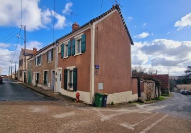
Départ de la gare de Ballancourt
Pique-Nique dans cabane de chasseurs à 7,5 km
Passage auprès des Roches du Père la Musique à environ 12 km
Ort
Land:
France
Region :
Île-de-France
Abteilung/Provinz :
Essonne
Kommune :
Ballancourt-sur-Essonne
Standort:
Unknown
Gehen Sie:(Dec)
Gehen Sie:(UTM)
453580 ; 5375602 (31U) N.
Kommentare
Touren in der Umgebung
![Tour Wandern Écharcon - Autour de Vert le Petit - Photo](https://media.geolcdn.com/t/375/260/ext.jpg?maxdim=2&url=https%3A%2F%2Fservices.sitytrail.com%2FGeolivesWS%2FDownloadMedia.ashx%3FTrailID%3D102739%26Media%3D3871_4.jpg)
![Wandern Wandern](https://static1.geolcdn.com/sitytour/trail-icons/101.png)
Autour de Vert le Petit
Wandern
Medium
(1)
Écharcon,
Île-de-France,
Essonne,
France
![](/images/other/stat-length.png)
16 km | 17,9 km-effort
4h 0min
![](https://static1.geolcdn.com/siteimages/upload/files/16400158638029165_repeat_loop_refresh_sync_direction_icon.png)
Ja
![Tour Wandern Itteville - Les vieilles ailes - Photo](https://media.geolcdn.com/t/375/260/401f9abb-572c-45de-a602-03e6caf0f1c1.jpg&format=jpg&maxdim=2)
![Wandern Wandern](https://static1.geolcdn.com/sitytour/trail-icons/101.png)
Les vieilles ailes
Wandern
Einfach
(1)
Itteville,
Île-de-France,
Essonne,
France
![](/images/other/stat-length.png)
16,8 km | 19,2 km-effort
3h 37min
![](https://static1.geolcdn.com/siteimages/upload/files/16400158638029165_repeat_loop_refresh_sync_direction_icon.png)
Ja
![Tour Zu Fuß Mennecy - Boucle 20 km autour de Mennecy - Photo](https://media.geolcdn.com/t/375/260/a0d84bba-b7da-4081-b724-5ae5c2d178d5.jpg&format=jpg&maxdim=2)
![Zu Fuß Zu Fuß](https://static1.geolcdn.com/sitytour/trail-icons/100.png)
Boucle 20 km autour de Mennecy
Zu Fuß
Medium
Mennecy,
Île-de-France,
Essonne,
France
![](/images/other/stat-length.png)
20 km | 23 km-effort
5h 15min
![](https://static1.geolcdn.com/siteimages/upload/files/16400158638029165_repeat_loop_refresh_sync_direction_icon.png)
Ja
![Tour Wandern Mennecy - Boucle 23 km au départ de Mennecy - Photo](https://media.geolcdn.com/t/375/260/d9409c0b-4ad5-436d-94de-44694c25ec6a.jpg&format=jpg&maxdim=2)
![Wandern Wandern](https://static1.geolcdn.com/sitytour/trail-icons/101.png)
Boucle 23 km au départ de Mennecy
Wandern
Sehr leicht
Mennecy,
Île-de-France,
Essonne,
France
![](/images/other/stat-length.png)
23 km | 26 km-effort
4h 52min
![](https://static1.geolcdn.com/siteimages/upload/files/16400158638029165_repeat_loop_refresh_sync_direction_icon.png)
Ja
![Tour Wandern Ballancourt-sur-Essonne - Boucle autour de Ballancourt - Photo](https://media.geolcdn.com/t/375/260/726c3226-57e6-4792-b7bd-15745463bf1c.jpg&format=jpg&maxdim=2)
![Wandern Wandern](https://static1.geolcdn.com/sitytour/trail-icons/101.png)
Boucle autour de Ballancourt
Wandern
Medium
Ballancourt-sur-Essonne,
Île-de-France,
Essonne,
France
![](/images/other/stat-length.png)
21 km | 25 km-effort
4h 47min
![](https://static1.geolcdn.com/siteimages/upload/files/16400158638029165_repeat_loop_refresh_sync_direction_icon.png)
Ja
![Tour Zu Fuß Itteville - SityTrail - 3212203 - itteville - Photo](https://media.geolcdn.com/t/375/260/56ba6227-1e0d-415b-8a48-77e4f7fc1956.jpg&format=jpg&maxdim=2)
![Zu Fuß Zu Fuß](https://static1.geolcdn.com/sitytour/trail-icons/100.png)
SityTrail - 3212203 - itteville
Zu Fuß
Schwierig
Itteville,
Île-de-France,
Essonne,
France
![](/images/other/stat-length.png)
28 km | 33 km-effort
7h 32min
![](https://static1.geolcdn.com/siteimages/upload/files/16400158638029165_repeat_loop_refresh_sync_direction_icon.png)
Ja
![Tour Zu Fuß Mennecy - Boucle autour de Mennecy - Photo](https://media.geolcdn.com/t/375/260/8b9e4ef7-6f9c-44d6-bf15-96d045d2bf54.jpg&format=jpg&maxdim=2)
![Zu Fuß Zu Fuß](https://static1.geolcdn.com/sitytour/trail-icons/100.png)
Boucle autour de Mennecy
Zu Fuß
Medium
Mennecy,
Île-de-France,
Essonne,
France
![](/images/other/stat-length.png)
27 km | 30 km-effort
6h 48min
![](https://static1.geolcdn.com/siteimages/upload/files/16400158638029165_repeat_loop_refresh_sync_direction_icon.png)
Ja
![Tour Zu Fuß Itteville - Chemin des Marais - Photo](https://media.geolcdn.com/t/375/260/6ec12119-ce61-4685-a08a-304ea362f94a.jpeg&format=jpg&maxdim=2)
![Zu Fuß Zu Fuß](https://static1.geolcdn.com/sitytour/trail-icons/100.png)
Chemin des Marais
Zu Fuß
Einfach
Itteville,
Île-de-France,
Essonne,
France
![](/images/other/stat-length.png)
14,3 km | 16 km-effort
3h 38min
![](https://static1.geolcdn.com/siteimages/upload/files/16400158638029165_repeat_loop_refresh_sync_direction_icon.png)
Nein
![Tour Zu Fuß Mennecy - Les Etangs de Mennecy - Photo](https://media.geolcdn.com/t/375/260/ext.jpg?maxdim=2&url=https%3A%2F%2Fstatic1.geolcdn.com%2Fsiteimages%2Fupload%2Ffiles%2F1545311037marcheuse_200dpi.jpg)
![Zu Fuß Zu Fuß](https://static1.geolcdn.com/sitytour/trail-icons/100.png)
Les Etangs de Mennecy
Zu Fuß
Schwierig
(1)
Mennecy,
Île-de-France,
Essonne,
France
![](/images/other/stat-length.png)
18,5 km | 21 km-effort
4h 3min
![](https://static1.geolcdn.com/siteimages/upload/files/16400158638029165_repeat_loop_refresh_sync_direction_icon.png)
Ja