![](/images/other/stat-length.png)
![Tour Wandern Bad Rippoldsau-Schapbach - Bad Rippoldsau - cascade de Burgbach – lac de retenue Kinzig - cascade du Büstenloch - Photo](https://media.geolcdn.com/t/1900/400/8aa0db77-9a41-4d70-a7c9-61e5dfa2ce55.jpg&format=pjpeg&maxdim=2)
Bad Rippoldsau - cascade de Burgbach – lac de retenue Kinzig - cascade du Büstenloch
Bart2015
Benutzer
![Länge](/images/other/stat-length.png)
Länge
21 km
![Maximale Höhe](https://static1.geolcdn.com/siteimages/upload/files/1508320355ic_sort_altitude_max_24dp.png)
Maximale Höhe
855 m
![Positive Höhendifferenz](https://static1.geolcdn.com/siteimages/upload/files/1508320355ic_sort_den_pos_24dp.png)
Positive Höhendifferenz
848 m
![Km-Effort](/images/other/stat-length.png)
Km-Effort
32 km
![Min. Höhe](https://static1.geolcdn.com/siteimages/upload/files/1508320355ic_sort_altitude_min_24dp.png)
Min. Höhe
482 m
![Negative Höhendifferenz](https://static1.geolcdn.com/siteimages/upload/files/1508320355ic_sort_den_neg_24dp.png)
Negative Höhendifferenz
848 m
![Boucle](https://static1.geolcdn.com/siteimages/upload/files/16400158638029165_repeat_loop_refresh_sync_direction_icon.png)
Boucle
Ja
Erstellungsdatum :
2024-11-02 08:28:37.753
Letzte Änderung :
2024-11-04 08:54:40.955
![Wandern](https://static1.geolcdn.com/sitytour/trail-icons/101.png)
7h22
Schwierigkeit : Sehr schwierig
![Scannen Sie diesen QR-Code, um die Tour in der SityTrail-Anwendung zu öffnen](https://capi.geolives.com/qq0zvz2zws4bq2lad0pu/sitytour/trails/4244743/qr.png?size=200)
Kostenlosegpshiking-Anwendung
Über SityTrail
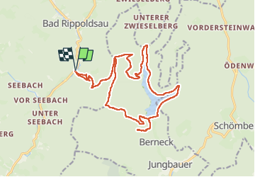
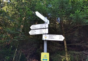
Tour Wandern von 21 km verfügbar auf Baden-Württemberg, Landkreis Freudenstadt, Bad Rippoldsau-Schapbach. Diese Tour wird von Bart2015 vorgeschlagen.
Beschreibung
Belle rando assez physique pour découvrir à pied la région de Bad Rippoldsau. De belles découvertes comme les réserve souvent la Forêt Noire. Excellente condition physique nécessaire.
Bonne rando, soyez prudent ...
Ort
Land:
Germany
Region :
Baden-Württemberg
Abteilung/Provinz :
Landkreis Freudenstadt
Kommune :
Bad Rippoldsau-Schapbach
Standort:
Unknown
Gehen Sie:(Dec)
Gehen Sie:(UTM)
450347 ; 5362445 (32U) N.
Kommentare
Touren in der Umgebung
![Tour Zu Fuß Bad Rippoldsau-Schapbach - Bad Rippoldsau - Burgbachhöhe (Mittelweg) - Photo](https://media.geolcdn.com/t/375/260/35019236-3d2a-4e92-a8c8-def75f614134.jpeg&format=jpg&maxdim=2)
![Zu Fuß Zu Fuß](https://static1.geolcdn.com/sitytour/trail-icons/100.png)
Bad Rippoldsau - Burgbachhöhe (Mittelweg)
Zu Fuß
Einfach
Bad Rippoldsau-Schapbach,
Baden-Württemberg,
Landkreis Freudenstadt,
Germany
![](/images/other/stat-length.png)
5,4 km | 9,5 km-effort
2h 10min
![](https://static1.geolcdn.com/siteimages/upload/files/16400158638029165_repeat_loop_refresh_sync_direction_icon.png)
Nein
![Tour Zu Fuß Bad Rippoldsau-Schapbach - Klösterle-Schleife - Photo](https://media.geolcdn.com/t/375/260/35019236-3d2a-4e92-a8c8-def75f614134.jpeg&format=jpg&maxdim=2)
![Zu Fuß Zu Fuß](https://static1.geolcdn.com/sitytour/trail-icons/100.png)
Klösterle-Schleife
Zu Fuß
Einfach
Bad Rippoldsau-Schapbach,
Baden-Württemberg,
Landkreis Freudenstadt,
Germany
![](/images/other/stat-length.png)
4,9 km | 7,7 km-effort
1h 45min
![](https://static1.geolcdn.com/siteimages/upload/files/16400158638029165_repeat_loop_refresh_sync_direction_icon.png)
Nein
![Tour Zu Fuß Bad Rippoldsau-Schapbach - Vor Seebach - Glaswaldsee - Photo](https://media.geolcdn.com/t/375/260/32ce469d-a806-4819-b37d-db55f9f1db0c.jpeg&format=jpg&maxdim=2)
![Zu Fuß Zu Fuß](https://static1.geolcdn.com/sitytour/trail-icons/100.png)
Vor Seebach - Glaswaldsee
Zu Fuß
Einfach
Bad Rippoldsau-Schapbach,
Baden-Württemberg,
Landkreis Freudenstadt,
Germany
![](/images/other/stat-length.png)
6,7 km | 11,3 km-effort
2h 34min
![](https://static1.geolcdn.com/siteimages/upload/files/16400158638029165_repeat_loop_refresh_sync_direction_icon.png)
Nein
![Tour Zu Fuß Bad Rippoldsau-Schapbach - Schapbach - See Ebene - Photo](https://media.geolcdn.com/t/375/260/32ce469d-a806-4819-b37d-db55f9f1db0c.jpeg&format=jpg&maxdim=2)
![Zu Fuß Zu Fuß](https://static1.geolcdn.com/sitytour/trail-icons/100.png)
Schapbach - See Ebene
Zu Fuß
Einfach
Bad Rippoldsau-Schapbach,
Baden-Württemberg,
Landkreis Freudenstadt,
Germany
![](/images/other/stat-length.png)
8,2 km | 14,4 km-effort
3h 16min
![](https://static1.geolcdn.com/siteimages/upload/files/16400158638029165_repeat_loop_refresh_sync_direction_icon.png)
Nein
![Tour Zu Fuß Bad Rippoldsau-Schapbach - Bad Rippoldsau-Bad - Holzwald - Photo](https://media.geolcdn.com/t/375/260/92faf645-c748-4220-928f-736f9ccc9657.jpeg&format=jpg&maxdim=2)
![Zu Fuß Zu Fuß](https://static1.geolcdn.com/sitytour/trail-icons/100.png)
Bad Rippoldsau-Bad - Holzwald
Zu Fuß
Einfach
Bad Rippoldsau-Schapbach,
Baden-Württemberg,
Landkreis Freudenstadt,
Germany
![](/images/other/stat-length.png)
3,4 km | 5,2 km-effort
1h 11min
![](https://static1.geolcdn.com/siteimages/upload/files/16400158638029165_repeat_loop_refresh_sync_direction_icon.png)
Nein
![Tour Zu Fuß Bad Rippoldsau-Schapbach - Panoramaweg Bad Rippoldsau - Photo](https://media.geolcdn.com/t/375/260/92faf645-c748-4220-928f-736f9ccc9657.jpeg&format=jpg&maxdim=2)
![Zu Fuß Zu Fuß](https://static1.geolcdn.com/sitytour/trail-icons/100.png)
Panoramaweg Bad Rippoldsau
Zu Fuß
Einfach
Bad Rippoldsau-Schapbach,
Baden-Württemberg,
Landkreis Freudenstadt,
Germany
![](/images/other/stat-length.png)
3,3 km | 4,9 km-effort
1h 7min
![](https://static1.geolcdn.com/siteimages/upload/files/16400158638029165_repeat_loop_refresh_sync_direction_icon.png)
Nein
![Tour Zu Fuß Bad Rippoldsau-Schapbach - Bad Rippoldsau - Grüne Sitzbank - Photo](https://media.geolcdn.com/t/375/260/92faf645-c748-4220-928f-736f9ccc9657.jpeg&format=jpg&maxdim=2)
![Zu Fuß Zu Fuß](https://static1.geolcdn.com/sitytour/trail-icons/100.png)
Bad Rippoldsau - Grüne Sitzbank
Zu Fuß
Einfach
Bad Rippoldsau-Schapbach,
Baden-Württemberg,
Landkreis Freudenstadt,
Germany
![](/images/other/stat-length.png)
3,4 km | 6,9 km-effort
1h 33min
![](https://static1.geolcdn.com/siteimages/upload/files/16400158638029165_repeat_loop_refresh_sync_direction_icon.png)
Nein
![Tour Zu Fuß Bad Rippoldsau-Schapbach - Bad Rippoldsau - Glaswald-Sattelege - Photo](https://media.geolcdn.com/t/375/260/ad89a840-b260-4d04-a6e2-3d195d17c289.jpeg&format=jpg&maxdim=2)
![Zu Fuß Zu Fuß](https://static1.geolcdn.com/sitytour/trail-icons/100.png)
Bad Rippoldsau - Glaswald-Sattelege
Zu Fuß
Einfach
Bad Rippoldsau-Schapbach,
Baden-Württemberg,
Landkreis Freudenstadt,
Germany
![](/images/other/stat-length.png)
6,8 km | 10,9 km-effort
2h 29min
![](https://static1.geolcdn.com/siteimages/upload/files/16400158638029165_repeat_loop_refresh_sync_direction_icon.png)
Nein
![Tour Zu Fuß Bad Rippoldsau-Schapbach - Am Wolfenberg - Kleiner Absbach - Photo](https://media.geolcdn.com/t/375/260/ext.jpg?maxdim=2&url=https%3A%2F%2Fstatic1.geolcdn.com%2Fsiteimages%2Fupload%2Ffiles%2F1545311037marcheuse_200dpi.jpg)
![Zu Fuß Zu Fuß](https://static1.geolcdn.com/sitytour/trail-icons/100.png)
Am Wolfenberg - Kleiner Absbach
Zu Fuß
Einfach
Bad Rippoldsau-Schapbach,
Baden-Württemberg,
Landkreis Freudenstadt,
Germany
![](/images/other/stat-length.png)
3,9 km | 5,2 km-effort
1h 11min
![](https://static1.geolcdn.com/siteimages/upload/files/16400158638029165_repeat_loop_refresh_sync_direction_icon.png)
Nein