![](/images/other/stat-length.png)
![Tour Wandern Ouzous - Pic du Pibeste - Photo](https://media.geolcdn.com/t/1900/400/ext.pjpeg?maxdim=2&url=https%3A%2F%2Fstatic1.geolcdn.com%2Fsiteimages%2Fupload%2Ffiles%2F1553511878bg_sport_marche.png)
Pic du Pibeste
loicthev
Benutzer
![Länge](/images/other/stat-length.png)
Länge
13,4 km
![Maximale Höhe](https://static1.geolcdn.com/siteimages/upload/files/1508320355ic_sort_altitude_max_24dp.png)
Maximale Höhe
1424 m
![Positive Höhendifferenz](https://static1.geolcdn.com/siteimages/upload/files/1508320355ic_sort_den_pos_24dp.png)
Positive Höhendifferenz
1018 m
![Km-Effort](/images/other/stat-length.png)
Km-Effort
27 km
![Min. Höhe](https://static1.geolcdn.com/siteimages/upload/files/1508320355ic_sort_altitude_min_24dp.png)
Min. Höhe
450 m
![Negative Höhendifferenz](https://static1.geolcdn.com/siteimages/upload/files/1508320355ic_sort_den_neg_24dp.png)
Negative Höhendifferenz
1015 m
![Boucle](https://static1.geolcdn.com/siteimages/upload/files/16400158638029165_repeat_loop_refresh_sync_direction_icon.png)
Boucle
Ja
Erstellungsdatum :
2024-10-28 12:04:18.019
Letzte Änderung :
2024-10-28 17:00:18.19
![Wandern](https://static1.geolcdn.com/sitytour/trail-icons/101.png)
3h30
Schwierigkeit : Medium
![Scannen Sie diesen QR-Code, um die Tour in der SityTrail-Anwendung zu öffnen](https://capi.geolives.com/qq0zvz2zws4bq2lad0pu/sitytour/trails/4239598/qr.png?size=200)
Kostenlosegpshiking-Anwendung
Über SityTrail
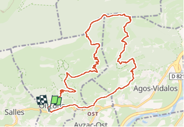
Tour Wandern von 13,4 km verfügbar auf Okzitanien, Hautes-Pyrénées, Ouzous. Diese Tour wird von loicthev vorgeschlagen.
Beschreibung
rando Pibeste
Ouzous > Pic du Pibeste par le Trou > Pène de Souquète > Col des Portes > Ouzous
28/10/2024
Alexandre
Ort
Land:
France
Region :
Okzitanien
Abteilung/Provinz :
Hautes-Pyrénées
Kommune :
Ouzous
Standort:
Unknown
Gehen Sie:(Dec)
Gehen Sie:(UTM)
735639 ; 4768039 (30T) N.
Kommentare
Touren in der Umgebung
![Tour Wandern Arcizans-Dessus - la fontaine de Nabias - Photo](https://media.geolcdn.com/t/375/260/7a92cfc2-a248-4e38-88ec-b8751d1d13fa.jpg&format=jpg&maxdim=2)
![Wandern Wandern](https://static1.geolcdn.com/sitytour/trail-icons/101.png)
la fontaine de Nabias
Wandern
Sehr leicht
(1)
Arcizans-Dessus,
Okzitanien,
Hautes-Pyrénées,
France
![](/images/other/stat-length.png)
4,2 km | 6,8 km-effort
1h 40min
![](https://static1.geolcdn.com/siteimages/upload/files/16400158638029165_repeat_loop_refresh_sync_direction_icon.png)
Ja
![Tour Wandern Argelès-Gazost - Le Mont de Gez en circuit - Argelès Gazost - Photo](https://media.geolcdn.com/t/375/260/ext.jpg?maxdim=2&url=https%3A%2F%2Fservices.sitytrail.com%2FGeolivesWS%2FDownloadMedia.ashx%3FTrailID%3D172309%26Media%3D13627_4.jpg)
![Wandern Wandern](https://static1.geolcdn.com/sitytour/trail-icons/101.png)
Le Mont de Gez en circuit - Argelès Gazost
Wandern
Medium
(1)
Argelès-Gazost,
Okzitanien,
Hautes-Pyrénées,
France
![](/images/other/stat-length.png)
11,8 km | 20 km-effort
4h 30min
![](https://static1.geolcdn.com/siteimages/upload/files/16400158638029165_repeat_loop_refresh_sync_direction_icon.png)
Ja
![Tour Wandern Ségus - col du pré du roi par segus reconnu - Photo](https://media.geolcdn.com/t/375/260/8a292310-c3a3-4003-ab0e-617cb49dc561.jpg&format=jpg&maxdim=2)
![Wandern Wandern](https://static1.geolcdn.com/sitytour/trail-icons/101.png)
col du pré du roi par segus reconnu
Wandern
Schwierig
(1)
Ségus,
Okzitanien,
Hautes-Pyrénées,
France
![](/images/other/stat-length.png)
10,4 km | 16,8 km-effort
3h 49min
![](https://static1.geolcdn.com/siteimages/upload/files/16400158638029165_repeat_loop_refresh_sync_direction_icon.png)
Ja
![Tour Elektrofahrrad Argelès-Gazost - CABALIROS 30 JUIN 2023 - Photo](https://media.geolcdn.com/t/375/260/d00efa13-e401-495e-87f8-f59eb1442703.jpg&format=jpg&maxdim=2)
![Elektrofahrrad Elektrofahrrad](https://static1.geolcdn.com/sitytour/trail-icons/205.png)
CABALIROS 30 JUIN 2023
Elektrofahrrad
Medium
Argelès-Gazost,
Okzitanien,
Hautes-Pyrénées,
France
![](/images/other/stat-length.png)
39 km | 57 km-effort
4h 47min
![](https://static1.geolcdn.com/siteimages/upload/files/16400158638029165_repeat_loop_refresh_sync_direction_icon.png)
Ja
![Tour Wandern Argelès-Gazost - ARGELES La boucle de l arrieulat - Photo](https://media.geolcdn.com/t/375/260/cee8eb17-b22b-4615-9318-bf7446bdbe22.jpg&format=jpg&maxdim=2)
![Wandern Wandern](https://static1.geolcdn.com/sitytour/trail-icons/101.png)
ARGELES La boucle de l arrieulat
Wandern
Schwierig
Argelès-Gazost,
Okzitanien,
Hautes-Pyrénées,
France
![](/images/other/stat-length.png)
10,3 km | 14,6 km-effort
3h 4min
![](https://static1.geolcdn.com/siteimages/upload/files/16400158638029165_repeat_loop_refresh_sync_direction_icon.png)
Ja
![Tour Wandern Argelès-Gazost - ARGELES Mont de Gez G3 fait - Photo](https://media.geolcdn.com/t/375/260/653c1198-5439-4c4b-acf2-a53537be36e4.jpg&format=jpg&maxdim=2)
![Wandern Wandern](https://static1.geolcdn.com/sitytour/trail-icons/101.png)
ARGELES Mont de Gez G3 fait
Wandern
Medium
Argelès-Gazost,
Okzitanien,
Hautes-Pyrénées,
France
![](/images/other/stat-length.png)
10,2 km | 18,3 km-effort
5h 39min
![](https://static1.geolcdn.com/siteimages/upload/files/16400158638029165_repeat_loop_refresh_sync_direction_icon.png)
Ja
![Tour Wandern Ouzous - Ouzous pibeste-fait - Photo](https://media.geolcdn.com/t/375/260/ext.jpg?maxdim=2&url=https%3A%2F%2Fstatic1.geolcdn.com%2Fsiteimages%2Fupload%2Ffiles%2F1553511878bg_sport_marche.png)
![Wandern Wandern](https://static1.geolcdn.com/sitytour/trail-icons/101.png)
Ouzous pibeste-fait
Wandern
Medium
(1)
Ouzous,
Okzitanien,
Hautes-Pyrénées,
France
![](/images/other/stat-length.png)
11,3 km | 22 km-effort
4h 29min
![](https://static1.geolcdn.com/siteimages/upload/files/16400158638029165_repeat_loop_refresh_sync_direction_icon.png)
Ja
![Tour Wandern Ouzous - Pic du Pibeste - Photo](https://media.geolcdn.com/t/375/260/ext.jpg?maxdim=2&url=https%3A%2F%2Fstatic1.geolcdn.com%2Fsiteimages%2Fupload%2Ffiles%2F1553511878bg_sport_marche.png)
![Wandern Wandern](https://static1.geolcdn.com/sitytour/trail-icons/101.png)
Pic du Pibeste
Wandern
Medium
(1)
Ouzous,
Okzitanien,
Hautes-Pyrénées,
France
![](/images/other/stat-length.png)
13 km | 25 km-effort
6h 9min
![](https://static1.geolcdn.com/siteimages/upload/files/16400158638029165_repeat_loop_refresh_sync_direction_icon.png)
Ja
![Tour Wandern Salles - Escala du Prat du Rey - Photo](https://media.geolcdn.com/t/375/260/ext.jpg?maxdim=2&url=https%3A%2F%2Fstatic1.geolcdn.com%2Fsiteimages%2Fupload%2Ffiles%2F1553511878bg_sport_marche.png)
![Wandern Wandern](https://static1.geolcdn.com/sitytour/trail-icons/101.png)
Escala du Prat du Rey
Wandern
Medium
(1)
Salles,
Okzitanien,
Hautes-Pyrénées,
France
![](/images/other/stat-length.png)
11,3 km | 22 km-effort
4h 24min
![](https://static1.geolcdn.com/siteimages/upload/files/16400158638029165_repeat_loop_refresh_sync_direction_icon.png)
Ja