![](/images/other/stat-length.png)
![Tour Wandern La Louvière - Houdeng_vers_Bois-du-Luc - Photo](https://media.geolcdn.com/t/1900/400/ext.pjpeg?maxdim=2&url=https%3A%2F%2Fstatic1.geolcdn.com%2Fsiteimages%2Fupload%2Ffiles%2F1553511878bg_sport_marche.png)
Houdeng_vers_Bois-du-Luc
Claude7100
Benutzer
![Länge](/images/other/stat-length.png)
Länge
7,1 km
![Maximale Höhe](https://static1.geolcdn.com/siteimages/upload/files/1508320355ic_sort_altitude_max_24dp.png)
Maximale Höhe
120 m
![Positive Höhendifferenz](https://static1.geolcdn.com/siteimages/upload/files/1508320355ic_sort_den_pos_24dp.png)
Positive Höhendifferenz
86 m
![Km-Effort](/images/other/stat-length.png)
Km-Effort
8,2 km
![Min. Höhe](https://static1.geolcdn.com/siteimages/upload/files/1508320355ic_sort_altitude_min_24dp.png)
Min. Höhe
76 m
![Negative Höhendifferenz](https://static1.geolcdn.com/siteimages/upload/files/1508320355ic_sort_den_neg_24dp.png)
Negative Höhendifferenz
86 m
![Boucle](https://static1.geolcdn.com/siteimages/upload/files/16400158638029165_repeat_loop_refresh_sync_direction_icon.png)
Boucle
Ja
Erstellungsdatum :
2024-10-22 13:46:53.273
Letzte Änderung :
2024-10-22 13:52:18.722
![Wandern](https://static1.geolcdn.com/sitytour/trail-icons/101.png)
1h52
Schwierigkeit : Medium
![Scannen Sie diesen QR-Code, um die Tour in der SityTrail-Anwendung zu öffnen](https://capi.geolives.com/qq0zvz2zws4bq2lad0pu/sitytour/trails/4233323/qr.png?size=200)
Kostenlosegpshiking-Anwendung
Über SityTrail
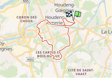
Tour Wandern von 7,1 km verfügbar auf Wallonien, Hennegau, La Louvière. Diese Tour wird von Claude7100 vorgeschlagen.
Beschreibung
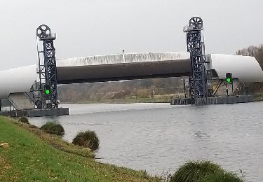
Boucle entre Houdeng-Goegnies et Bois-du-Luc.
Départ sur le parking de L'Intermarché - chaussée Houtart 147 à La Louvière
Ort
Land:
Belgium
Region :
Wallonien
Abteilung/Provinz :
Hennegau
Kommune :
La Louvière
Standort:
Unknown
Gehen Sie:(Dec)
Gehen Sie:(UTM)
582476 ; 5592998 (31U) N.
Kommentare
Touren in der Umgebung
![Tour Wandern Le Rœulx - Tracé 30 mai 2019 à 21-51 - Photo](https://media.geolcdn.com/t/375/260/4ab1d82d-037a-45cc-b066-dd8dceb68df8.jpeg&format=jpg&maxdim=2)
![Wandern Wandern](https://static1.geolcdn.com/sitytour/trail-icons/101.png)
Tracé 30 mai 2019 à 21-51
Wandern
Einfach
(1)
Le Rœulx,
Wallonien,
Hennegau,
Belgium
![](/images/other/stat-length.png)
15,2 km | 17,4 km-effort
3h 50min
![](https://static1.geolcdn.com/siteimages/upload/files/16400158638029165_repeat_loop_refresh_sync_direction_icon.png)
Ja
![Tour Wandern Le Rœulx - Balade champêtre au Roeulx - Photo](https://media.geolcdn.com/t/375/260/ext.jpg?maxdim=2&url=https%3A%2F%2Fservices.sitytrail.com%2FGeolivesWS%2FDownloadMedia.ashx%3FTrailID%3D108082%26Media%3D0713eccb-7649-4b02-8bb5-985a3300c10f.JPG)
![Wandern Wandern](https://static1.geolcdn.com/sitytour/trail-icons/101.png)
Balade champêtre au Roeulx
Wandern
Einfach
(1)
Le Rœulx,
Wallonien,
Hennegau,
Belgium
![](/images/other/stat-length.png)
10,9 km | 12,8 km-effort
2h 40min
![](https://static1.geolcdn.com/siteimages/upload/files/16400158638029165_repeat_loop_refresh_sync_direction_icon.png)
Ja
![Tour Fahrrad La Louvière - Cantine des Italiens-Canal du centre-Bois du Luc - Photo](https://media.geolcdn.com/t/375/260/ext.jpg?maxdim=2&url=https%3A%2F%2Fservices.sitytrail.com%2FGeolivesWS%2FDownloadMedia.ashx%3FTrailID%3D797348%26Media%3Dfix__20170727115839.jpg)
![Fahrrad Fahrrad](https://static1.geolcdn.com/sitytour/trail-icons/200.png)
Cantine des Italiens-Canal du centre-Bois du Luc
Fahrrad
Einfach
(3)
La Louvière,
Wallonien,
Hennegau,
Belgium
![](/images/other/stat-length.png)
31 km | 35 km-effort
2h 1min
![](https://static1.geolcdn.com/siteimages/upload/files/16400158638029165_repeat_loop_refresh_sync_direction_icon.png)
Ja
![Tour Fahrrad La Louvière - Ascenseurs du Centre Strepy Thieu Bracquenies - Photo](https://media.geolcdn.com/t/375/260/ext.jpg?maxdim=2&url=https%3A%2F%2Fservices.sitytrail.com%2FGeolivesWS%2FDownloadMedia.ashx%3FTrailID%3D1074392%26Media%3Dfix__20181120130643.jpg)
![Fahrrad Fahrrad](https://static1.geolcdn.com/sitytour/trail-icons/200.png)
Ascenseurs du Centre Strepy Thieu Bracquenies
Fahrrad
Einfach
(1)
La Louvière,
Wallonien,
Hennegau,
Belgium
![](/images/other/stat-length.png)
18,5 km | 22 km-effort
3h 7min
![](https://static1.geolcdn.com/siteimages/upload/files/16400158638029165_repeat_loop_refresh_sync_direction_icon.png)
Ja
![Tour Wandern La Louvière - A la découverte du Canal du Centre - Houdeng Aimeries - Photo](https://media.geolcdn.com/t/375/260/ext.jpg?maxdim=2&url=https%3A%2F%2Fstatic1.geolcdn.com%2Fsiteimages%2Fupload%2Ffiles%2F1553511878bg_sport_marche.png)
![Wandern Wandern](https://static1.geolcdn.com/sitytour/trail-icons/101.png)
A la découverte du Canal du Centre - Houdeng Aimeries
Wandern
Einfach
(4)
La Louvière,
Wallonien,
Hennegau,
Belgium
![](/images/other/stat-length.png)
12,9 km | 15,4 km-effort
3h 0min
![](https://static1.geolcdn.com/siteimages/upload/files/16400158638029165_repeat_loop_refresh_sync_direction_icon.png)
Ja
![Tour Wandern Le Rœulx - BE-Le Roeulx - La Haye du Roeulx - Domaine Aldo Vastapane - W - Photo](https://media.geolcdn.com/t/375/260/dd72392e-02a4-40c7-936e-9b75c105e7f1.jpg&format=jpg&maxdim=2)
![Wandern Wandern](https://static1.geolcdn.com/sitytour/trail-icons/101.png)
BE-Le Roeulx - La Haye du Roeulx - Domaine Aldo Vastapane - W
Wandern
Medium
Le Rœulx,
Wallonien,
Hennegau,
Belgium
![](/images/other/stat-length.png)
6,4 km | 7,5 km-effort
1h 41min
![](https://static1.geolcdn.com/siteimages/upload/files/16400158638029165_repeat_loop_refresh_sync_direction_icon.png)
Ja
![Mountainbike Mountainbike](https://static1.geolcdn.com/sitytour/trail-icons/202.png)
Le_Roeulx_20221025_100916 (1)
Mountainbike
Sehr schwierig
Le Rœulx,
Wallonien,
Hennegau,
Belgium
![](/images/other/stat-length.png)
49 km | 57 km-effort
3h 58min
![](https://static1.geolcdn.com/siteimages/upload/files/16400158638029165_repeat_loop_refresh_sync_direction_icon.png)
Nein
![Tour Wandern La Louvière - La balade des ascenseurs - Houdeng-Aimeries - Photo](https://media.geolcdn.com/t/375/260/d99da6dd-7e06-432a-8742-a2cbb7aa82e8.jpeg&format=jpg&maxdim=2)
![Wandern Wandern](https://static1.geolcdn.com/sitytour/trail-icons/101.png)
La balade des ascenseurs - Houdeng-Aimeries
Wandern
Medium
La Louvière,
Wallonien,
Hennegau,
Belgium
![](/images/other/stat-length.png)
8 km | 9,1 km-effort
3h 42min
![](https://static1.geolcdn.com/siteimages/upload/files/16400158638029165_repeat_loop_refresh_sync_direction_icon.png)
Ja
![Tour Wandern La Louvière - Strépy-Bracquegnies - Canal et Ascenseur n°1 - Photo](https://media.geolcdn.com/t/375/260/ext.jpg?maxdim=2&url=https%3A%2F%2Fstatic1.geolcdn.com%2Fsiteimages%2Fupload%2Ffiles%2F1553511878bg_sport_marche.png)
![Wandern Wandern](https://static1.geolcdn.com/sitytour/trail-icons/101.png)
Strépy-Bracquegnies - Canal et Ascenseur n°1
Wandern
Medium
(2)
La Louvière,
Wallonien,
Hennegau,
Belgium
![](/images/other/stat-length.png)
8,8 km | 10,1 km-effort
2h 17min
![](https://static1.geolcdn.com/siteimages/upload/files/16400158638029165_repeat_loop_refresh_sync_direction_icon.png)
Ja