![](/images/other/stat-length.png)
![Tour Wandern Plan-d'Aups-Sainte-Baume - Massif et crête de la Sainte Baume - Mont Pilon - Grotte de Marie-Madeleine - Photo](https://media.geolcdn.com/t/1900/400/ext.pjpeg?maxdim=2&url=https%3A%2F%2Fstatic1.geolcdn.com%2Fsiteimages%2Fupload%2Ffiles%2F1553511878bg_sport_marche.png)
Massif et crête de la Sainte Baume - Mont Pilon - Grotte de Marie-Madeleine
GSananes
Benutzer
![Länge](/images/other/stat-length.png)
Länge
13,3 km
![Maximale Höhe](https://static1.geolcdn.com/siteimages/upload/files/1508320355ic_sort_altitude_max_24dp.png)
Maximale Höhe
1140 m
![Positive Höhendifferenz](https://static1.geolcdn.com/siteimages/upload/files/1508320355ic_sort_den_pos_24dp.png)
Positive Höhendifferenz
585 m
![Km-Effort](/images/other/stat-length.png)
Km-Effort
21 km
![Min. Höhe](https://static1.geolcdn.com/siteimages/upload/files/1508320355ic_sort_altitude_min_24dp.png)
Min. Höhe
681 m
![Negative Höhendifferenz](https://static1.geolcdn.com/siteimages/upload/files/1508320355ic_sort_den_neg_24dp.png)
Negative Höhendifferenz
584 m
![Boucle](https://static1.geolcdn.com/siteimages/upload/files/16400158638029165_repeat_loop_refresh_sync_direction_icon.png)
Boucle
Ja
Erstellungsdatum :
2024-10-19 18:04:32.875
Letzte Änderung :
2024-10-19 18:04:36.313
![Wandern](https://static1.geolcdn.com/sitytour/trail-icons/101.png)
4h47
Schwierigkeit : Schwierig
![Scannen Sie diesen QR-Code, um die Tour in der SityTrail-Anwendung zu öffnen](https://capi.geolives.com/qq0zvz2zws4bq2lad0pu/sitytour/trails/4230244/qr.png?size=200)
Kostenlosegpshiking-Anwendung
Über SityTrail
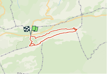
Tour Wandern von 13,3 km verfügbar auf Provence-Alpes-Côte d'Azur, Var, Plan-d'Aups-Sainte-Baume. Diese Tour wird von GSananes vorgeschlagen.
Beschreibung
Reconnue avec Chantal le 19 octobre 2024
Petite difficulté au Pas de l'Ai (on met les mains pour passer quelques rochers)
passage très court pour monter sur la crête
Deuxième petite difficulté en descente après le dernier sommet sur les crêtes
Ort
Land:
France
Region :
Provence-Alpes-Côte d'Azur
Abteilung/Provinz :
Var
Kommune :
Plan-d'Aups-Sainte-Baume
Standort:
Unknown
Gehen Sie:(Dec)
Gehen Sie:(UTM)
724191 ; 4801821 (31T) N.
Kommentare
Touren in der Umgebung
![Tour Wandern Plan-d'Aups-Sainte-Baume - Sainte Baume 8,5 km - Photo](https://media.geolcdn.com/t/375/260/02bfd54c-87ac-472a-9dd7-603e289d99c6.jpeg&format=jpg&maxdim=2)
![Wandern Wandern](https://static1.geolcdn.com/sitytour/trail-icons/101.png)
Sainte Baume 8,5 km
Wandern
Medium
(1)
Plan-d'Aups-Sainte-Baume,
Provence-Alpes-Côte d'Azur,
Var,
France
![](/images/other/stat-length.png)
8,4 km | 15,5 km-effort
4h 38min
![](https://static1.geolcdn.com/siteimages/upload/files/16400158638029165_repeat_loop_refresh_sync_direction_icon.png)
Ja
![Tour Wandern Nans-les-Pins - Le baou des glacières - Photo](https://media.geolcdn.com/t/375/260/ext.jpg?maxdim=2&url=https%3A%2F%2Fservices.sitytrail.com%2FGeolivesWS%2FDownloadMedia.ashx%3FTrailID%3D356935%26Media%3Dfix__20141025130409.jpg)
![Wandern Wandern](https://static1.geolcdn.com/sitytour/trail-icons/101.png)
Le baou des glacières
Wandern
Medium
(1)
Nans-les-Pins,
Provence-Alpes-Côte d'Azur,
Var,
France
![](/images/other/stat-length.png)
7,6 km | 12,2 km-effort
4h 27min
![](https://static1.geolcdn.com/siteimages/upload/files/16400158638029165_repeat_loop_refresh_sync_direction_icon.png)
Ja
![Tour Wandern Plan-d'Aups-Sainte-Baume - SityTrail - Sentier merveilleux - La Ste baume - Le Plan d'aups - Photo](https://media.geolcdn.com/t/375/260/e69b33b5-1427-482e-bef6-59e868e7cd87.jpg&format=jpg&maxdim=2)
![Wandern Wandern](https://static1.geolcdn.com/sitytour/trail-icons/101.png)
SityTrail - Sentier merveilleux - La Ste baume - Le Plan d'aups
Wandern
Medium
(1)
Plan-d'Aups-Sainte-Baume,
Provence-Alpes-Côte d'Azur,
Var,
France
![](/images/other/stat-length.png)
15 km | 23 km-effort
6h 0min
![](https://static1.geolcdn.com/siteimages/upload/files/16400158638029165_repeat_loop_refresh_sync_direction_icon.png)
Ja
![Tour Wandern Plan-d'Aups-Sainte-Baume - Crêts de la Ste Baume - Photo](https://media.geolcdn.com/t/375/260/ext.jpg?maxdim=2&url=https%3A%2F%2Fservices.sitytrail.com%2FGeolivesWS%2FDownloadMedia.ashx%3FTrailID%3D214866%26Media%3D15409_2.jpg)
![Wandern Wandern](https://static1.geolcdn.com/sitytour/trail-icons/101.png)
Crêts de la Ste Baume
Wandern
Medium
(2)
Plan-d'Aups-Sainte-Baume,
Provence-Alpes-Côte d'Azur,
Var,
France
![](/images/other/stat-length.png)
15,4 km | 23 km-effort
5h 0min
![](https://static1.geolcdn.com/siteimages/upload/files/16400158638029165_repeat_loop_refresh_sync_direction_icon.png)
Ja
![Tour Wandern Nans-les-Pins - La Croix des Glacières, Sainte-Baume - Photo](https://media.geolcdn.com/t/375/260/ext.jpg?maxdim=2&url=https%3A%2F%2Fservices.sitytrail.com%2FGeolivesWS%2FDownloadMedia.ashx%3FTrailID%3D107654%26Media%3D12647_1.jpg)
![Wandern Wandern](https://static1.geolcdn.com/sitytour/trail-icons/101.png)
La Croix des Glacières, Sainte-Baume
Wandern
Medium
(1)
Nans-les-Pins,
Provence-Alpes-Côte d'Azur,
Var,
France
![](/images/other/stat-length.png)
7,2 km | 12 km-effort
3h 19min
![](https://static1.geolcdn.com/siteimages/upload/files/16400158638029165_repeat_loop_refresh_sync_direction_icon.png)
Ja
![Tour Wandern Plan-d'Aups-Sainte-Baume - Du Col du Saint-Pilon au Pas de l'Aï, Sainte Baume - Photo](https://media.geolcdn.com/t/375/260/ext.jpg?maxdim=2&url=https%3A%2F%2Fservices.sitytrail.com%2FGeolivesWS%2FDownloadMedia.ashx%3FTrailID%3D107608%26Media%3D12576_1.jpg)
![Wandern Wandern](https://static1.geolcdn.com/sitytour/trail-icons/101.png)
Du Col du Saint-Pilon au Pas de l'Aï, Sainte Baume
Wandern
Medium
(1)
Plan-d'Aups-Sainte-Baume,
Provence-Alpes-Côte d'Azur,
Var,
France
![](/images/other/stat-length.png)
13,1 km | 20 km-effort
5h 15min
![](https://static1.geolcdn.com/siteimages/upload/files/16400158638029165_repeat_loop_refresh_sync_direction_icon.png)
Ja
![Tour Wandern Riboux - Riboux - Forêt de Malaucène - Photo](https://media.geolcdn.com/t/375/260/ext.jpg?maxdim=2&url=https%3A%2F%2Fservices.sitytrail.com%2FGeolivesWS%2FDownloadMedia.ashx%3FTrailID%3D103921%26Media%3D6772_2.jpg)
![Wandern Wandern](https://static1.geolcdn.com/sitytour/trail-icons/101.png)
Riboux - Forêt de Malaucène
Wandern
Medium
(4)
Riboux,
Provence-Alpes-Côte d'Azur,
Var,
France
![](/images/other/stat-length.png)
12,2 km | 15,2 km-effort
2h 40min
![](https://static1.geolcdn.com/siteimages/upload/files/16400158638029165_repeat_loop_refresh_sync_direction_icon.png)
Ja
![Tour Wandern Plan-d'Aups-Sainte-Baume - La Grotte aux oiseaux - Plan d'Aups - Photo](https://media.geolcdn.com/t/375/260/ext.jpg?maxdim=2&url=https%3A%2F%2Fservices.sitytrail.com%2FGeolivesWS%2FDownloadMedia.ashx%3FTrailID%3D103826%26Media%3D6600_1.jpg)
![Wandern Wandern](https://static1.geolcdn.com/sitytour/trail-icons/101.png)
La Grotte aux oiseaux - Plan d'Aups
Wandern
Medium
(1)
Plan-d'Aups-Sainte-Baume,
Provence-Alpes-Côte d'Azur,
Var,
France
![](/images/other/stat-length.png)
8,8 km | 12,5 km-effort
2h 30min
![](https://static1.geolcdn.com/siteimages/upload/files/16400158638029165_repeat_loop_refresh_sync_direction_icon.png)
Ja
![Tour Wandern Saint-Zacharie - Sources des Nayes - Photo](https://media.geolcdn.com/t/375/260/f10876bf-7b9c-4295-a050-83953c85f7a8.jpg&format=jpg&maxdim=2)
![Wandern Wandern](https://static1.geolcdn.com/sitytour/trail-icons/101.png)
Sources des Nayes
Wandern
Medium
Saint-Zacharie,
Provence-Alpes-Côte d'Azur,
Var,
France
![](/images/other/stat-length.png)
7,6 km | 9,6 km-effort
1h 47min
![](https://static1.geolcdn.com/siteimages/upload/files/16400158638029165_repeat_loop_refresh_sync_direction_icon.png)
Ja